METAR & TAF 37S
37S does not publish a METAR.
Showing the nearest reporting station: KGGW (WOKAL FLD/GLASGOW-VALLEY COUNTY) · 13.6 NM away. Conditions at 37S may differ.
METAR · KGGW
Observed 02:53Z
KGGW 270253Z AUTO 12004KT 3SM HZ OVC043 29/06 A2986 RMK AO2 SLP093 T02890061 53002 TSNO
- Wind
- 120° @ 4 kt
- Visibility
- 3 SM
- Temp / Dew
- 29°C / 6°C
- Altimeter
- 29.86 inHg
- Clouds
- OVC
- Density alt
- 4,594 ft
- Ceiling
- 4,300 ft AGL
- Rules
- MVFR
Airport info & contacts
Manager on record, flight service, ARTCC, attendance schedule and pattern altitude — published by the FAA and refreshed every 28 days.
Location
- From city
- 1 NM W
- VFR sectional
- BILLINGS
- ARTCC
- ZLC · SALT LAKE CITY
- NOTAM facility
- GTF (NOTAM-D)
Airport manager
- Name
- LANNY HANSON
- Phone
- 406-263-1154
- Address
- P.O. BOX 247, FT PECK MT 59223
Flight service · Hours
- FSS GTF
- GREAT FALLS1-800-WX-BRIEF
- Attendance
- Unattended
Frequencies
Tap any row to copy the frequency to your clipboard.
Runways & pattern
Full pagePattern entry · RWY 05
LEFT TRAFFICRunway end performance
| End | TORA | TODA | ASDA | LDA | VGSI | Approach lights | Obstruction |
|---|---|---|---|---|---|---|---|
| 05 | — | — | — | — | — | — | 68', trees, 841' from thr, 0' R of cntrln, slope 12 |
Declared distances in feet. TORA = takeoff run available, TODA = takeoff distance, ASDA = accelerate-stop, LDA = landing distance.
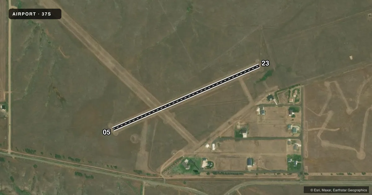
Airport sketch
Runways drawn to scale from FAA survey coordinates, rendered over satellite imagery. Not for navigation.
Approaches & charts
Services on the field
Fuel grades, oxygen, maintenance, ramp storage and lighting — as declared to the FAA by the airport operator.
Fuel & services
- Fuel
- 100LL
Ramp & ground
- Transient storage
- Tie-down
- Wind indicator
- Yes
- Segmented circle
- Yes
Fuel & FBOs
Cheapest 100LL and Jet A on the field and nearby. Always confirm with the FBO before taxi.
Airport notes
Surface conditions, obstructions, local procedures, lighting outages and other notes published with each FAA cycle.
General notes
- ULTRALIGHTS ON AND IN VICINITY OF ARPT.
- FOR CD CTC SALT LAKE ARTCC AT 801-320-2568.
Fuel notes
- 100LLFOR FUEL CALL 406-228-2433 OR 406-228-4848.
Other notes
- PRVDD VFR ONLY.
- MANAGERALTERNATE - 406-228-4848.
VFR map & nearby airports
VFR sectional. Tap any ICAO chip to open that airport.
Key facts · 37S
Answer card- ICAO
- 37S
- Name
- FORT PECK
- Location
- FORT PECK, MONTANA
- Elevation
- 2,290 ft MSL
- Traffic pattern altitude
- 3,290 ft MSL (1,000 AGL)
- Control tower
- Non-towered (use CTAF)
- Total runways
- 1
- Longest runway
- 05/23 · 2,700 ft
- Published ILS approaches
- 0
- Published frequencies
- 1
- Magnetic variation
- 13°
- Current flight rules
- MVFR
- Current wind
- 120° at 4 kt
- Favored runway now
- RWY 05
Fort Peck Airport sits in Fort Peck, Montana. The field elevation is 2,290 ft MSL. It has one runway. Runway 05/23 is 2,700 ft of turf, so plan for soft-field handling and check the surface before you go. The airport is not towered. CTAF is 122.9. No ILS approaches are published here.
Pattern altitude is not published. Use the standard 1,000 ft AGL pattern unless local traffic or current published guidance says otherwise. That puts the light-piston pattern near 3,290 ft MSL based on field elevation. The published remarks say ultralights are on and in the vicinity of the airport. This is also listed for VFR use only, so keep the weather and visibility picture solid before you launch.
There are no on-field FBOs listed. Fuel contact numbers are published in the Chart Supplement remarks. For clearance delivery, contact Salt Lake ARTCC at 801-320-2568. If you are planning a first visit, review the turf condition, expect non-towered traffic and be ready to self-announce clearly on CTAF. The runway is short by jet standards. It is a better fit for light aircraft and careful performance planning.