METAR & TAF KGGW
Current METAR
Observed 10:53Z
KGGW 271053Z AUTO 10007KT 10SM BKN050 19/14 A2989 RMK AO2 SLP105 T01890144 TSNO
- Wind
- 100° @ 7 kt
- Visibility
- 10 SM
- Temp / Dew
- 19°C / 14°C
- Altimeter
- 29.89 inHg
- Clouds
- BKN
- Density alt
- 3,364 ft
- Ceiling
- 5,000 ft AGL
- Rules
- VFR
Airport info & contacts
Manager on record, flight service, ARTCC, attendance schedule and pattern altitude — published by the FAA and refreshed every 28 days.
Location
- From city
- 1 NM NE
- VFR sectional
- BILLINGS
- ARTCC
- ZLC · SALT LAKE CITY
- NOTAM facility
- GGW (NOTAM-D)
Airport manager
- Name
- RUSSELL LEADER
- Phone
- 406-696-5169
- Address
- 89 AIRPORT RD, GLASGOW MT 59230
Flight service · Hours
- FSS GTF
- GREAT FALLS1-800-WX-BRIEF
- Attendance
- 0600-2000
Frequencies
Tap any row to copy the frequency to your clipboard.
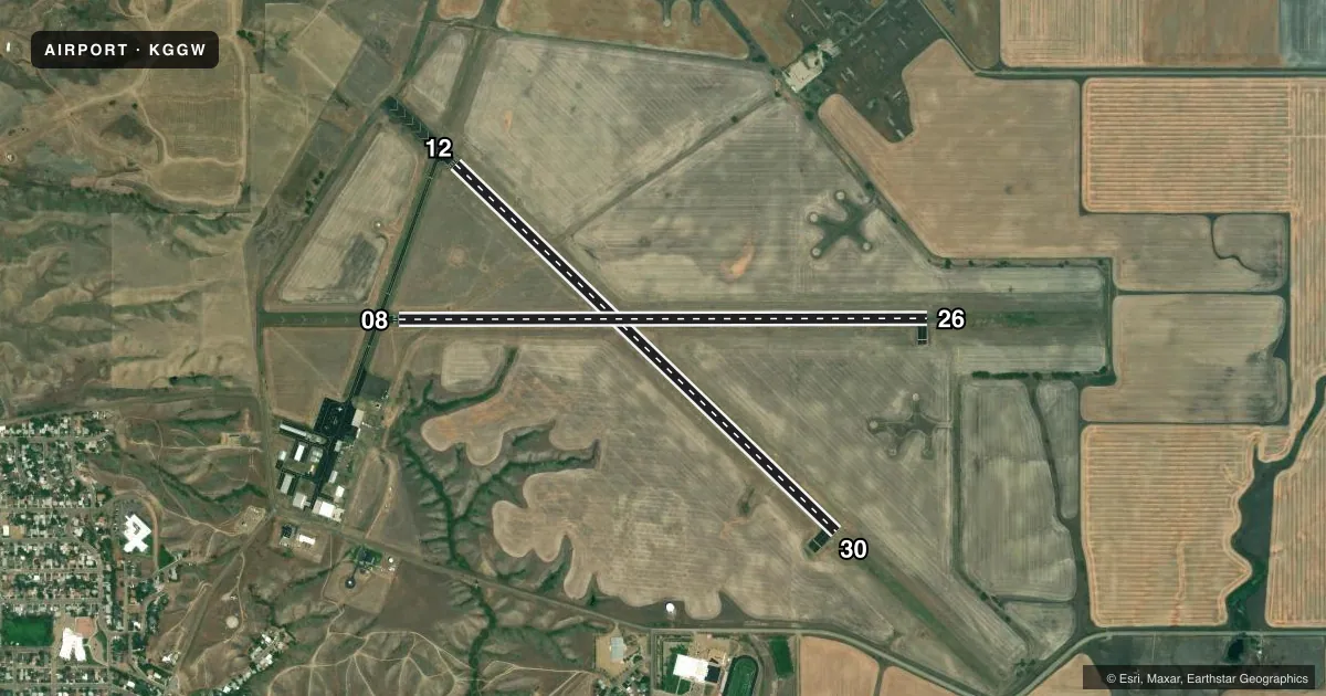
Runways & pattern
Full pagePattern entry · RWY 08
LEFT TRAFFIC| Runway | Heading (°M) | Length | Surface | Traffic |
|---|---|---|---|---|
| 12/30 | 123° / 303° | 5,002 ft | ASPH | Standard L |
| 08/26Favored | 79° / 259° | 5,000 ft | ASPH | Standard L |
Runway end performance
| End | TORA | TODA | ASDA | LDA | VGSI | Approach lights | Obstruction |
|---|---|---|---|---|---|---|---|
| 12 | 5,001' | 5,001' | 5,001' | 5,001' | PAPI 4-box left(3°) | — | — |
| 30 | 5,001' | 5,001' | 5,001' | 5,001' | PAPI 4-box left(3°) | — | — |
| 08 | 5,000' | 5,000' | 5,000' | 5,000' | PAPI 2-box left(3°) | — | — |
| 26 | 5,000' | 5,000' | 5,000' | 5,000' | PAPI 2-box left(3°) | — | — |
Declared distances in feet. TORA = takeoff run available, TODA = takeoff distance, ASDA = accelerate-stop, LDA = landing distance.
Airport sketch
Runways drawn to scale from FAA survey coordinates, rendered over satellite imagery. Not for navigation.
Approaches & charts
Services on the field
Fuel grades, oxygen, maintenance, ramp storage and lighting — as declared to the FAA by the airport operator.
Fuel & services
- Fuel
- 100LLA1+
- Oxygen (bottled)
- HIGH/LOW
- Oxygen (bulk)
- HIGH/LOW
- Airframe repair
- Major
- Power plant repair
- Major
- Other services
- AFRT,AGRI,AMB,CARGO,CHTR,INSTR,RNTL,SALES
Ramp & ground
- Transient storage
- Tie-down
- Hangar
- Landing fee
- No fee published
- Customs
- Not available
- Lighting schedule
- SEE RMK
- Beacon schedule
- SS-SR
- Beacon
- White / Green (civil land)(WG)
- Wind indicator
- Lighted
- Segmented circle
- Yes
Fuel & FBOs
Cheapest 100LL and Jet A on the field and nearby. Always confirm with the FBO before taxi.
Airport notes
Surface conditions, obstructions, local procedures, lighting outages and other notes published with each FAA cycle.
General notes
- FOR CD IF UNA TO CTC ON FSS FREQ, CTC SALT LAKE ARTCC AT 801-320-2568.
- SFC COND UNMON 2000-0600.
Lighting notes
- ACTVT REIL RWY 8, 12, 26, & 30; MIRL RWY 08/26 & 12/30 - CTAF. PAPI RWY 08, 12, 26, & 30 OPR CONSLY.
VFR map & nearby airports
VFR sectional. Tap any ICAO chip to open that airport.
Key facts · KGGW
Answer card- ICAO
- KGGW
- Name
- WOKAL FLD/GLASGOW-VALLEY COUNTY
- Location
- GLASGOW, MONTANA
- Elevation
- 2,295.9 ft MSL
- Traffic pattern altitude
- 3,295.9 ft MSL (1,000 AGL)
- Control tower
- Non-towered (use CTAF)
- Total runways
- 2
- Longest runway
- 12/30 · 5,002 ft
- Published ILS approaches
- 0
- Published frequencies
- 2
- Magnetic variation
- 11°
- Current flight rules
- VFR
- Current wind
- 100° at 7 kt
- Favored runway now
- RWY 08
WOKAL FLD/GLASGOW-VALLEY COUNTY sits in Glasgow, Montana. Field elevation is 2,295.9 ft MSL. The airport has two asphalt runways. The longest is runway 12/30 at 5,002 ft. Runway 08/26 is 5,000 ft. There is no control tower. CTAF and UNICOM are both 122.8.
No ILS approaches are published here. Pattern altitude is not published, so use the standard 1,000 ft AGL for light piston traffic unless the current Chart Supplement says otherwise. The field uses magnetic headings with 11° variation. That matters when you brief the runway numbers. It also matters for your wind correction.
Valley County Airport is on the field. It carries AVGAS 100LL and Jet A. Call them at (406) 228-2719 for current service details before arrival. Published remarks also note that runway end identifier lights are on runways 08, 12, 26 and 30. Medium intensity runway lights are on both runways and are controlled on CTAF. PAPI is available on all four runway ends. Surface condition is unmonitored from 2000 to 0600. If you need clearance delivery and cannot reach flight service, contact Salt Lake ARTCC at 801-320-2568.
For a first-time arrival, the big items are the non-towered setup, the high field elevation and the lack of published ILS. Plan your arrival with the current Chart Supplement. Expect to self-brief the runway lighting and surface condition.