METAR & TAF 4U6
4U6 does not publish a METAR.
Showing the nearest reporting station: KGDV (DAWSON COMMUNITY) · 35.0 NM away. Conditions at 4U6 may differ.
METAR · KGDV
Observed 04:56Z
KGDV 270456Z AUTO 04006KT 7SM CLR 26/06 A2991 RMK AO2 SLP099 T02560061 TSNO $
- Wind
- 040° @ 6 kt
- Visibility
- 7 SM
- Temp / Dew
- 26°C / 6°C
- Altimeter
- 29.91 inHg
- Clouds
- CLR
- Density alt
- 4,360 ft
- Ceiling
- Unlimited
- Rules
- VFR
Airport info & contacts
Manager on record, flight service, ARTCC, attendance schedule and pattern altitude — published by the FAA and refreshed every 28 days.
Location
- From city
- 1 NM E
- VFR sectional
- BILLINGS
- ARTCC
- ZLC · SALT LAKE CITY
- NOTAM facility
- GTF (NOTAM-D)
Airport manager
- Name
- JEFF SKYBERG
- Phone
- 406-485-2481
- Address
- BOX 336, CIRCLE MT 59215
Flight service · Hours
- FSS GTF
- GREAT FALLS1-800-WX-BRIEF
- Attendance
- MON-FRI · 0800-1700
Frequencies
Tap any row to copy the frequency to your clipboard.
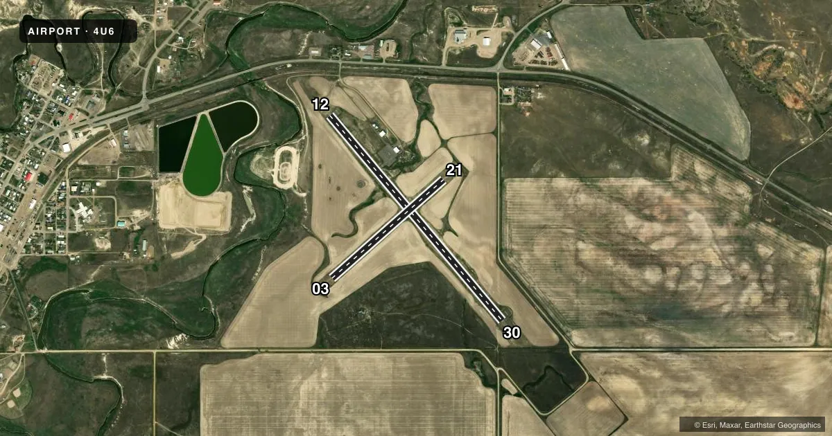
Runways & pattern
Full pagePattern entry · RWY 03
LEFT TRAFFIC| Runway | Heading (°M) | Length | Surface | Traffic |
|---|---|---|---|---|
| 12/30 | 131° / 311° | 4,100 ft | ASPH | Standard L |
| 03/21Favored | 39° / 220° | 2,280 ft | TURF | Standard L |
Runway end performance
| End | TORA | TODA | ASDA | LDA | VGSI | Approach lights | Obstruction |
|---|---|---|---|---|---|---|---|
| 12 | — | — | — | — | PAPI 2-box left(3°) | — | — |
| 30 | — | — | — | — | PAPI 2-box left(3°) | — | — |
Declared distances in feet. TORA = takeoff run available, TODA = takeoff distance, ASDA = accelerate-stop, LDA = landing distance.
Airport sketch
Runways drawn to scale from FAA survey coordinates, rendered over satellite imagery. Not for navigation.
Approaches & charts
Services on the field
Fuel grades, oxygen, maintenance, ramp storage and lighting — as declared to the FAA by the airport operator.
Fuel & services
- Fuel
- 100LL
- Oxygen (bottled)
- Not available
- Oxygen (bulk)
- Not available
- Airframe repair
- Major
- Power plant repair
- Major
- Other services
- AGRI
Ramp & ground
- Transient storage
- Tie-down
- Hangar
- Landing fee
- No fee published
- Customs
- Not available
- Lighting schedule
- SEE RMK
- Beacon schedule
- SS-SR
- Beacon
- White / Green (civil land)(WG)
- Wind indicator
- Lighted
- Segmented circle
- Yes
Fuel & FBOs
Cheapest 100LL and Jet A on the field and nearby. Always confirm with the FBO before taxi.
Airport notes
Surface conditions, obstructions, local procedures, lighting outages and other notes published with each FAA cycle.
General notes
- HAS -8 FT DRAINAGE DITCH 200 FT FM RY 03/21 THLDS.
- FOR CD CTC SALT LAKE ARTCC AT 801-320-2568.
Lighting notes
- ACTVT MIRL RY 12/30 & PAPI RY 12 AND RY 30 - CTAF.
Runway surface & condition
- 03/21CLSD WINTER MONTHS.
Approach & departure obstructions
- 0303/21 THRS MKD WITH RED CONES.
Other notes
- 03/21RWY IS RUF, WITH LONG GRASS, RWY EDGES ARE NOT MKD.
- 12/30TRANSVERSE CRACKS AT 100 FT INTVLS WITH SGFNT WID AND DPT.
- 03/21UNUSBL IN WET WEATHER.
VFR map & nearby airports
VFR sectional. Tap any ICAO chip to open that airport.
Key facts · 4U6
Answer card- ICAO
- 4U6
- Name
- CIRCLE TOWN COUNTY
- Location
- CIRCLE, MONTANA
- Elevation
- 2,441.4 ft MSL
- Traffic pattern altitude
- 3,441.4 ft MSL (1,000 AGL)
- Control tower
- Non-towered (use CTAF)
- Total runways
- 2
- Longest runway
- 12/30 · 4,100 ft
- Published ILS approaches
- 0
- Published frequencies
- 2
- Magnetic variation
- 9°
- Current flight rules
- VFR
- Current wind
- 040° at 6 kt
- Favored runway now
- RWY 03
Circle Town County Airport sits in Circle, Montana. The field elevation is 2,441.4 ft MSL. It has two runways. The longest is runway 12/30 at 4,100 ft. There is no control tower. CTAF and UNICOM are both 122.8. No ILS approaches are published, so plan with current VFR or non-ILS IFR options as applicable. Verify details before departure.
Pattern altitude is not published. Use the standard 1,000 ft AGL pattern unless the current Chart Supplement or local procedures say otherwise. Circle Aviation is on the field. It carries 100LL. Runway 12/30 has medium intensity lights. PAPI is activated on runways 12 and 30 by CTAF. The published remarks also call out transverse cracks on 12/30. Runway 03/21 is rough, has long grass and is unusable in wet weather. It is closed during winter months. Thresholds on 03/21 are marked with red cones. There is an 8-foot drainage ditch about 200 feet from the 03/21 thresholds.
For a first-time arrival, the big items are runway condition and surface choice. The asphalt runway is the practical option for most operations. Check the current Chart Supplement for any updated restrictions before you go. If you need clearance delivery, contact Salt Lake ARTCC at 801-320-2568.