METAR & TAF PO1
Current METAR
Observed 13:40Z
KPO1 271340Z AUTO 02009KT 9SM CLR 19/16 A2991 RMK AO2 TSNO
- Wind
- 020° @ 9 kt
- Visibility
- 9 SM
- Temp / Dew
- 19°C / 16°C
- Altimeter
- 29.91 inHg
- Clouds
- CLR
- Density alt
- 3,018 ft
- Ceiling
- Unlimited
- Rules
- VFR
Airport info & contacts
Manager on record, flight service, ARTCC, attendance schedule and pattern altitude — published by the FAA and refreshed every 28 days.
Location
- From city
- 2 NM NE
- VFR sectional
- BILLINGS
- ARTCC
- ZLC · SALT LAKE CITY
- NOTAM facility
- GTF (NOTAM-D)
Airport manager
- Name
- TRACY O'CONNOR
- Phone
- (406) 768-7400
- Address
- PO BOX 128, POPLAR MT 59255
Flight service · Hours
- FSS GTF
- GREAT FALLS1-800-WX-BRIEF
- Attendance
- MON-FRI · 0900-1700
Frequencies
Tap any row to copy the frequency to your clipboard.
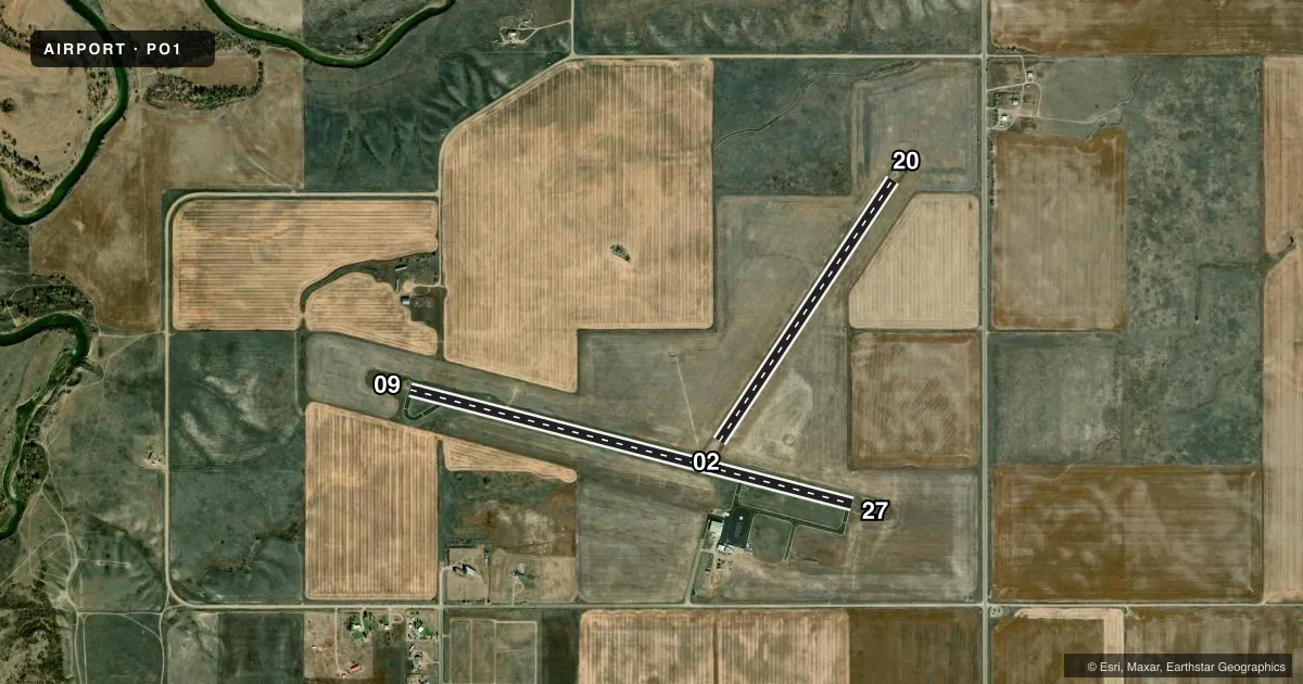
Runways & pattern
Full pagePattern entry · RWY 02
LEFT TRAFFIC| Runway | Heading (°M) | Length | Surface | Traffic |
|---|---|---|---|---|
| 09/27 | 95° / 275° | 4,403 ft | ASPH | Standard L |
| 02/20Favored | 25° / 205° | 3,020 ft | TURF | Standard L |
Runway end performance
| End | TORA | TODA | ASDA | LDA | VGSI | Approach lights | Obstruction |
|---|---|---|---|---|---|---|---|
| 09 | — | — | — | — | PAPI 2-box left(3°) | — | — |
| 27 | — | — | — | — | PAPI 2-box left(3°) | — | — |
Declared distances in feet. TORA = takeoff run available, TODA = takeoff distance, ASDA = accelerate-stop, LDA = landing distance.
Airport sketch
Runways drawn to scale from FAA survey coordinates, rendered over satellite imagery. Not for navigation.
Approaches & charts
Services on the field
Fuel grades, oxygen, maintenance, ramp storage and lighting — as declared to the FAA by the airport operator.
Fuel & services
- Fuel
- 100LLA+
- Other services
- AFRT,AGRI,AMB,CHTR,SURV
Ramp & ground
- Transient storage
- Hangar
- Lighting schedule
- SEE RMK
- Beacon schedule
- SS-SR
- Beacon
- White / Green (civil land)(WG)
- Wind indicator
- Yes
- Segmented circle
- Yes
Fuel & FBOs
Cheapest 100LL and Jet A on the field and nearby. Always confirm with the FBO before taxi.
Airport notes
Surface conditions, obstructions, local procedures, lighting outages and other notes published with each FAA cycle.
General notes
- FOR CURRENT ARPT SFC CONDITIONS CALL 406-768-7400.
- FOR CD CTC SALT LAKE ARTCC AT 801-320-2568.
Lighting notes
- ACTVT PAPI RYS 09 & 27 AND MIRL RY 09/27 - CTAF.
Fuel notes
- 100LL100LL SELF SVC AVBL 24/7.
- A+JET A AVBL ON REQ 406-768-3800.
Other notes
- MANAGEROR 406-768-7400
VFR map & nearby airports
VFR sectional. Tap any ICAO chip to open that airport.
Key facts · PO1
Answer card- ICAO
- PO1
- Name
- POPLAR MUNI
- Location
- POPLAR, MONTANA
- Elevation
- 2,037.1 ft MSL
- Traffic pattern altitude
- 3,037.1 ft MSL (1,000 AGL)
- Control tower
- Non-towered (use CTAF)
- Total runways
- 2
- Longest runway
- 09/27 · 4,403 ft
- Published ILS approaches
- 0
- Published frequencies
- 2
- Magnetic variation
- 9°
- Current flight rules
- VFR
- Current wind
- 020° at 9 kt
- Favored runway now
- RWY 02
Poplar Muni sits in Poplar, Montana. The field elevation is 2,037.1 ft MSL. It has two runways. The longest is runway 09/27 at 4,403 ft. Runway 02/20 is turf at 3,020 ft. There is no control tower. CTAF and UNICOM are both 122.8.
No ILS approaches are published here. Pattern altitude is not published, so a light piston pilot should plan on the standard 1,000 ft AGL unless the current Chart Supplement says otherwise. That puts the traffic pattern at about 3,037 ft MSL based on the field elevation. Check the current Chart Supplement before you go.
Dallas Aero & Sales is on the field. It carries 100LL and Jet A Prist. 100LL self-service is available 24 hours a day, 7 days a week. Jet A is available on request by calling the FBO. The published remarks also say PAPI and medium intensity runway lights are on runways 09 and 27. Use CTAF for traffic calls. For current airport surface conditions, call the airport manager at 406-768-7400. Clearance delivery is handled through Salt Lake ARTCC at 801-320-2568.
This is a non-towered field with a long asphalt runway. That makes it straightforward for VFR work. You still want to brief the pattern, winds and runway lighting before arrival.