METAR & TAF S85
S85 does not publish a METAR.
Showing the nearest reporting station: KSDY (SIDNEY-RICHLAND RGNL) · 29.6 NM away. Conditions at S85 may differ.
METAR · KSDY
Observed 04:56Z
KSDY 270456Z AUTO 35007KT 10SM CLR 23/09 A2989 RMK AO2 SLP105 T02330089 PNO $
- Wind
- 350° @ 7 kt
- Visibility
- 10 SM
- Temp / Dew
- 23°C / 9°C
- Altimeter
- 29.89 inHg
- Clouds
- CLR
- Density alt
- 3,419 ft
- Ceiling
- Unlimited
- Rules
- VFR
Airport info & contacts
Manager on record, flight service, ARTCC, attendance schedule and pattern altitude — published by the FAA and refreshed every 28 days.
Location
- From city
- 1 NM NE
- VFR sectional
- BILLINGS
- ARTCC
- ZLC · SALT LAKE CITY
- NOTAM facility
- GTF (NOTAM-D)
Airport manager
- Name
- ROBERT JASPER
- Phone
- 406-787-5271
- Address
- BOX 351, CULBERTSON MT 59218
Flight service · Hours
- FSS GTF
- GREAT FALLS1-800-WX-BRIEF
- Attendance
- Unattended
Frequencies
Tap any row to copy the frequency to your clipboard.
Runways & pattern
Full pagePattern entry · RWY 26
LEFT TRAFFICRunway end performance
| End | TORA | TODA | ASDA | LDA | VGSI | Approach lights | Obstruction |
|---|---|---|---|---|---|---|---|
| 26 | — | — | — | — | PAPI 2-box left(3°) | — | — |
Declared distances in feet. TORA = takeoff run available, TODA = takeoff distance, ASDA = accelerate-stop, LDA = landing distance.
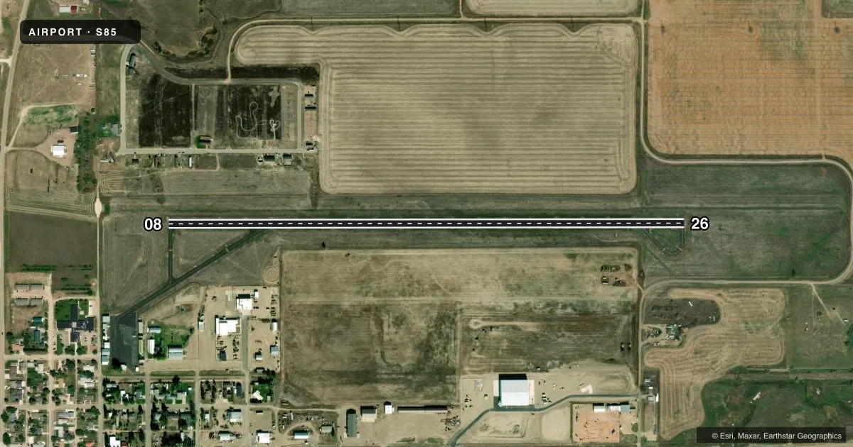
Airport sketch
Runways drawn to scale from FAA survey coordinates, rendered over satellite imagery. Not for navigation.
Approaches & charts
Services on the field
Fuel grades, oxygen, maintenance, ramp storage and lighting — as declared to the FAA by the airport operator.
Fuel & services
- Fuel
- 100LL
- Oxygen (bottled)
- Not available
- Oxygen (bulk)
- Not available
- Airframe repair
- Not available
- Power plant repair
- Not available
- Other services
- AGRI,AMB,SURV
Ramp & ground
- Transient storage
- Tie-down
- Landing fee
- No fee published
- Customs
- Not available
- Lighting schedule
- SEE RMK
- Beacon schedule
- SS-SR
- Beacon
- White / Green (civil land)(WG)
- Wind indicator
- Lighted
- Segmented circle
- Yes
Fuel & FBOs
Cheapest 100LL and Jet A on the field and nearby. Always confirm with the FBO before taxi.
Airport notes
Surface conditions, obstructions, local procedures, lighting outages and other notes published with each FAA cycle.
General notes
- FOR CD CTC SALT LAKE ARTCC AT 801-320-2568.
- 2,876 FT TWRS 3.5 MIS NW.
Lighting notes
- ACTVT MIRL RY 08/26 & PAPI RY 26 - CTAF.
Fuel notes
- 100LLSELF SERVICE CREDIT CARD 24/7
Other notes
- 2ON CALL ALL HOURS 406-787-6680/0660.
VFR map & nearby airports
VFR sectional. Tap any ICAO chip to open that airport.
Key facts · S85
Answer card- ICAO
- S85
- Name
- BIG SKY FLD
- Location
- CULBERTSON, MONTANA
- Elevation
- 1,953 ft MSL
- Traffic pattern altitude
- 2,953 ft MSL (1,000 AGL)
- Control tower
- Non-towered (use CTAF)
- Total runways
- 1
- Longest runway
- 08/26 · 3,800 ft
- Published ILS approaches
- 0
- Published frequencies
- 2
- Magnetic variation
- 13°
- Current flight rules
- VFR
- Current wind
- 350° at 7 kt
- Favored runway now
- RWY 26
Big Sky Fld is in Culbertson, Montana. The field elevation is 1,953 ft MSL. It has one runway, 08/26, which is 3,800 ft long and asphalt. The airport is non-towered. CTAF and UNICOM are both 122.8. No ILS approaches are published here.
The pattern altitude is not published. For light piston ops, plan on the standard 1,000 ft AGL unless the current Chart Supplement says otherwise. That puts the traffic pattern at 2,953 ft MSL. Self-serve 100LL is available 24 hours a day with a credit card. Airport services are on call at 406-787-6680 or 406-787-0660. Medium intensity runway lights serve runway 08/26. The PAPI on runway 26 is activated by CTAF.
This is a rural field with no tower, so keep your radio work tight and make your intentions clear. There are 2,876 ft towers 3.5 miles northwest of the airport. That matters for low-level maneuvering and for planning your departure and arrival path. For clearance delivery, contact Salt Lake ARTCC at 801-320-2568. Check the current Chart Supplement for any published noise or curfew restrictions before flying into the field.