METAR & TAF 48S
48S does not publish a METAR.
Showing the nearest reporting station: KHVR (HAVRE CITY-COUNTY) · 39.3 NM away. Conditions at 48S may differ.
METAR · KHVR
Observed 04:53Z
KHVR 270453Z AUTO 17003KT 4SM HZ OVC046 19/07 A2989 RMK AO2 SLP105 T01890072 $
- Wind
- 170° @ 3 kt
- Visibility
- 4 SM
- Temp / Dew
- 19°C / 7°C
- Altimeter
- 29.89 inHg
- Clouds
- OVC
- Density alt
- 3,795 ft
- Ceiling
- 4,600 ft AGL
- Rules
- MVFR
Airport info & contacts
Manager on record, flight service, ARTCC, attendance schedule and pattern altitude — published by the FAA and refreshed every 28 days.
Location
- From city
- 3 NM N
- VFR sectional
- BILLINGS
- ARTCC
- ZLC · SALT LAKE CITY
- NOTAM facility
- GTF (NOTAM-D)
Airport manager
- Name
- ROD WAGNER
- Phone
- (406) 580-7379
- Address
- PO BOX 427, HARLEM MT 59526
Flight service · Hours
- FSS GTF
- GREAT FALLS1-800-WX-BRIEF
- Attendance
- Unattended
Frequencies
Tap any row to copy the frequency to your clipboard.
Runways & pattern
Full pagePattern entry · RWY 15
LEFT TRAFFIC| Runway | Heading (°M) | Length | Surface | Traffic |
|---|---|---|---|---|
| 11/29 | 109° / 289° | 4,100 ft | ASPH | Standard L |
| 15/33Favored | 149° / 329° | 1,933 ft | TURF | Standard L |
Runway end performance
| End | TORA | TODA | ASDA | LDA | VGSI | Approach lights | Obstruction |
|---|---|---|---|---|---|---|---|
| 29 | — | — | — | — | PAPI 2-box left(3°) | — | — |
Declared distances in feet. TORA = takeoff run available, TODA = takeoff distance, ASDA = accelerate-stop, LDA = landing distance.
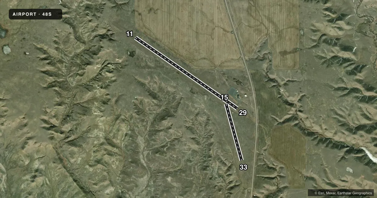
Airport sketch
Runways drawn to scale from FAA survey coordinates, rendered over satellite imagery. Not for navigation.
Approaches & charts
Services on the field
Fuel grades, oxygen, maintenance, ramp storage and lighting — as declared to the FAA by the airport operator.
Fuel & services
- Fuel
- Not available
- Oxygen (bottled)
- Not available
- Oxygen (bulk)
- Not available
- Airframe repair
- Not available
- Power plant repair
- Not available
- Other services
- AGRI
Ramp & ground
- Transient storage
- Tie-down
- Hangar
- Landing fee
- No fee published
- Lighting schedule
- SEE RMK
- Beacon schedule
- SS-SR
- Beacon
- White / Green (civil land)(WG)
- Wind indicator
- Lighted
- Segmented circle
- Yes
Fuel & FBOs
Cheapest 100LL and Jet A on the field and nearby. Always confirm with the FBO before taxi.
Airport notes
Surface conditions, obstructions, local procedures, lighting outages and other notes published with each FAA cycle.
General notes
- FOR CD CTC SALT LAKE ARTCC AT 801-320-2568.
Lighting notes
- ACTVT MIRL RY 11/29 & PAPI RY 29 - CTAF.
Approach & departure obstructions
- 15MKD WITH WHITE CONES SPACED 200 FT. MOST CONES MISG.
Other notes
- AGRITELEPHONES AVBL IN TERMINAL BLDG. PUSH BUTTON LOCK ON DOOR. KEY 122.9 TO ENTER BLDG.
- 15/33RWY 15/33 HAS LRG GOPHER HOLES AND TALL GRASS THRUT.
VFR map & nearby airports
VFR sectional. Tap any ICAO chip to open that airport.
Key facts · 48S
Answer card- ICAO
- 48S
- Name
- HARLEM
- Location
- HARLEM, MONTANA
- Elevation
- 2,643 ft MSL
- Traffic pattern altitude
- 3,643 ft MSL (1,000 AGL)
- Control tower
- Non-towered (use CTAF)
- Total runways
- 2
- Longest runway
- 11/29 · 4,100 ft
- Published ILS approaches
- 0
- Published frequencies
- 1
- Magnetic variation
- 16°
- Current flight rules
- MVFR
- Current wind
- 170° at 3 kt
- Favored runway now
- RWY 15
Harlem Airport sits in Harlem, Montana. The field elevation is 2,643 ft MSL. It has two runways. The longest is runway 11/29 at 4,100 ft on asphalt. Runway 15/33 is 1,933 ft on turf. There is no control tower. CTAF is 122.9.
No ILS approaches are published here. Pattern altitude is not published. For light piston traffic, use 1,000 ft AGL as the standard pattern reference unless the current Chart Supplement says otherwise. The airport sits in open country on the Hi-Line, so density altitude can matter on warm days at this elevation. Check performance before you go.
Published remarks matter here. Runway 11/29 has medium intensity lights. The PAPI on runway 29 is activated by CTAF. The terminal building has telephones. The door uses a push-button lock. Runway 15 is marked with white cones, though most cones are missing. Runway 15/33 has large gopher holes and tall grass throughout. That makes the turf runway a poor choice unless you have current field condition info. For clearance delivery, contact Salt Lake ARTCC at 801-320-2568. No on-field FBOs are listed, so verify fuel and services with the airport operator or call the field directly before arrival.