METAR & TAF 6U6
6U6 does not publish a METAR.
Showing the nearest reporting station: KHVR (HAVRE CITY-COUNTY) · 47.6 NM away. Conditions at 6U6 may differ.
METAR · KHVR
Observed 21:53Z
KHVR 262153Z AUTO 32009KT 4SM HZ SCT040 34/04 A2988 RMK AO2 SLP096 T03440039 $
- Wind
- 320° @ 9 kt
- Visibility
- 4 SM
- Temp / Dew
- 34°C / 4°C
- Altimeter
- 29.88 inHg
- Clouds
- SCT
- Density alt
- 6,222 ft
- Ceiling
- Unlimited
- Rules
- MVFR
Airport info & contacts
Manager on record, flight service, ARTCC, attendance schedule and pattern altitude — published by the FAA and refreshed every 28 days.
Location
- From city
- 1 NM NW
- VFR sectional
- BILLINGS
- ARTCC
- ZLC · SALT LAKE CITY
- NOTAM facility
- GTF (NOTAM-D)
Airport manager
- Name
- DOUG HAMILTON
- Phone
- (406) 390-1374
- Address
- 65 1ST AVE W, HOGELAND MT 59529
Flight service · Hours
- FSS GTF
- GREAT FALLS1-800-WX-BRIEF
- Attendance
- Unattended
Frequencies
Tap any row to copy the frequency to your clipboard.
Runways & pattern
Full pagePattern entry · RWY 34
LEFT TRAFFIC| Runway | Heading (°M) | Length | Surface | Traffic |
|---|---|---|---|---|
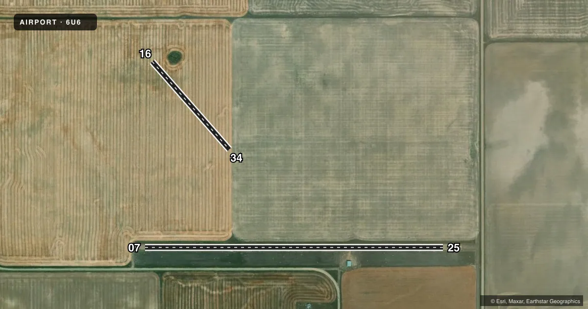
| 07/25 | 74° / 254° | 3,140 ft | GRVL-DIRT | Standard L |
| 16/34Favored | 123° / 303° | 1,230 ft | TURF | Standard L |
Runway end performance
| End | TORA | TODA | ASDA | LDA | VGSI | Approach lights | Obstruction |
|---|---|---|---|---|---|---|---|
| 34 | — | — | — | — | — | — | 21', bldg, 104' from thr, 86' R of cntrln, slope 4 |
Declared distances in feet. TORA = takeoff run available, TODA = takeoff distance, ASDA = accelerate-stop, LDA = landing distance.
Airport sketch
Runways drawn to scale from FAA survey coordinates, rendered over satellite imagery. Not for navigation.
Approaches & charts
Services on the field
Fuel grades, oxygen, maintenance, ramp storage and lighting — as declared to the FAA by the airport operator.
Fuel & services
- Fuel
- Not available
- Oxygen (bottled)
- Not available
- Oxygen (bulk)
- Not available
- Airframe repair
- Not available
- Power plant repair
- Not available
Ramp & ground
- Transient storage
- Tie-down
- Landing fee
- No fee published
- Customs
- Not available
- Wind indicator
- Yes
- Segmented circle
- No
Fuel & FBOs
Cheapest 100LL and Jet A on the field and nearby. Always confirm with the FBO before taxi.
Airport notes
Surface conditions, obstructions, local procedures, lighting outages and other notes published with each FAA cycle.
General notes
- FOR CD CTC SALT LAKE ARTCC AT 801-320-2568.
- POWER LINE LCTD 1,1000 FT FROM RWY34 END 40 FT TALL.
Other notes
- 16/34RWY 16/34 TALL GRASS, SLPD RWY.
VFR map & nearby airports
VFR sectional. Tap any ICAO chip to open that airport.
Key facts · 6U6
Answer card- ICAO
- 6U6
- Name
- HOGELAND
- Location
- HOGELAND, MONTANA
- Elevation
- 3,139 ft MSL
- Traffic pattern altitude
- 4,139 ft MSL (1,000 AGL)
- Control tower
- Non-towered (use CTAF)
- Total runways
- 2
- Longest runway
- 07/25 · 3,140 ft
- Published ILS approaches
- 0
- Published frequencies
- 1
- Magnetic variation
- 16°
- Current flight rules
- MVFR
- Current wind
- 320° at 9 kt
- Favored runway now
- RWY 34
Hogeland (6U6) is in Hogeland, Montana. The field elevation is 3,139 ft MSL. It has two runways. The longest is 07/25 at 3,140 ft on gravel-dirt. The other runway is 16/34 at 1,230 ft on turf. There is no control tower. CTAF is 122.9. No ILS approaches are published.
The pattern altitude is not published. Use the standard 1,000 ft AGL for light piston traffic unless the current Chart Supplement says otherwise. That puts the normal pattern reference at 4,139 ft MSL based on the field elevation. Verify before flight if you are operating anything nonstandard.
There are no on-field FBOs listed. Plan on self-sufficiency. Call the airport operator or the FBO directly if you need current services. Published remarks note a power line near the runway 34 end. The 16/34 runway also has tall grass and a slope. That makes the shorter turf strip a field to inspect carefully before use. The airport is uncontrolled, so expect self-announced traffic on CTAF. Coordinate your arrival with the current Chart Supplement if you need clearance delivery. Salt Lake ARTCC is listed for clearance delivery contact.