METAR & TAF 4V9
Current METAR
Observed 20:15Z
K4V9 112015Z AUTO 30021KT 10SM CLR 24/06 A2986 RMK AO2
- Wind
- 300° @ 21 kt
- Visibility
- 10 SM
- Temp / Dew
- 24°C / 6°C
- Altimeter
- 29.86 inHg
- Clouds
- CLR
- Density alt
- 3,354 ft
- Ceiling
- Unlimited
- Rules
- VFR
Airport info & contacts
Manager on record, flight service, ARTCC, attendance schedule and pattern altitude — published by the FAA and refreshed every 28 days.
Location
- From city
- 1 NM SW
- VFR sectional
- OMAHA
- ARTCC
- ZMP · MINNEAPOLIS
- NOTAM facility
- OLU (NOTAM-D)
Airport manager
Flight service · Hours
- FSS OLU
- COLUMBUS1-800-WX-BRIEF
- Attendance
- MON-FRI · 0800-1700
Frequencies
Tap any row to copy the frequency to your clipboard.
Runways & pattern
Full pagePattern entry · RWY 31
LEFT TRAFFIC| Runway | Heading (°M) | Length | Surface | Traffic |
|---|---|---|---|---|
| 01/19 | 8° / 188° | 3,700 ft | CONC | Standard L |
| 13/31Favored | 129° / 309° | 3,310 ft | CONC | Standard L |
Runway end performance
| End | TORA | TODA | ASDA | LDA | VGSI | Approach lights | Obstruction |
|---|---|---|---|---|---|---|---|
| 01 | — | — | — | — | PAPI 2-box left(3°) | — | — |
| 19 | — | — | — | — | PAPI 2-box left(3.5°) | — | — |
| 13 | 3,310' | 3,310' | 3,310' | 2,905' | — | — | 16', road, 239' from thr, 0' R of cntrln, slope 2 |
| 31 | 3,310' | 3,310' | 3,310' | 2,905' | — | — | 10', road, 201' from thr, 0' R of cntrln, slope 1 |
Declared distances in feet. TORA = takeoff run available, TODA = takeoff distance, ASDA = accelerate-stop, LDA = landing distance.
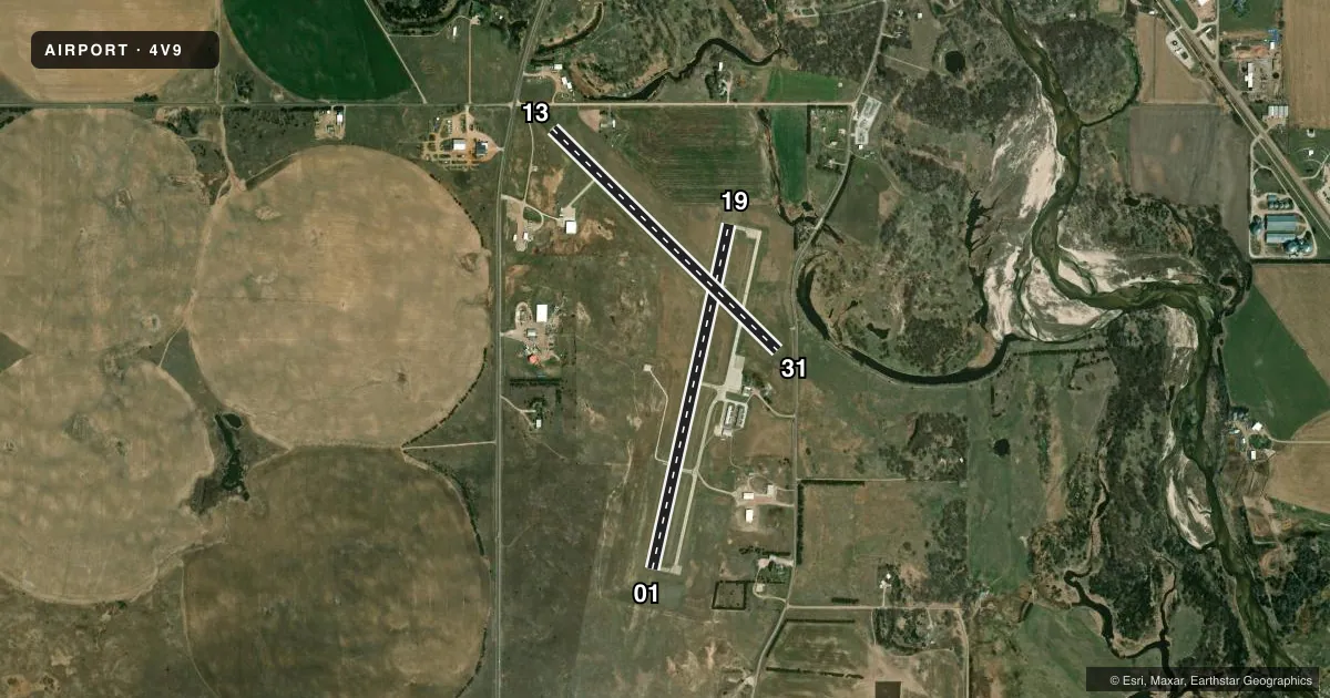
Airport sketch
Runways drawn to scale from FAA survey coordinates, rendered over satellite imagery. Not for navigation.
Approaches & charts
Services on the field
Fuel grades, oxygen, maintenance, ramp storage and lighting — as declared to the FAA by the airport operator.
Fuel & services
- Fuel
- 100LL
- Oxygen (bottled)
- Not available
- Oxygen (bulk)
- Not available
- Airframe repair
- Not available
- Power plant repair
- Not available
- Other services
- AGRI
Ramp & ground
- Transient storage
- Tie-down
- Hangar
- Landing fee
- No fee published
- Customs
- Not available
- Lighting schedule
- SEE RMK
- Beacon schedule
- SS-SR
- Beacon
- White / Green (civil land)(WG)
- Wind indicator
- Lighted
- Segmented circle
- No
Fuel & FBOs
Cheapest 100LL and Jet A on the field and nearby. Always confirm with the FBO before taxi.
Airport notes
Surface conditions, obstructions, local procedures, lighting outages and other notes published with each FAA cycle.
General notes
- UNICOM UNMON.
- FOR CD CTC MINNEAPOLIS ARTCC AT 651-463-5588.
- COURTESY CAR AVBL.
Lighting notes
- ACTVT PAPI RY 01/19; MIRL RY 01/19 - CTAF; AFT 2000 ACTVT MIRL RY 13/31 - CTAF.
Approach & departure obstructions
- 13RWY 13 6 FT FENCE 200 FT FM END, 90 FT R CONTN S.
- 31RWY 31 ROAD 169 FT FM END 89 FT R.
- 13RWY 13 ROAD 644 FT FM DSPLCD THR APCH RATIO 40:1.
- 31RWY 31 60 FT TREE 1754 FT FM DSPLCD THR 269 FT R APCH RATIO 29:1.
- 13RWY 13 ALSO WATCH SVC ROAD 350 FT FM END 39 FT R GOING S 200 FT FM END 125 FT R CONTG S.
Other notes
- NO HNGR SPACE FOR TSNT ACFT IN SUMMER. IN WINTER, HNGR SPACE AVAIL CALL 402-887-4827.
- MANAGERADDNL CTC: BRIAN WHITESEL 402-649-4172 OR JOE MCNALLY 402-650-2520. AUTHORITY CHAIRMAN IS RICK SCHINDLER, SAME CONTACT INFO AS OWNER
VFR map & nearby airports
VFR sectional. Tap any ICAO chip to open that airport.
Key facts · 4V9
Answer card- ICAO
- 4V9
- Name
- ANTELOPE COUNTY
- Location
- NELIGH, NEBRASKA
- Elevation
- 1,773.7 ft MSL
- Traffic pattern altitude
- 2,773.7 ft MSL (1,000 AGL)
- Control tower
- Non-towered (use CTAF)
- Total runways
- 2
- Longest runway
- 01/19 · 3,700 ft
- Published ILS approaches
- 0
- Published frequencies
- 2
- Magnetic variation
- 5°
- Current flight rules
- VFR
- Current wind
- 300° at 21 kt
- Favored runway now
- RWY 31
Antelope County Airport (4V9) sits near Neligh, Nebraska. Field elevation is 1,773.7 ft MSL. The airport has two concrete runways. The longest is 3,700 ft on runway 01/19. There is no control tower. CTAF and UNICOM are both 122.8. UNICOM is unmonitored.
No ILS approaches are published here. Pattern altitude is not published. Use the standard 1,000 ft AGL pattern unless the current Chart Supplement or local procedure says otherwise. The on-field FBO is Antelope County Airport. It carries 100LL. Call (402) 649-4172 for current service details.
A few runway notes matter here. Runway 13 has reported obstructions near the departure end, including a service road and a 6 ft fence. Runway 31 has a tree and a road near the approach end. Runway 01/19 has PAPI. Its medium intensity lights are activated on CTAF. After 2000, runway 13/31 lights are also activated on CTAF. For clearance delivery, contact Minneapolis ARTCC. Transient hangar space is not available in summer. It is available in winter. Call ahead if shelter matters. A courtesy car is available. First-time arrivals should pay close attention to the published obstruction notes. Plan for a non-towered arrival in a field with no published ILS.