METAR & TAF 4A5
4A5 does not publish a METAR.
Showing the nearest reporting station: KCCA (CLINTON MUNI) · 20.6 NM away. Conditions at 4A5 may differ.
METAR · KCCA
Observed 08:15Z
KCCA 120815Z AUTO 00000KT 9SM CLR 24/24 A2992 RMK AO2
- Wind
- 000° @ 0 kt
- Visibility
- 9 SM
- Temp / Dew
- 24°C / 24°C
- Altimeter
- 29.92 inHg
- Clouds
- CLR
- Density alt
- 2,275 ft
- Ceiling
- Unlimited
- Rules
- VFR
Airport info & contacts
Manager on record, flight service, ARTCC, attendance schedule and pattern altitude — published by the FAA and refreshed every 28 days.
Location
- From city
- 1 NM SW
- VFR sectional
- MEMPHIS
- ARTCC
- ZME · MEMPHIS
- NOTAM facility
- JBR (NOTAM-D)
Airport manager
- Name
- JOE WILSON, CHAIRMAN
- Phone
- 512-618-5331
- Address
- P.O. BOX 1033, MARSHALL AR 72650
Flight service · Hours
- FSS JBR
- JONESBORO1-800-WX-BRIEF
- Attendance
- Unattended
Frequencies
Tap any row to copy the frequency to your clipboard.
Runways & pattern
Full pagePattern entry · RWY 05
LEFT TRAFFICRunway end performance
| End | TORA | TODA | ASDA | LDA | VGSI | Approach lights | Obstruction |
|---|---|---|---|---|---|---|---|
| 05 | — | — | — | — | PAPI 2-box left(3.25°) | — | — |
| 23 | — | — | — | — | PAPI 2-box left(3.25°) | — | — |
Declared distances in feet. TORA = takeoff run available, TODA = takeoff distance, ASDA = accelerate-stop, LDA = landing distance.
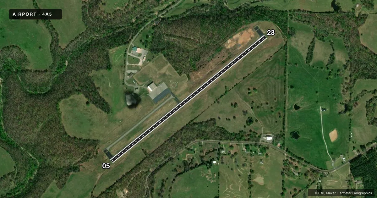
Airport sketch
Runways drawn to scale from FAA survey coordinates, rendered over satellite imagery. Not for navigation.
Approaches & charts
Services on the field
Fuel grades, oxygen, maintenance, ramp storage and lighting — as declared to the FAA by the airport operator.
Fuel & services
- Fuel
- 100LL
Ramp & ground
- Transient storage
- Tie-down
- Hangar
- Lighting schedule
- SEE RMK
- Beacon schedule
- SS-SR
- Beacon
- White / Green (civil land)(WG)
- Wind indicator
- Lighted
- Segmented circle
- Yes
Fuel & FBOs
Cheapest 100LL and Jet A on the field and nearby. Always confirm with the FBO before taxi.
Airport notes
Surface conditions, obstructions, local procedures, lighting outages and other notes published with each FAA cycle.
General notes
- LGTD TWR 2059 FT MSL/299 FT AGL ON MT TOP 1 MI E OF ARPT.
- DEER ON & INVOF ARPT.
- FOR CD CTC MEMPHIS ARTCC AT 901-368-8453/8449.
Lighting notes
- ACTVT REIL RWY 05 & 23; MIRL RWY 05/23 - CTAF.
Fuel notes
- 100LLSELF SVC AVBL H24 WITH CREDIT CARD.
Approach & departure obstructions
- 05RWY 05 REIL & PAPI OTS INDEFLY
- 23RWY 23 REIL & PAPI OTS INDEFLY
- 05PAPI UNUSBL 9 DEGS EACH SIDE OF CNTRLN.
- 23PAPI UNUSBL BYD 7 DEGS RIGHT OF CNTRLN.
Other notes
- PRVDD EXISTING SEARCY COUNTY ARPT CLSD PRIOR TO OPNS BEING CONDUCTED AT NEW ARPT.
VFR map & nearby airports
VFR sectional. Tap any ICAO chip to open that airport.
Key facts · 4A5
Answer card- ICAO
- 4A5
- Name
- SEARCY COUNTY
- Location
- MARSHALL, ARKANSAS
- Elevation
- 963.6 ft MSL
- Traffic pattern altitude
- 1,963.6 ft MSL (1,000 AGL)
- Control tower
- Non-towered (use CTAF)
- Total runways
- 1
- Longest runway
- 05/23 · 4,003 ft
- Published ILS approaches
- 0
- Published frequencies
- 1
- Magnetic variation
- 0°
- Current flight rules
- VFR
- Current wind
- 000° at 0 kt
- Favored runway now
- –
Searcy County Airport sits in Marshall, Arkansas. Field elevation is 963.6 ft MSL. The airport has one runway, 05/23, which is 4,003 ft long. There is no control tower. CTAF is 122.9. No ILS approaches are published here, so plan with the current chart and the weather you actually have.
Pattern altitude is not published. Use the standard 1,000 ft AGL pattern unless local procedures or current Chart Supplement remarks say otherwise. Runway lighting is CTAF-controlled on 05 and 23. The runway end identifier lights and PAPI on both ends are reported out of service indefinitely. The PAPI is also noted as unusable outside a limited centerline band on each end. Deer are reported on and near the airport. Keep a sharp scan on taxi, takeoff and landing.
Searcy County Airport has one on-field FBO. Searcy County Airport carries 100LL. Self-serve 100LL is available 24 hours with credit card. For clearance delivery, Memphis ARTCC is listed in the remarks. There is also a note about a lighted tower on the mountain top about 1 mile east of the airport. The field is a straightforward non-towered stop. The terrain and wildlife make it worth flying a disciplined pattern and a careful final.