METAR & TAF 1A5
Current METAR
Observed 06:55Z
K1A5 120655Z AUTO 00000KT 7SM CLR 19/19 A3013 RMK AO2 T01890186
- Wind
- 000° @ 0 kt
- Visibility
- 7 SM
- Temp / Dew
- 19°C / 19°C
- Altimeter
- 30.13 inHg
- Clouds
- CLR
- Density alt
- 2,742 ft
- Ceiling
- Unlimited
- Rules
- VFR
Airport info & contacts
Manager on record, flight service, ARTCC, attendance schedule and pattern altitude — published by the FAA and refreshed every 28 days.
Location
- From city
- 3 NM NW
- VFR sectional
- ATLANTA
- Pattern altitude
- 780 ft AGL · 2,814 ft MSL
- ARTCC
- ZTL · ATLANTA
- NOTAM facility
- RDU (NOTAM-D)
Airport manager
- Name
- SABRINA CRONE
- Phone
- 828-524-5529
- Address
- 1241 AIRPORT ROAD, FRANKLIN NC 28734-1513
Flight service · Hours
- FSS RDU
- RALEIGH1-800-WX-BRIEF
- Attendance
- 0800-1830
Frequencies
Tap any row to copy the frequency to your clipboard.
Runways & pattern
Full pagePattern entry · RWY 07
LEFT TRAFFICRunway end performance
| End | TORA | TODA | ASDA | LDA | VGSI | Approach lights | Obstruction |
|---|---|---|---|---|---|---|---|
| 07 | — | — | — | — | PAPI 2-box left(3°) | — | 89', trees, 2398' from thr, 33' R of cntrln, slope 24 |
| 25 | — | — | — | — | PAPI 2-box left(3°) | — | 12', trees, 215' from thr, 46' R of cntrln, slope 1 |
Declared distances in feet. TORA = takeoff run available, TODA = takeoff distance, ASDA = accelerate-stop, LDA = landing distance.
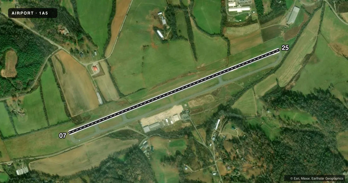
Airport sketch
Runways drawn to scale from FAA survey coordinates, rendered over satellite imagery. Not for navigation.
Approaches & charts
Services on the field
Fuel grades, oxygen, maintenance, ramp storage and lighting — as declared to the FAA by the airport operator.
Fuel & services
- Fuel
- 100LLA1+
- Oxygen (bottled)
- Not available
- Oxygen (bulk)
- Not available
- Airframe repair
- Major
- Power plant repair
- Major
- Other services
- INSTR,RNTL
Ramp & ground
- Transient storage
- Tie-down
- Hangar
- Landing fee
- No fee published
- Customs
- Not available
- Lighting schedule
- SEE RMK
- Beacon schedule
- SS-SR
- Beacon
- White / Green (civil land)(WG)
- Wind indicator
- Lighted
- Segmented circle
- Yes
Fuel & FBOs
Cheapest 100LL and Jet A on the field and nearby. Always confirm with the FBO before taxi.
Airport notes
Surface conditions, obstructions, local procedures, lighting outages and other notes published with each FAA cycle.
General notes
- RPDLY RSG TRRN ALL QUADS.
- RWY 25 HAS A 15 FT DROP-OFF 350 FT FM THR L & R.
- FOR CD CTC ATLANTA ARTCC AT 770-210-7692.
- COLD TEMPERATURE AIRPORT. ALTITUDE CORRECTION REQUIRED AT OR BELOW -11C.
Lighting notes
- ARPT BCN LCTD 3/4 MILE SE OF ARPT.
- PAPI RWY 07 & 25; MIRL RWY 07/25 ON DUSK - DAWN. TO INCR INTST - CTAF.
Fuel notes
- 100LL100LL AND JET A 24 HR SELF-SERVICE WITH CREDIT CARD.
Approach & departure obstructions
- 076 FT HILL 0-200 FT FM END OF THLD OFFSET 100 FT LEFT OF CNTRLN AND 29 FT TREES 56 FT FM END OF THLD OFFSET 227 FT LEFT.
- 25RWY 25 8 FT FENCE 159 FT FM END OF THR OFFSET 134 FT RIGHT OF CNTRLN AND 10 FT BRUSH 0 TO 200 FT FM THR OFFSET 168 FT LEFT OF CNTRLN.
- 07PAPI RWY 7 OTS INDEFLY.
- 25PAPI RWY 25 OTS INDEFLY.
Other notes
- 1AFLD SVC AVBL 0800-1830 EXCLD HOL.
VFR map & nearby airports
VFR sectional. Tap any ICAO chip to open that airport.
Key facts · 1A5
Answer card- ICAO
- 1A5
- Name
- MACON COUNTY
- Location
- FRANKLIN, NORTH CAROLINA
- Elevation
- 2,033.9 ft MSL
- Traffic pattern altitude
- 2,813.9 ft MSL (780 AGL)
- Control tower
- Non-towered (use CTAF)
- Total runways
- 1
- Longest runway
- 07/25 · 5,002 ft
- Published ILS approaches
- 0
- Published frequencies
- 2
- Magnetic variation
- 5°
- Current flight rules
- VFR
- Current wind
- 000° at 0 kt
- Favored runway now
- –
Macon County Airport is in Franklin, North Carolina. The field elevation is 2,033.9 ft MSL. It has one runway, 07/25, which is 5,002 ft long. There is no control tower. CTAF and UNICOM are both 123.05. No ILS approaches are published here.
Pattern altitude is 780 ft AGL, which is 2,813.9 ft MSL. Macon Air is on the field. It carries 100LL and Jet A. Fuel is available 24 hours self-service with a credit card. Airfield service is listed from 0800 to 1830, excluding holidays. The airport is in the mountains. Published remarks call out rapidly rising terrain in all quadrants. That matters on departure and arrival, especially when density altitude is high.
There are a few runway notes to plan around. Runway 07 has trees and a small hill near the departure end. Runway 25 has a fence and brush near the threshold. Both PAPI systems are out of service indefinitely. Medium intensity runway lights and the PAPIs are listed as operating from dusk to dawn, with intensity increased by using CTAF. For clearance delivery, contact Atlanta ARTCC at 770-210-7692. This is also a cold temperature airport. Altitude correction is required at or below minus 11 degrees Celsius.