METAR & TAF 0W3
Current METAR
Observed 17:15Z
K0W3 271715Z AUTO 02003KT 10SM CLR 29/19 A2984 RMK AO2 T02890186 $
- Wind
- 020° @ 3 kt
- Visibility
- 10 SM
- Temp / Dew
- 29°C / 19°C
- Altimeter
- 29.84 inHg
- Clouds
- CLR
- Density alt
- 2,290 ft
- Ceiling
- Unlimited
- Rules
- VFR
Airport info & contacts
Manager on record, flight service, ARTCC, attendance schedule and pattern altitude — published by the FAA and refreshed every 28 days.
Location
- From city
- 3 NM E
- VFR sectional
- WASHINGTON
- ARTCC
- ZDC · WASHINGTON
- NOTAM facility
- DCA (NOTAM-D)
Airport manager
- Name
- KEVIN HESS
- Phone
- 410-836-2828
- Address
- 3538 ALDINO RD, HANGAR 9, CHURCHVILLE MD 21028
Flight service · Hours
- FSS DCA
- LEESBURG1-800-WX-BRIEF
- Attendance
- 1300Z++-DUSK
Frequencies
Tap any row to copy the frequency to your clipboard.
Runways & pattern
Full pagePattern entry · RWY 01
LEFT TRAFFICRunway end performance
| End | TORA | TODA | ASDA | LDA | VGSI | Approach lights | Obstruction |
|---|---|---|---|---|---|---|---|
| 01 | — | — | — | — | PAPI 2-box left(3.5°) | — | 20', pline, 389' from thr, 13' R of cntrln, slope 9 |
| 19 | — | — | — | — | PAPI 2-box left(3.25°) | — | — |
Declared distances in feet. TORA = takeoff run available, TODA = takeoff distance, ASDA = accelerate-stop, LDA = landing distance.
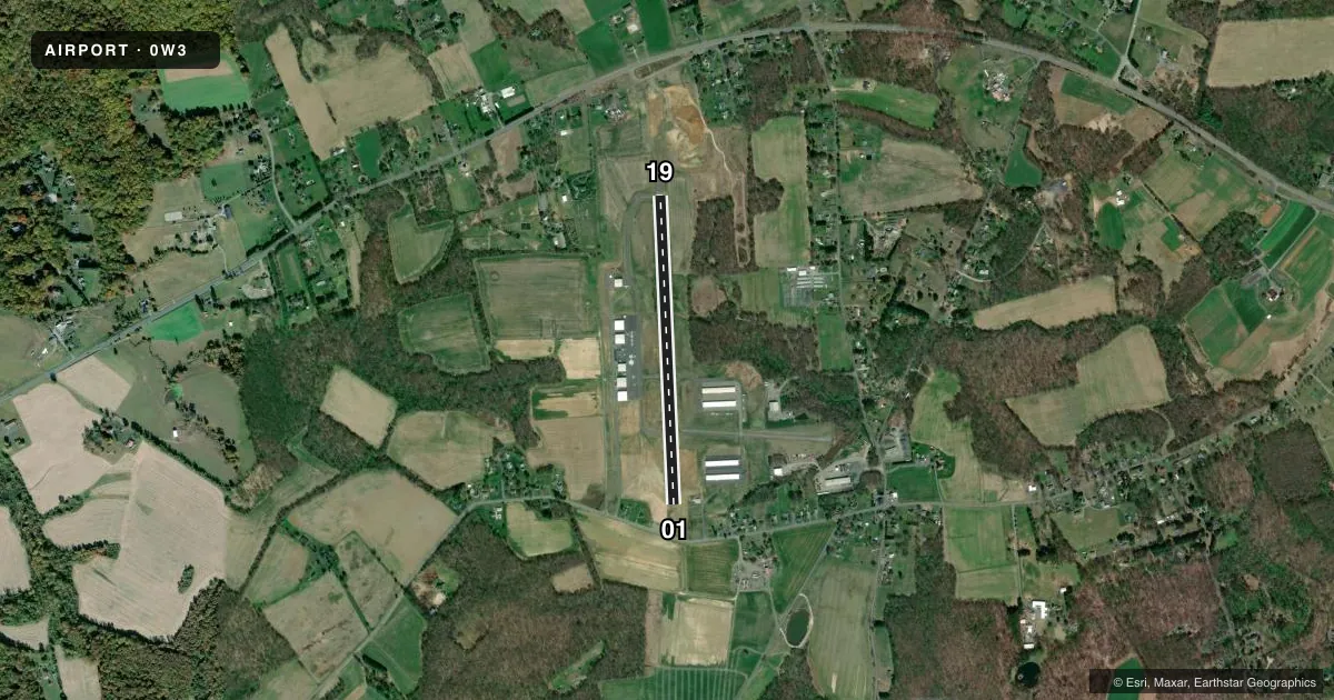
Airport sketch
Runways drawn to scale from FAA survey coordinates, rendered over satellite imagery. Not for navigation.
Approaches & charts
Services on the field
Fuel grades, oxygen, maintenance, ramp storage and lighting — as declared to the FAA by the airport operator.
Fuel & services
- Fuel
- 100LLA
- Oxygen (bottled)
- Not available
- Oxygen (bulk)
- Not available
- Airframe repair
- Major
- Power plant repair
- Major
- Other services
- GLD,INSTR,PAJA,RNTL,TOW
Ramp & ground
- Transient storage
- Tie-down
- Landing fee
- No fee published
- Customs
- Not available
- Lighting schedule
- SEE RMK
- Beacon schedule
- SEE RMK
- Beacon
- White / Green (civil land)(WG)
- Wind indicator
- Lighted
- Segmented circle
- No
Fuel & FBOs
Cheapest 100LL and Jet A on the field and nearby. Always confirm with the FBO before taxi.
Airport notes
Surface conditions, obstructions, local procedures, lighting outages and other notes published with each FAA cycle.
General notes
- BIRDS AND WILDLIFE ON & INVOF ARPT.
- FOR CD CTC POTOMAC APCH AT 866-429-5882.
- CAUTION PAJA AND GLDR OPS ON ARPT.
Lighting notes
- DUSK-0100.
- ACTVT REIL RWY 01 & 19; PAPI RWY 01 & 19; MIRL RWY 01/19 - CTAF.
Other notes
- EXISTED PRIOR TO 1959.
VFR map & nearby airports
VFR sectional. Tap any ICAO chip to open that airport.
Key facts · 0W3
Answer card- ICAO
- 0W3
- Name
- HARFORD COUNTY
- Location
- CHURCHVILLE, MARYLAND
- Elevation
- 411.6 ft MSL
- Traffic pattern altitude
- 1,411.6 ft MSL (1,000 AGL)
- Control tower
- Non-towered (use CTAF)
- Total runways
- 1
- Longest runway
- 01/19 · 3,354 ft
- Published ILS approaches
- 0
- Published frequencies
- 4
- Magnetic variation
- 11°
- Current flight rules
- VFR
- Current wind
- 020° at 3 kt
- Favored runway now
- RWY 01
Harford County Airport sits in Churchville, Maryland. Field elevation is 411.6 ft MSL. The airport has one runway. Runway 01/19 is 3,354 ft of asphalt, so it is the main runway to plan around. There is no control tower. Potomac Approach handles clearance delivery and approach services. The published frequencies include CTAF and UNICOM on 122.8, plus Potomac on 125.525 and 291.625.
No ILS approaches are published here. Pattern altitude is not published, so use the standard 1,000 ft AGL for light piston operations unless the current FAA Chart Supplement says otherwise. The beacon operates from dusk to 0100. Runway end identifier lights are available on 01 and 19. PAPI is also available on both ends. Medium intensity runway lights are on 01/19 and are controlled by the common traffic advisory frequency.
Harford Air Services is on the field. It carries 100LL and Jet A. Wildlife is a real factor here. Birds are published in the area. Powered parachute and glider operations also occur on the airport, so keep your scan wide in the pattern and on final. If you are new to the field, get current notes from the FAA Chart Supplement before you go.