METAR & TAF W78
Current METAR
Observed 05:15Z
KW78 120515Z AUTO 26004KT 10SM CLR 26/20 A2988 RMK AO1 T02560200
- Wind
- 260° @ 4 kt
- Visibility
- 10 SM
- Temp / Dew
- 26°C / 20°C
- Altimeter
- 29.88 inHg
- Clouds
- CLR
- Density alt
- 1,890 ft
- Ceiling
- Unlimited
- Rules
- VFR
Airport info & contacts
Manager on record, flight service, ARTCC, attendance schedule and pattern altitude — published by the FAA and refreshed every 28 days.
Location
- From city
- 3 NM E
- VFR sectional
- WASHINGTON
- Pattern altitude
- 800 ft AGL · 1,220 ft MSL
- ARTCC
- ZDC · WASHINGTON
- NOTAM facility
- DCA (NOTAM-D)
Airport manager
- Name
- JASON JOHNSON
- Phone
- 434-476-3300
- Address
- PO BOX 699, HALIFAX VA 24558
Flight service · Hours
- FSS DCA
- LEESBURG1-800-WX-BRIEF
- Attendance
- UNATTENDED
Frequencies
Tap any row to copy the frequency to your clipboard.
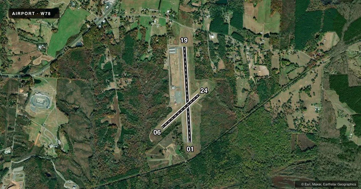
Runways & pattern
Full pagePattern entry · RWY 24
LEFT TRAFFIC| Runway | Heading (°M) | Length | Surface | Traffic |
|---|---|---|---|---|
| 01/19 | 349° / 169° | 4,003 ft | ASPH | Standard L |
| 06/24Favored | 40° / 220° | 2,065 ft | TURF | Standard L |
Runway end performance
| End | TORA | TODA | ASDA | LDA | VGSI | Approach lights | Obstruction |
|---|---|---|---|---|---|---|---|
| 01 | — | — | — | — | PAPI 2-box left(3°) | — | 28', trees, 481' from thr, 265' R of cntrln, slope 10 |
| 19 | — | — | — | — | PAPI 2-box left(3°) | — | 42', tree, 861' from thr, 100' R of cntrln, slope 15 |
| 06 | — | — | — | — | — | — | 69', trees, 1134' from thr, 143' R of cntrln, slope 13 |
| 24 | — | — | — | — | — | — | 70', trees, 891' from thr, 70' R of cntrln, slope 9 |
Declared distances in feet. TORA = takeoff run available, TODA = takeoff distance, ASDA = accelerate-stop, LDA = landing distance.
Airport sketch
Runways drawn to scale from FAA survey coordinates, rendered over satellite imagery. Not for navigation.
Approaches & charts
Services on the field
Fuel grades, oxygen, maintenance, ramp storage and lighting — as declared to the FAA by the airport operator.
Fuel & services
- Fuel
- 100LL
- Oxygen (bottled)
- Not available
- Oxygen (bulk)
- Not available
- Airframe repair
- Minor
- Power plant repair
- Minor
- Other services
- INSTR
Ramp & ground
- Transient storage
- Tie-down
- Landing fee
- No fee published
- Customs
- Not available
- Lighting schedule
- SEE RMK
- Beacon schedule
- SS-SR
- Beacon
- White / Green (civil land)(WG)
- Wind indicator
- Lighted
- Segmented circle
- No
Fuel & FBOs
Cheapest 100LL and Jet A on the field and nearby. Always confirm with the FBO before taxi.
Airport notes
Surface conditions, obstructions, local procedures, lighting outages and other notes published with each FAA cycle.
General notes
- WILDLIFE ON & INVOF RYS.
- SELF-FUELING WITH A CREDIT CARD.
- RWY 06/24 CLSD TO ACFT WITH AIRSPEED 50 KT OR MORE.
- FOR CD CTC WASHINGTON ARTCC AT 703-771-3587.
Lighting notes
- ACTVT MIRL RY 01/19 & REIL RYS 01 & 19 - CTAF. PAPI RYS 01 & 19 OPER CONT.
Approach & departure obstructions
- 015 FT BRUSH 150 FT LEFT AND RIGHT OF RWY CNTRLN.
- 06RY 06 OUTLINED WITH YELLOW CONES.
- 24RY 24 OUTLINED WITH YELLOW CONES.
Other notes
- IN OPERATION PRIOR 1959
VFR map & nearby airports
VFR sectional. Tap any ICAO chip to open that airport.
Key facts · W78
Answer card- ICAO
- W78
- Name
- WILLIAM M TUCK
- Location
- SOUTH BOSTON, VIRGINIA
- Elevation
- 419.8 ft MSL
- Traffic pattern altitude
- 1,219.8 ft MSL (800 AGL)
- Control tower
- Non-towered (use CTAF)
- Total runways
- 2
- Longest runway
- 01/19 · 4,003 ft
- Published ILS approaches
- 0
- Published frequencies
- 2
- Magnetic variation
- 8°
- Current flight rules
- VFR
- Current wind
- 260° at 4 kt
- Favored runway now
- RWY 24
William M Tuck Airport sits in South Boston, Virginia. Field elevation is 419.8 ft MSL. The airport has two runways. The longest is runway 01/19 at 4,003 ft. There is no control tower. CTAF and UNICOM are both 122.8. No ILS approaches are published here.
Pattern altitude is 800 ft AGL, which is 1,219.8 ft MSL. The on-field FBO is William M. Tuck Airport. It carries 100LL. Self-fueling is available with a credit card. That is useful to know if you are planning a quick stop.
Runway 01/19 is the main paved strip. Medium intensity runway lights are activated by CTAF on 01 and 19. REILs are also on 01 and 19. PAPI is available on those same runways and operates continuously. Runway 06/24 is turf at 2,065 ft. It is closed to aircraft with airspeed 50 knots or more. Runway 06 and runway 24 are outlined with yellow cones.
First-time arrivals should pay attention to wildlife on and near the runways. Brush 5 ft high sits 150 ft left and right of the centerline on runway 01. The field uses 8° magnetic variation. For clearance delivery, contact Washington ARTCC at 703-771-3587. This is a non-towered airport, so standard self-announce procedures on CTAF matter here.