METAR & TAF S21
Current METAR
Observed 16:15Z
KS21 271615Z AUTO 15005KT 10SM CLR 16/09 A3020 RMK AO2
- Wind
- 150° @ 5 kt
- Visibility
- 10 SM
- Temp / Dew
- 16°C / 9°C
- Altimeter
- 30.20 inHg
- Clouds
- CLR
- Density alt
- 4,936 ft
- Ceiling
- Unlimited
- Rules
- VFR
Airport info & contacts
Manager on record, flight service, ARTCC, attendance schedule and pattern altitude — published by the FAA and refreshed every 28 days.
Location
- From city
- 1 NM W
- VFR sectional
- KLAMATH FALLS
- ARTCC
- ZSE · SEATTLE
- NOTAM facility
- MMV (NOTAM-D)
Airport manager
- Name
- BRANDON WRIGHT
- Phone
- 541-593-4603
- Address
- 57200 RIVER ROAD, SUNRIVER OR 97707
Flight service · Hours
- FSS MMV
- MC MINNVILLE1-800-WX-BRIEF
- Attendance
- MAY 15 - 14 OCT · 0700-1900
- 15 OCT - 14 MAY · 0800-1800
Frequencies
Tap any row to copy the frequency to your clipboard.
Runways & pattern
Full pagePattern entry · RWY 18
RIGHT TRAFFICRunway end performance
| End | TORA | TODA | ASDA | LDA | VGSI | Approach lights | Obstruction |
|---|---|---|---|---|---|---|---|
| 18 | — | — | — | — | PAPI 4-box left(3.5°) | — | — |
| 36 | — | — | — | — | PAPI 4-box left(3.5°) | — | 80', trees, 2000' from thr, 150' R of cntrln, slope 22 |
Declared distances in feet. TORA = takeoff run available, TODA = takeoff distance, ASDA = accelerate-stop, LDA = landing distance.
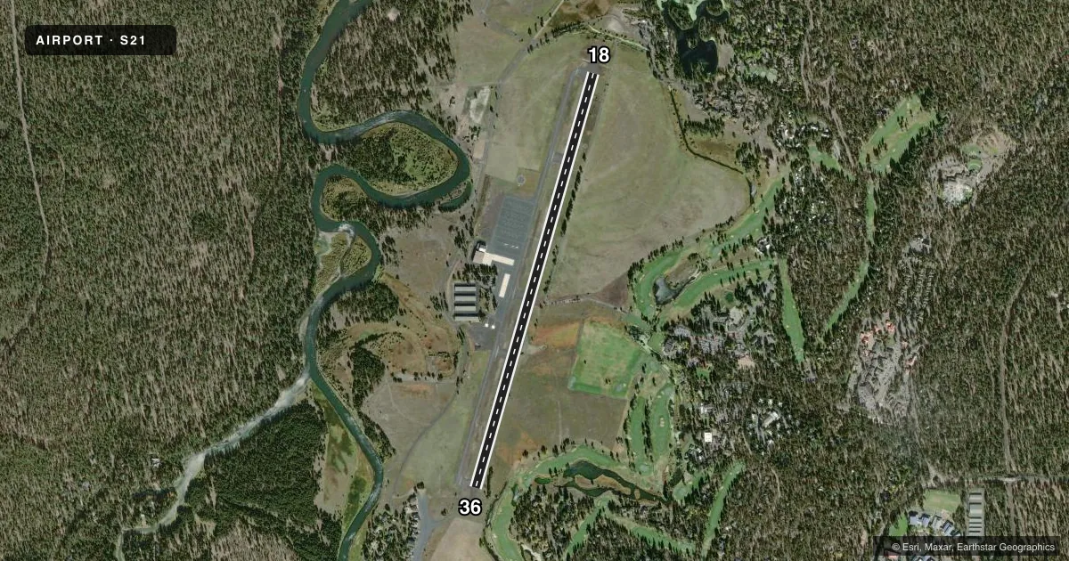
Airport sketch
Runways drawn to scale from FAA survey coordinates, rendered over satellite imagery. Not for navigation.
Approaches & charts
Services on the field
Fuel grades, oxygen, maintenance, ramp storage and lighting — as declared to the FAA by the airport operator.
Fuel & services
- Fuel
- 100LLAA+
- Oxygen (bottled)
- Not available
- Oxygen (bulk)
- Not available
- Power plant repair
- Not available
- Other services
- GLD,TOW
Ramp & ground
- Transient storage
- Tie-down
- Hangar
- Landing fee
- No fee published
- Customs
- Not available
- Lighting schedule
- SEE RMK
- Beacon schedule
- SEE RMK
- Beacon
- White / Green (civil land)(WG)
- Wind indicator
- Lighted
- Segmented circle
- Yes
Fuel & FBOs
Cheapest 100LL and Jet A on the field and nearby. Always confirm with the FBO before taxi.
Airport notes
Surface conditions, obstructions, local procedures, lighting outages and other notes published with each FAA cycle.
General notes
- FOR NOISE ABATEMENT DEPARTING ACFT ARE URGED TO CLIMB WEST OF ARPT PRIOR TO TURNING ON COURSE.
- FLOCKS OF WATERFOWL INVOF ARPT.
- FOR CD IF UNA TO CTC ON FSS FREQ, CTC SEATTLE ARTCC AT 253-351-3694.
Lighting notes
- ACTVT ROTG BCN - CTAF.
- ACTVT REIL RWY 18 & 36; PAPI RWY 18 & 36; MIRL RWY 18/36 - CTAF.
Approach & departure obstructions
- 36THRESHOLD LIGHTS LOCATED 148 FT NORTH OF ACTUAL RUNWAY END
- 18RWY 18 APCH RATIO 54:1 BASED ON DSPLCD THLD; +70 FT TREES 4000 FT ON CNTRLN.
VFR map & nearby airports
VFR sectional. Tap any ICAO chip to open that airport.
Key facts · S21
Answer card- ICAO
- S21
- Name
- SUNRIVER
- Location
- SUNRIVER, OREGON
- Elevation
- 4,163.5 ft MSL
- Traffic pattern altitude
- 5,163.5 ft MSL (1,000 AGL)
- Control tower
- Non-towered (use CTAF)
- Total runways
- 1
- Longest runway
- 18/36 · 5,460 ft
- Published ILS approaches
- 0
- Published frequencies
- 2
- Magnetic variation
- 14°
- Current flight rules
- VFR
- Current wind
- 150° at 5 kt
- Favored runway now
- RWY 18
Sunriver Airport sits in Sunriver, Oregon. The field elevation is 4,163.5 ft MSL. It has one runway, 18/36, which is 5,460 ft long and asphalt. There is no control tower. CTAF and UNICOM are both 122.8. No ILS approaches are published here.
The published pattern altitude is not listed. Use the standard 1,000 ft AGL pattern unless the current Chart Supplement says otherwise. That puts you at about 5,163.5 ft MSL. Sunriver Resort is on the field. It carries 100LL, Jet A and Jet A Prist. Call (541) 593-4603 for current fuel and ramp details.
This is a high-elevation airport, so density altitude matters. Expect a longer takeoff roll than you would at a low field. The published remarks also call out waterfowl near the airport. Departing aircraft are urged to climb west of the airport before turning on course for noise abatement. Runway lighting is pilot-controlled on CTAF. The runway 18 approach also has a published tree obstruction note. Check the current Chart Supplement before you go, especially if you plan a night arrival or want the latest lighting and obstruction details.