METAR & TAF PAJN
Current METAR
Observed 00:53Z
PAJN 280053Z 00000KT 10SM -RA SCT005 BKN021 OVC041 13/11 A3004
- Wind
- 000° @ 0 kt
- Visibility
- 10 SM
- Temp / Dew
- 13°C / 11°C
- Altimeter
- 30.04 inHg
- Clouds
- OVC
- Density alt
- -357 ft
- Ceiling
- 2,100 ft AGL
- Rules
- MVFR
Airport info & contacts
Manager on record, flight service, ARTCC, attendance schedule and pattern altitude — published by the FAA and refreshed every 28 days.
Location
- From city
- 7 NM NW
- VFR sectional
- JUNEAU
- ARTCC
- ZAN · ANCHORAGE
- NOTAM facility
- JNU (NOTAM-D)
Airport manager
- Name
- ANDRES DELGADO
- Phone
- 907-789-7821
- Address
- 1873 SHELL SIMMONS DR, SUITE 200, JUNEAU AK 99801
Flight service · Hours
- FSS JNU
- JUNEAU907-586-73801-866-297-2236
- Attendance
- ALL
Frequencies
Tap any row to copy the frequency to your clipboard.
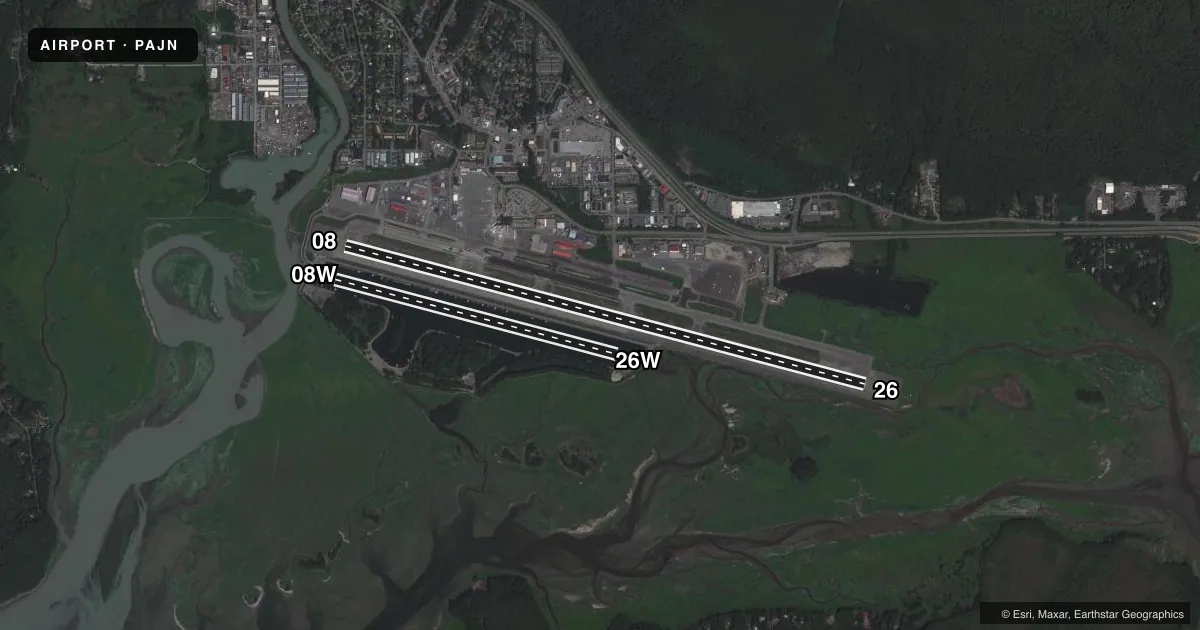
Runways & pattern
Full pagePattern entry · RWY 08
RIGHT TRAFFIC| Runway | Heading (°M) | Length | Surface | Traffic |
|---|---|---|---|---|
| 08/26 | 85° / 265° | 8,857 ft | ASPH | 08 R |
| 08W/26W | 85° / 265° | 4,800 ft | WATER | Standard L |
Runway end performance
| End | TORA | TODA | ASDA | LDA | VGSI | Approach lights | Obstruction |
|---|---|---|---|---|---|---|---|
| 08 | 8,857' | 8,857' | 8,457' | 8,457' | VASI 2-box left(3.5°) | MALSF | 573', tower, 7600' from thr, 900' R of cntrln, slope 12 |
| 26 | 8,857' | 8,857' | 8,457' | 8,457' | PAPI 4-box left(3.5°) | MALS | — |
Declared distances in feet. TORA = takeoff run available, TODA = takeoff distance, ASDA = accelerate-stop, LDA = landing distance.
Airport sketch
Runways drawn to scale from FAA survey coordinates, rendered over satellite imagery. Not for navigation.
Approaches & charts
ILS · 1
Services on the field
Fuel grades, oxygen, maintenance, ramp storage and lighting — as declared to the FAA by the airport operator.
Fuel & services
- Fuel
- 100LLA1+
- Airframe repair
- Major
- Power plant repair
- Major
- Other services
- AFRT,AMB,AVNCS,CARGO,CHTR,INSTR
Ramp & ground
- Transient storage
- Tie-down
- Hangar
- Buoy
- Landing fee
- Yes
- Customs
- Available
- Lighting schedule
- SEE RMK
- Beacon schedule
- SS-SR
- Beacon
- White / Green (civil land)(WG)
- Wind indicator
- Lighted
- Segmented circle
- Yes
Fuel & FBOs
Cheapest 100LL and Jet A on the field and nearby. Always confirm with the FBO before taxi.
Airport notes
Surface conditions, obstructions, local procedures, lighting outages and other notes published with each FAA cycle.
General notes
- NG 24 HR PPR - C907-789-3366. WKDAY 0730-1600 CTC NG OPS 10 MIN BFR LNDG - 124.65.
- WILDLIFE & BIRDS ON & INVOF ARPT.
- BATTLESHIP IS RLLS GROUPING; CNTR LGT 582132.88N 1344012.22W. JDL LOC RLLS GROUPING; CNTR LGT 582132.02N 1343810.39W.
- HVY HEL & ACFT ACT APR 15-OCT 1; FULL LEN GASTINEAU CHNL & WI 5 MI.
- PARAGLIDING ACT 3 MI N; INVOF THUNDER MOUNTAIN & OVR GASTINEAU CHNL NEARS DOWNTOWN APR 15-OCT 1; 6000 FT & BLW.
- TPA 1500 AGL FOR LARGE TURBINE ACFT; 1000 FT AGL FOR FIXED WING ACFT; 500 FT AGL FOR HELICOPTERS.
- JUNEAU FSS - LCL 907-789-7380.
- TSNT PUB DOCK SW CORNER.
- SEE SPL NOTICES & GENOT FOR INFO ON OPS IN JUNEAU AREA.
- LENA POINT, PEDERSON HILL & SISTERS IS WX CAMERAS AVBL ON INTERNET AT HTTPS://WEATHERCAMS.FAA.GOV
- COLD TEMPERATURE AIRPORT. ALTITUDE CORRECTION REQUIRED AT OR BELOW 1C.
- APRON TERM RAMP CLSD TO ROTORCRAFT. CUST RAMP APRON CLSD TO WINGSPAN GTR THAN 79 FT. INTL ROTORCRAFT USE E-1 NG RAMP.
- FUEL SVC - UNICOM OR 907-789-0055/5622.
Lighting notes
- WHEN ATCT CLSD ACTVT MALSF RWY 08; REIL RWY 26; HIRL RWY 08/26 - CTAF. VASI RWY 08; PAPI RWY 26 OPR CONSLY.
Runway surface & condition
- 08/26PCR VALUE: 892/F/A/X/T
- 08/26SAND USED FOR FRICTION MAY NOT MEET FAA SPECS.
Approach & departure obstructions
- 08RLLS LGT: JNUB BATTLESHIP ISLAND, JNUA ENGINEERS CUT, JNU WETLANDS/FLATS.
- 26NSTD; LEN 800 FT.
- 08VASI UNUSBL BYD 06 DEGS LEFT OF CNTRLN. VASI ALIGNED 13 DEG R OF CNTRLN; NOT VIS ON CNTRLN.
- 26RWY 26 PAPI UNUSBL BYD 2 NM DUE TO TRRN.
Other notes
- SINGLE/TWIN PROP ENG; TURBIN & AVIONICS.
- WHEN ATCT CLSD ARPT ADZY SVC - CTAF.
VFR map & nearby airports
VFR sectional. Tap any ICAO chip to open that airport.
Key facts · PAJN
Answer card- ICAO
- PAJN
- Name
- JUNEAU INTL
- Location
- JUNEAU, ALASKA
- Elevation
- 25.3 ft MSL
- Traffic pattern altitude
- 1,025.3 ft MSL (1,000 AGL)
- Control tower
- Towered · 1 APR - SEP 30 0600 - 2300, 1 OCT - MAR 31, 0700 - 2000.
- Total runways
- 2
- Longest runway
- 08/26 · 8,857 ft
- Published ILS approaches
- 1
- Published frequencies
- 8
- Magnetic variation
- 20°
- Current flight rules
- MVFR
- Current wind
- 000° at 0 kt
- Favored runway now
- –
Juneau Intl sits in Juneau, Alaska at 25.3 ft MSL. It has two runways. The longest is runway 08/26 at 8,857 ft. The other is runway 08W/26W on water at 4,800 ft. The airport has a control tower. Tower hours are 0600 to 2300 from 1 April through 30 September. Hours are 0700 to 2000 from 1 October through 31 March.
There is one ILS approach. It serves runway 08. Pattern altitude is not published for this field. Use the standard 1,000 ft AGL for light piston traffic unless ATC or the current Chart Supplement says otherwise. The field has a single on-field FBO. Aero Services is on the field. It carries AVGAS 100LL, JET A and JET A PRIST.
Juneau is a coastal airport with heavy helicopter and aircraft activity from April 15 to October 1. That activity runs along the full length of Gastineau Channel and within 5 miles. Published remarks also note paragliding activity north of the field near Thunder Mountain and over Gastineau Channel during the same seasonal window. Runway 26 has terrain-related limitations on the precision approach path indicator. Runway 08 has a nonstandard approach lighting setup. Plan ahead for the local traffic mix and the water environment. Check the current Chart Supplement and stay sharp on the arrival.