METAR & TAF PAGS
Current METAR
Observed 19:56Z
PAGS 271956Z AUTO 21008KT 10SM -RA OVC006 11/10 A2995 RMK AO2 SLP143 P0005 T01060100 $
- Wind
- 210° @ 8 kt
- Visibility
- 10 SM
- Temp / Dew
- 11°C / 10°C
- Altimeter
- 29.95 inHg
- Clouds
- OVC
- Density alt
- -472 ft
- Ceiling
- 600 ft AGL
- Rules
- IFR
Airport info & contacts
Manager on record, flight service, ARTCC, attendance schedule and pattern altitude — published by the FAA and refreshed every 28 days.
Location
- From city
- 0 NM NE
- VFR sectional
- JUNEAU
- ARTCC
- ZAN · ANCHORAGE
- NOTAM facility
- GST (NOTAM-D)
Airport manager
- Name
- JEFF JARVIS
- Phone
- 907-697-2251
- Address
- PO BOX 239, GUSTAVUS AK 99826
Flight service · Hours
- FSS JNU
- JUNEAU907-586-73801-866-297-2236
- Attendance
- 15 MAY-1 SEP · FRI-MON · 0830-1700
- 15 MAY-1 SEP · TUE-THU · 0500-1700
- 1 SEP-15 MAY · 0600-1430
Frequencies
Tap any row to copy the frequency to your clipboard.
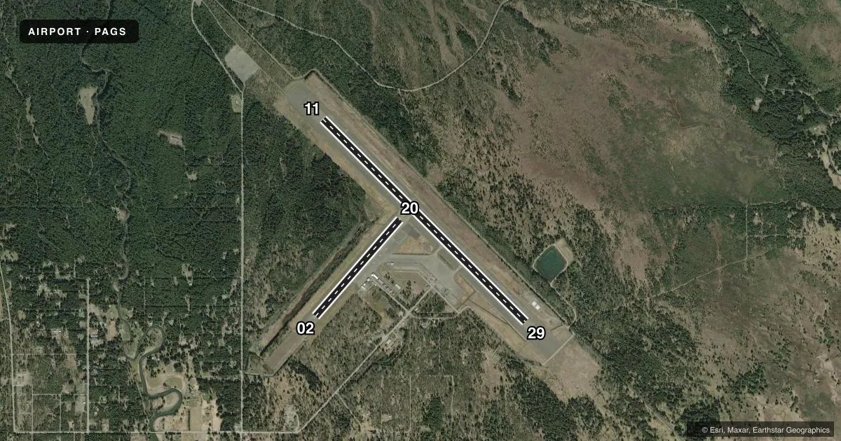
Runways & pattern
Full pagePattern entry · RWY 20
LEFT TRAFFIC| Runway | Heading (°M) | Length | Surface | Traffic |
|---|---|---|---|---|
| 11/29 | 115° / 295° | 6,720 ft | ASPH | Standard L |
| 02/20Favored | 21° / 201° | 3,010 ft | ASPH | Standard L |
Runway end performance
| End | TORA | TODA | ASDA | LDA | VGSI | Approach lights | Obstruction |
|---|---|---|---|---|---|---|---|
| 11 | — | — | — | — | VASI 4-box right(3°) | — | — |
| 29 | — | — | — | — | VASI 4-box left(3°) | — | — |
| 02 | — | — | — | — | — | — | 18', trees, 650' from thr, 0' R of cntrln, slope 25 |
| 20 | — | — | — | — | — | — | 72', trees, 1200' from thr, slope 14 |
Declared distances in feet. TORA = takeoff run available, TODA = takeoff distance, ASDA = accelerate-stop, LDA = landing distance.
Airport sketch
Runways drawn to scale from FAA survey coordinates, rendered over satellite imagery. Not for navigation.
Approaches & charts
Services on the field
Fuel grades, oxygen, maintenance, ramp storage and lighting — as declared to the FAA by the airport operator.
Fuel & services
- Fuel
- A
Ramp & ground
- Transient storage
- Not published
- Landing fee
- No fee published
- Customs
- Not available
- Lighting schedule
- SEE RMK
- Beacon schedule
- SS-SR
- Beacon
- White / Green (civil land)(WG)
- Wind indicator
- Yes
- Segmented circle
- Yes
Fuel & FBOs
Cheapest 100LL and Jet A on the field and nearby. Always confirm with the FBO before taxi.
Airport notes
Surface conditions, obstructions, local procedures, lighting outages and other notes published with each FAA cycle.
General notes
- PAJA ON RWY, TWY OR PRKG APRON NA.
- WILDLIFE ON & INVOF RWY.
- TSNT PRKG E SIDE OF RWY 02/20; ASPH SFC SOFT; ACFT OVR 12500 LBS CTC AMGR 24 HR PRIOR MON-FRI 0600-1430.
- GUSTAVUS & SISTERS ISLAND WX CAMERA AVBL ON INTERNET AT HTTPS://WEATHERCAMS.FAA.GOV
- 24 HR PPR FOR CARGO OPS OVR 100000 LB - AMGR.
- BE ALERT: SEE GENNOT- ENROUTE CTAF FREQS.
- LTD ARPT MAINT SVC AVBL: 1 SEP-14 MAY 0600-1430; 15 MAY-1 SEP FRI-MON 1000-1830, TUE-THU 0600-1830. AFT HR - AMGR.
- ARPT SAND LRGR GRADATION THAN FAA RCMDD/SEE AC150/5200-30.
- COLD TEMPERATURE AIRPORT. ALTITUDE CORRECTION REQUIRED AT OR BELOW -13C.
- TSNT PRKG AVBL GA RAMP ACES VIA TWY F.
Lighting notes
- ACTVT REIL RWY 11 & 29; VASI RWY 11 & 29; MIRL RWY 11/29 - CTAF
Fuel notes
- ACFM AVBL - 907-209-0305.
Runway surface & condition
- 02/20PCR VALUE: 237/F/B/X/T
- 11/29PCR VALUE: 280/F/B/X/T
- 02/20MNTND WINTER MONTHS; RCMD DALGT OPS. 9 FT FENCE 554 FT S. RWY 02/20 NOT AVBL FOR PART 121/380 SKED & NON-SKED OPS WITH PAX CARRYING OPS MORE THAN 30 PAX SEATS.
Other notes
- ARFF SVC AVBL DURG SKED ACR OPS.
- CLSD TO ACR OPS MORE THAN 30 PAX SEATS EXC PPR IN WRITING - RGNL DIR DOT & PUB FAC SE RGN 6860 GLACIER HIGHWAY JUNEAK AK 99801-7999.
VFR map & nearby airports
VFR sectional. Tap any ICAO chip to open that airport.
Key facts · PAGS
Answer card- ICAO
- PAGS
- Name
- GUSTAVUS
- Location
- GUSTAVUS, ALASKA
- Elevation
- 36.3 ft MSL
- Traffic pattern altitude
- 1,036.3 ft MSL (1,000 AGL)
- Control tower
- Non-towered (use CTAF)
- Total runways
- 2
- Longest runway
- 11/29 · 6,720 ft
- Published ILS approaches
- 0
- Published frequencies
- 1
- Magnetic variation
- 20°
- Current flight rules
- IFR
- Current wind
- 210° at 8 kt
- Favored runway now
- RWY 20
Gustavus Airport (PAGS) sits in Gustavus, Alaska at 36.3 ft MSL. It has two asphalt runways. The longest is 11/29 at 6,720 ft. There is no control tower, so use CTAF 122.5 and keep a close scan for traffic and wildlife. No ILS approaches are published here.
The pattern altitude is not published. Use standard 1,000 ft AGL for light piston operations unless local procedures or the current Chart Supplement say otherwise. Magnetic variation is 20°. Runway 11/29 has runway end identifier lights, VASIs and medium intensity runway lights controlled by CTAF. Runway 02/20 is 3,010 ft long. It is maintained in winter. Daylight operations only are recommended on that runway.
Gustavus Dray is on the field. It carries JET A and JET A PRIST. Contract fuel maintenance is available. Call ahead if you need support. The published remarks also note limited airport maintenance service by season. After-hours contact goes to the airport manager. Transient parking is on the east side of runway 02/20. The asphalt there is soft. Aircraft over 12,500 pounds need 24 hours prior contact on weekdays. This is a field where you should plan for wildlife. Plan for runway lighting use and seasonal maintenance limits before you launch.