METAR & TAF N85
N85 does not publish a METAR.
Showing the nearest reporting station: KDYL (DOYLESTOWN) · 16.0 NM away. Conditions at N85 may differ.
METAR · KDYL
Observed 03:54Z
KDYL 120354Z AUTO 22003KT 10SM FEW060 23/20 A2979 RMK AO2 SLP080 T02330200
- Wind
- 220° @ 3 kt
- Visibility
- 10 SM
- Temp / Dew
- 23°C / 20°C
- Altimeter
- 29.79 inHg
- Clouds
- FEW
- Density alt
- 1,716 ft
- Ceiling
- Unlimited
- Rules
- VFR
Airport info & contacts
Manager on record, flight service, ARTCC, attendance schedule and pattern altitude — published by the FAA and refreshed every 28 days.
Location
- From city
- 2 NM W
- VFR sectional
- NEW YORK
- ARTCC
- ZNY · NEW YORK
- NOTAM facility
- MIV (NOTAM-D)
Airport manager
- Name
- TOM HEIMGARTNER
- Phone
- 908-399-1820
- Address
- 15 AIRPORT ROAD, PITTSTOWN NJ 08867
Flight service · Hours
- FSS MIV
- MILLVILLE1-800-WX-BRIEF
- Attendance
- 0800-DUSK
Frequencies
Tap any row to copy the frequency to your clipboard.
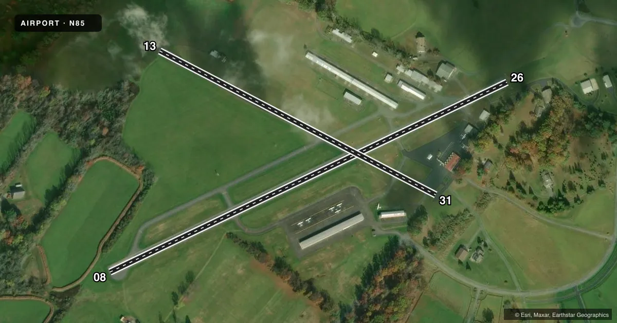
Runways & pattern
Full pagePattern entry · RWY 26
LEFT TRAFFIC| Runway | Heading (°M) | Length | Surface | Traffic |
|---|---|---|---|---|
| 08/26Favored | 54° / 234° | 2,550 ft | ASPH | Standard L |
| 13/31 | 108° / 288° | 1,804 ft | ASPH-TURF | Standard L |
Runway end performance
| End | TORA | TODA | ASDA | LDA | VGSI | Approach lights | Obstruction |
|---|---|---|---|---|---|---|---|
| 08 | — | — | — | — | PAPI 2-box right(3.3°) | — | 50', tree, 481' from thr, 102' R of cntrln, slope 5 |
| 26 | — | — | — | — | PAPI 2-box left(3.75°) | — | 71', tree, 232' from thr, 208' R of cntrln, slope 0 |
| 13 | — | — | — | — | — | — | 16', tree, 433' from thr, 95' R of cntrln, slope 14 |
| 31 | — | — | — | — | — | — | 64', tree, 666' from thr, 142' R of cntrln, slope 7 |
Declared distances in feet. TORA = takeoff run available, TODA = takeoff distance, ASDA = accelerate-stop, LDA = landing distance.
Airport sketch
Runways drawn to scale from FAA survey coordinates, rendered over satellite imagery. Not for navigation.
Approaches & charts
Services on the field
Fuel grades, oxygen, maintenance, ramp storage and lighting — as declared to the FAA by the airport operator.
Fuel & services
- Fuel
- 100LL
- Oxygen (bottled)
- Not available
- Oxygen (bulk)
- Not available
- Airframe repair
- Major
- Power plant repair
- Major
- Other services
- PAJA
Ramp & ground
- Transient storage
- Tie-down
- Hangar
- Landing fee
- No fee published
- Lighting schedule
- SEE RMK
- Beacon schedule
- SEE RMK
- Beacon
- White / Green (civil land)(WG)
- Wind indicator
- Lighted
- Segmented circle
- No
Fuel & FBOs
Cheapest 100LL and Jet A on the field and nearby. Always confirm with the FBO before taxi.
Airport notes
Surface conditions, obstructions, local procedures, lighting outages and other notes published with each FAA cycle.
General notes
- TAXI ON PAVEMENT ONLY.
- HEL TKOF AND LDGS RSTRD TO RWY 08/26 ONLY.
- HEL USE FIXED-WING TFC PAT AND ALTS.
- CTC ARPT MGR 908-730-9223 PRIOR TO CONDUCTING HEL TRNG ACT.
- NO TGL OR STA ALLOWED.
- FOR CD CTC ALLENTOWN APCH AT 800-728-6322.
Lighting notes
- ACTIVATE ROTG BCN - 121.8.
- ACTVT MIRL RY 08/26 - 121.8.
Fuel notes
- 100LL24 HR SELF-SERVICE
Approach & departure obstructions
- 26+33 FT TREE, 58 FT FM RWY END, 108 FT L.
- 31+47 FT TREE, 112 FT FM RWY END, 117 FT L.
- 26PAPI UNUSBL BYD 2 DEGS LEFT OF CNTRLN.
Other notes
- THIS AIRPORT HAS BEEN SURVEYED BY THE NATIONAL GEODETIC SURVEY.
- EXISTED PRIOR TO 1959.
- PAJAPARACHUTE JUMPING MAR-NOV. PARACHUTE DROP ZONE ON NORTH SIDE OF ARPT.
- 13/3125 FT WIDE ASPH STRIP FULL LENGTH DOWN CENTER OF RWY. TURF PORTION OF RWY UNUSABLE.
VFR map & nearby airports
VFR sectional. Tap any ICAO chip to open that airport.
Key facts · N85
Answer card- ICAO
- N85
- Name
- ALEXANDRIA
- Location
- PITTSTOWN, NEW JERSEY
- Elevation
- 480 ft MSL
- Traffic pattern altitude
- 1,480 ft MSL (1,000 AGL)
- Control tower
- Non-towered (use CTAF)
- Total runways
- 2
- Longest runway
- 08/26 · 2,550 ft
- Published ILS approaches
- 0
- Published frequencies
- 5
- Magnetic variation
- 10°
- Current flight rules
- VFR
- Current wind
- 220° at 3 kt
- Favored runway now
- RWY 26
Alexandria Airport (N85) sits in Pittstown, New Jersey at 480 ft MSL. It has two runways. The longest is runway 08/26 at 2,550 ft. Runway 13/31 is 1,804 ft and has an asphalt-turf surface. There is no control tower. For clearance delivery, contact Allentown Approach. The published frequencies include CTAF and UNICOM on 122.975.
No ILS approaches are published here. The published pattern altitude is not listed, so use standard traffic pattern planning unless the current FAA Chart Supplement says otherwise. The field carries 100LL at Alexandria Field. Self-serve fuel is available 24 hours.
A few remarks matter for planning. Taxi on pavement only. Helicopter takeoffs and landings are restricted to runway 08/26 only. There is also a tree near each end of runway 13/31, so pay close attention to runway length and departure performance on that strip. Parachute jumping is conducted from March through November. The drop zone is on the north side of the airport. No touch-and-go or stop-and-go operations are allowed. If you are new to the field, brief the runway lighting procedure too. Medium intensity runway lights and the rotating beacon are activated on 121.8.