METAR & TAF L08
Current METAR
Observed 01:35Z
KL08 100135Z AUTO 18010KT 10SM CLR 37/10 A2965 RMK AO2
- Wind
- 180° @ 10 kt
- Visibility
- 10 SM
- Temp / Dew
- 37°C / 10°C
- Altimeter
- 29.65 inHg
- Clouds
- CLR
- Density alt
- 3,622 ft
- Ceiling
- Unlimited
- Rules
- VFR
Airport info & contacts
Manager on record, flight service, ARTCC, attendance schedule and pattern altitude — published by the FAA and refreshed every 28 days.
Location
- From city
- 3 NM E
- VFR sectional
- LOS ANGELES
- ARTCC
- ZLA · LOS ANGELES
- NOTAM facility
- SAN (NOTAM-D)
Airport manager
- Name
- MEADOW CHASE
- Phone
- 760-788-3366
- Address
- 1820 PALM CANYON DR, BORREGO SPRINGS CA 92004-1235
Flight service · Hours
- FSS SAN
- SAN DIEGO1-800-WX-BRIEF
- Attendance
- 0800-1600
Frequencies
Tap any row to copy the frequency to your clipboard.
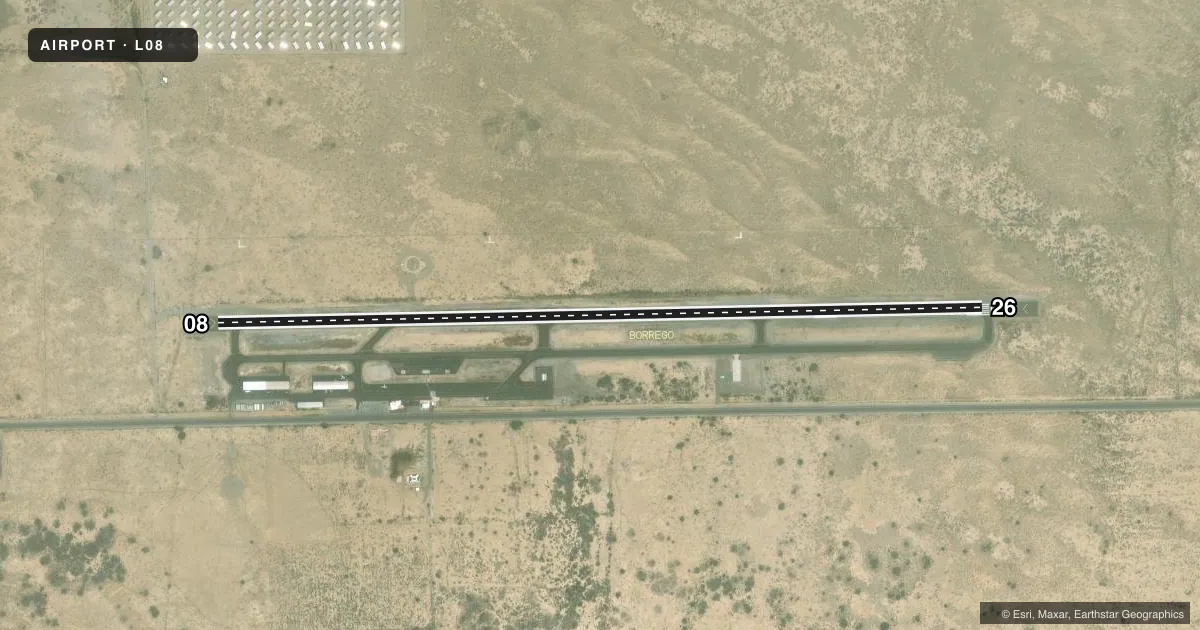
Runways & pattern
Full pagePattern entry · RWY 26
LEFT TRAFFICRunway end performance
| End | TORA | TODA | ASDA | LDA | VGSI | Approach lights | Obstruction |
|---|---|---|---|---|---|---|---|
| 08 | — | — | — | — | PAPI 2-box left(3°) | — | — |
| 26 | — | — | — | — | PAPI 2-box left(3°) | — | — |
Declared distances in feet. TORA = takeoff run available, TODA = takeoff distance, ASDA = accelerate-stop, LDA = landing distance.
Airport sketch
Runways drawn to scale from FAA survey coordinates, rendered over satellite imagery. Not for navigation.
Approaches & charts
Services on the field
Fuel grades, oxygen, maintenance, ramp storage and lighting — as declared to the FAA by the airport operator.
Fuel & services
- Fuel
- 100LL
- Oxygen (bottled)
- Not available
- Oxygen (bulk)
- Not available
- Airframe repair
- Not available
- Power plant repair
- Not available
- Other services
- AMB,INSTR,PAJA
Ramp & ground
- Transient storage
- Tie-down
- Landing fee
- No fee published
- Customs
- Not available
- Lighting schedule
- SEE RMK
- Beacon schedule
- SS-SR
- Beacon
- White / Green (civil land)(WG)
- Wind indicator
- Lighted
- Segmented circle
- Yes
Fuel & FBOs
Cheapest 100LL and Jet A on the field and nearby. Always confirm with the FBO before taxi.
Airport notes
Surface conditions, obstructions, local procedures, lighting outages and other notes published with each FAA cycle.
General notes
- 140 FT TWR 1600 FT N OF RWY 08.
- DURING HOT WX HVY ACFT PRKG RSTRD TO CONCRETE PADS ON OUTER TSNT RAMP.
- AEROBATIC BOX N SIDE OF ARPT DURING DALGT HRS FROM SFC TO 5000 FT MSL, CK NOTAMS FOR ACT.
- NOISE SENSITIVE AREA W-NW. DO NOT OVERFLY ELEMENTARY SCHOOL 1 NM W OF ARPT.
- BE AWARE OF FRQ CHGS IN WIND DIR, STRONG UP/DN DRAFTS AND TURB POSS DURG HIGH WIND CONDS.
- ALL ACFT TFC PATS TO S.
- COYOTES AND MIGRATORY BIRDS OCNLLY ON OR IN VACINITY OF ARPT.
- PPR FOR ALL MIL ACFT, CTC AMGR.
- ACFT MUST SELF-ANNOUNCE ON CTAF PRIOR TO LDG OR TKOF.
- TSNT TIE-DOWN RAMP RSTRD TO ACFT WITH WINGSPAN 40 FT OR LESS. ACFT WITH GTR THAN 40 FT WINGSPAN PARK ON PORTION OF TSNT RAMP E OF A6.
- MIL ROTORCRAFT OPS RSTRD TO REMAIN ON OR OVER PAVEMENT AREA, TGL RSTRD TO RWY.
- HOVERS, SKID LNDGS, AUTO-ROTATIONS PROHIBITED.
- FOR CD CTC LOS ANGELES ARTCC AT 661-575-2079.
- PARACHUTE JUMPING.
Lighting notes
- ACTVT MIRL RWY 08/26; TWY LGTS - CTAF (5 CLICKS ON).
Fuel notes
- 100LLSELF SVC 24 HR.
Runway surface & condition
- 08/26RWY 08/26 400 FT BLAST PAD BYD EACH END OF RWY AREA.
Approach & departure obstructions
- 08UNUSBL BYD 3.0 NM DUE TO TRRN.
Other notes
- STAFFED 0800-1600
- MANAGERDIR OF CO ARPTS OFC IS AT GILLESPIE FIELD ARPT. BORREGO VALLEY ARPT ON-SITE MGR IS MEADOW CHASE PH 760-767-7415, FAX 760-767-5727.
- MANAGEREMERG: 760-884-0252
VFR map & nearby airports
VFR sectional. Tap any ICAO chip to open that airport.
Key facts · L08
Answer card- ICAO
- L08
- Name
- BORREGO VALLEY
- Location
- BORREGO SPRINGS, CALIFORNIA
- Elevation
- 522.2 ft MSL
- Traffic pattern altitude
- 1,522.2 ft MSL (1,000 AGL)
- Control tower
- Non-towered (use CTAF)
- Total runways
- 1
- Longest runway
- 08/26 · 5,011 ft
- Published ILS approaches
- 0
- Published frequencies
- 2
- Magnetic variation
- 13°
- Current flight rules
- VFR
- Current wind
- 180° at 10 kt
- Favored runway now
- RWY 26
Borrego Valley Airport sits in Borrego Springs, California. Field elevation is 522.2 ft MSL. The airport has one runway. Runway 08/26 is 5,011 ft long with asphalt pavement. It is not a towered field. CTAF and UNICOM are both 122.8. The airport is staffed from 0800 to 1600. No ILS approaches are published here. Plan with the current chart data before you go.
Pattern altitude is not published. Use the standard 1,000 ft AGL pattern unless local procedures or the current Chart Supplement say otherwise. The on-field FBO is Borrego Valley Airport. It carries 100LL. Self-service 100LL is available 24 hours. Medium intensity runway lights are available on 08/26. Taxiway lights are activated on CTAF by keying the microphone five times.
This is a desert airport, so expect wind shifts. The published remarks call out strong updrafts, downdrafts and turbulence in high wind conditions. Coyotes and migratory birds can also be on or near the field. Noise-sensitive areas lie west to northwest. Do not overfly the elementary school about 1 NM west of the airport. The transient ramp has wingspan limits, so check parking needs before arrival if you are in a larger aircraft. For clearance delivery, contact Los Angeles ARTCC.