METAR & TAF KWMC
Current METAR
Observed 07:56Z
KWMC 120756Z AUTO 00000KT 10SM CLR 09/M07 A3006 RMK AO2 SLP148 T00941072 402830083
- Wind
- 000° @ 0 kt
- Visibility
- 10 SM
- Temp / Dew
- 9°C / -7°C
- Altimeter
- 30.06 inHg
- Clouds
- CLR
- Density alt
- 4,448 ft
- Ceiling
- Unlimited
- Rules
- VFR
Airport info & contacts
Manager on record, flight service, ARTCC, attendance schedule and pattern altitude — published by the FAA and refreshed every 28 days.
Location
- From city
- 5 NM SW
- VFR sectional
- KLAMATH FALLS
- Pattern altitude
- 800 ft AGL · 5,108 ft MSL
- ARTCC
- ZLC · SALT LAKE CITY
- NOTAM facility
- WMC (NOTAM-D)
Airport manager
- Name
- ALICIA HEISER
- Phone
- 775-623-6333
- Address
- 90 WEST FOURTH STREET, WINNEMUCCA NV 89445
Flight service · Hours
- FSS RNO
- RENO1-800-WX-BRIEF
- Attendance
- JUN-OCT · 0700-1800
- NOV-MAY · MON -FRI · 0800-1700
Frequencies
Tap any row to copy the frequency to your clipboard.
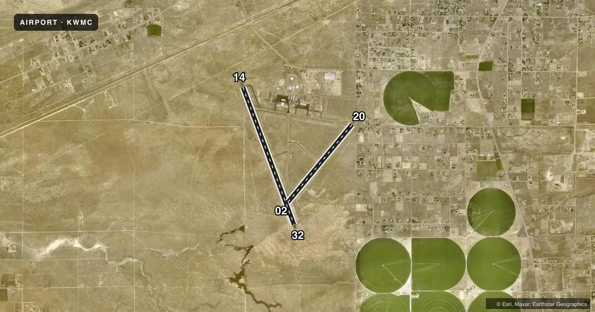
Runways & pattern
Full pagePattern entry · RWY 14
LEFT TRAFFIC| Runway | Heading (°M) | Length | Surface | Traffic |
|---|---|---|---|---|
| 14/32 | 144° / 324° | 7,000 ft | ASPH | Standard L |
| 02/20 | 24° / 204° | 4,800 ft | ASPH | Standard L |
Runway end performance
| End | TORA | TODA | ASDA | LDA | VGSI | Approach lights | Obstruction |
|---|---|---|---|---|---|---|---|
| 14 | — | — | — | — | PAPI 2-box left(3°) | — | 30', pline, 1000' from thr, 0' R of cntrln, slope 26 |
| 32 | — | — | — | — | PAPI 2-box left(3°) | — | — |
| 20 | — | — | — | — | PAPI 2-box left(3°) | — | 12', road, 500' from thr, 0' R of cntrln, slope 25 |
Declared distances in feet. TORA = takeoff run available, TODA = takeoff distance, ASDA = accelerate-stop, LDA = landing distance.
Airport sketch
Runways drawn to scale from FAA survey coordinates, rendered over satellite imagery. Not for navigation.
Approaches & charts
Services on the field
Fuel grades, oxygen, maintenance, ramp storage and lighting — as declared to the FAA by the airport operator.
Fuel & services
- Fuel
- 100LLA
- Oxygen (bottled)
- HIGH/LOW
- Oxygen (bulk)
- Not available
- Airframe repair
- Minor
- Power plant repair
- Minor
- Other services
- AMB,INSTR,RNTL
Ramp & ground
- Transient storage
- Tie-down
- Hangar
- Landing fee
- No fee published
- Customs
- Not available
- Lighting schedule
- SEE RMK
- Beacon schedule
- SS-SR
- Beacon
- White / Green (civil land)(WG)
- Wind indicator
- Lighted
- Segmented circle
- Yes
Fuel & FBOs
Cheapest 100LL and Jet A on the field and nearby. Always confirm with the FBO before taxi.
Airport notes
Surface conditions, obstructions, local procedures, lighting outages and other notes published with each FAA cycle.
General notes
- FULL STRENGTH PAVEMENT AREAS INCLUDE N 1000 FT OF PARALLEL TWY (RWY 14/32 TO TWY A); W 1000 FT OF TWY A; 600 FT OF N/S TWR (FM TWY A).
- MOUNTAINS IN SW QUADRANT.
- CALL FBO FOR CURRENT RWY CONDS IN WINTER MONTHS.
- FOR CD IF UNA TO CTC ON FSS FREQ, CTC SALT LAKE ARTCC AT 801-320-2568.
Lighting notes
- ACTVT REIL RWYS 14 & 32, 20; MIRL RWY 14/32 - CTAF. PRESET LO INTST; INCR/DECR INTST - CTAF.
Runway surface & condition
- 02/20PCR VALUE: 80/F/C/X/T
- 14/32PCR VALUE: 340/F/C/X/T
- H1UNMRKD 25 FT X 25 FT CONCRETE TLOF ADJACENT TO APRON PRKG AND TWY ALPHA.
- H2H2 ADJACENT TO APRON PRKG AND TAXIWAY ALPHA
Other notes
- CONSTRUCTED PRIOR TO 5/15/59.
- 3AFT HRS OR EMERG CALL (775) 304-5885.
- MANAGERFBO - WINNEMUCCA AIR SERVICE 775-623-5091.
- H1H1 PAD PERIMETER EDGING IS DAMAGED
- H2H2 PERIMETER EDGING IS DAMAGED.
VFR map & nearby airports
VFR sectional. Tap any ICAO chip to open that airport.
Key facts · KWMC
Answer card- ICAO
- KWMC
- Name
- WINNEMUCCA MUNI
- Location
- WINNEMUCCA, NEVADA
- Elevation
- 4,307.6 ft MSL
- Traffic pattern altitude
- 5,107.6 ft MSL (800 AGL)
- Control tower
- Non-towered (use CTAF)
- Total runways
- 2
- Longest runway
- 14/32 · 7,000 ft
- Published ILS approaches
- 0
- Published frequencies
- 2
- Magnetic variation
- 16°
- Current flight rules
- VFR
- Current wind
- 000° at 0 kt
- Favored runway now
- –
Winnemucca Muni (KWMC) sits in Winnemucca, Nevada. Field elevation is 4,307.6 ft MSL. The airport has two asphalt runways. The longest is runway 14/32 at 7,000 ft. Runway 02/20 is 4,800 ft. There is no control tower. CTAF and UNICOM are both 122.8.
No ILS approaches are published here. Pattern altitude is 800 ft AGL, which is 5,107.6 ft MSL. That matters at this elevation. Expect performance to be a real factor, especially on warm days. The published remarks also note mountains in the southwest quadrant. Give yourself a careful look at terrain and climb performance before departure.
Winnemucca Air Service is on the field. It carries 100LL, Jet A and Jet A Prist. The FBO can be reached at (775) 623-5091. Published remarks also note runway lighting details. Runways 14 and 32 have runway end identifier lights. Runway 14/32 has medium intensity runway lights. The CTAF can control preset low intensity. It can increase or decrease intensity. For winter runway condition checks, call the FBO directly. If you need clearance delivery and cannot reach Flight Service, contact Salt Lake ARTCC at 801-320-2568.