METAR & TAF KVMR
Current METAR
Observed 13:35Z
KVMR 121335Z AUTO 31007KT 10SM CLR 20/11 A2998 RMK AO2
- Wind
- 310° @ 7 kt
- Visibility
- 10 SM
- Temp / Dew
- 20°C / 11°C
- Altimeter
- 29.98 inHg
- Clouds
- CLR
- Density alt
- 1,948 ft
- Ceiling
- Unlimited
- Rules
- VFR
Airport info & contacts
Manager on record, flight service, ARTCC, attendance schedule and pattern altitude — published by the FAA and refreshed every 28 days.
Location
- From city
- 1 NM S
- VFR sectional
- OMAHA
- ARTCC
- ZMP · MINNEAPOLIS
- NOTAM facility
- HON (NOTAM-D)
Airport manager
- Name
- DENNY MARTENS
- Phone
- 605-677-8159
- Address
- 25 CENTER ST., VERMILLION SD 57069
Flight service · Hours
- FSS HON
- HURON1-800-WX-BRIEF
- Attendance
- MON-FRI · 0800-1700
Frequencies
Tap any row to copy the frequency to your clipboard.
Runways & pattern
Full pagePattern entry · RWY 30
LEFT TRAFFICRunway end performance
| End | TORA | TODA | ASDA | LDA | VGSI | Approach lights | Obstruction |
|---|---|---|---|---|---|---|---|
| 12 | — | — | — | — | PAPI 2-box left(3°) | — | — |
| 30 | — | — | — | — | PAPI 2-box left(3°) | — | — |
Declared distances in feet. TORA = takeoff run available, TODA = takeoff distance, ASDA = accelerate-stop, LDA = landing distance.
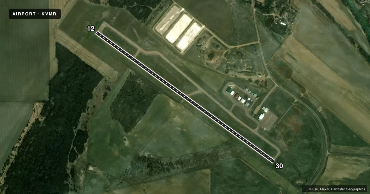
Airport sketch
Runways drawn to scale from FAA survey coordinates, rendered over satellite imagery. Not for navigation.
Approaches & charts
Services on the field
Fuel grades, oxygen, maintenance, ramp storage and lighting — as declared to the FAA by the airport operator.
Fuel & services
- Fuel
- 100LLA
- Oxygen (bottled)
- Not available
- Oxygen (bulk)
- Not available
- Airframe repair
- Major
- Power plant repair
- Major
- Other services
- AGRI,INSTR,RNTL
Ramp & ground
- Transient storage
- Tie-down
- Hangar
- Landing fee
- No fee published
- Customs
- Not available
- Lighting schedule
- SEE RMK
- Beacon schedule
- SS-SR
- Beacon
- White / Green (civil land)(WG)
- Wind indicator
- Lighted
- Segmented circle
- No
Fuel & FBOs
Cheapest 100LL and Jet A on the field and nearby. Always confirm with the FBO before taxi.
Airport notes
Surface conditions, obstructions, local procedures, lighting outages and other notes published with each FAA cycle.
General notes
- WATERFOWL AND BIRDS ON AND INVOF ARPT.
- FOR CD CTC SIOUX CITY APCH AT 712-293-2482. WHEN SIOUX CITY APCH CLSD, FOR CD CTC MINNEAPOLIS ARTCC AT 651-463-5588.
Lighting notes
- ACTVT PAPI RWY 12 & 30; MIRL RWY 12/30 - CTAF.
Fuel notes
- AFUEL AVBL 24 HRS WITH CREDIT CARD.
Other notes
- AUTOMATED UNICOM.
VFR map & nearby airports
VFR sectional. Tap any ICAO chip to open that airport.
Key facts · KVMR
Answer card- ICAO
- KVMR
- Name
- HAROLD DAVIDSON FLD
- Location
- VERMILLION, SOUTH DAKOTA
- Elevation
- 1,146.7 ft MSL
- Traffic pattern altitude
- 2,146.7 ft MSL (1,000 AGL)
- Control tower
- Non-towered (use CTAF)
- Total runways
- 1
- Longest runway
- 12/30 · 4,105 ft
- Published ILS approaches
- 0
- Published frequencies
- 4
- Magnetic variation
- 3°
- Current flight rules
- VFR
- Current wind
- 310° at 7 kt
- Favored runway now
- RWY 30
Harold Davidson Fld sits in Vermillion, South Dakota. Field elevation is 1,146.7 ft MSL. The airport has one runway, 12/30, at 4,105 ft of concrete. There is no control tower. Pattern altitude is not published, so use the standard 1,000 ft AGL for light piston traffic unless the current Chart Supplement says otherwise. No ILS approaches are published here.
For radio work, CTAF and UNICOM are both 122.8. Sioux City Approach handles clearance delivery at 124.6 and 307.0. When Sioux City Approach is closed, clearance delivery goes to Minneapolis ARTCC. The field has one on-field FBO, Harold Davidson Field. It carries 100LL and Jet A Prist. Fuel is available 24 hours with credit card. Automated UNICOM is also available.
Runway lighting is medium intensity on 12 and 30. The PAPI is activated for both runway ends. That helps at night or in marginal light. One item to keep in mind is bird activity. Waterfowl and birds are reported on and near the airport, so keep a sharp scan on arrival and departure. If you need current noise or local operating limits, check the current FAA Chart Supplement before you go.