METAR & TAF KVJI
Current METAR
Observed 23:15Z
KVJI 112315Z AUTO 28005KT 10SM CLR 28/17 A3001 RMK AO2
- Wind
- 280° @ 5 kt
- Visibility
- 10 SM
- Temp / Dew
- 28°C / 17°C
- Altimeter
- 30.01 inHg
- Clouds
- CLR
- Density alt
- 4,037 ft
- Ceiling
- Unlimited
- Rules
- VFR
Airport info & contacts
Manager on record, flight service, ARTCC, attendance schedule and pattern altitude — published by the FAA and refreshed every 28 days.
Location
- From city
- 2 NM W
- VFR sectional
- CINCINNATI
- Pattern altitude
- 990 ft AGL · 3,078 ft MSL
- ARTCC
- ZTL · ATLANTA
- NOTAM facility
- VJI (NOTAM-D)
Airport manager
- Name
- MICKEY HINES
- Phone
- 276-628-2909
- Address
- PO BOX 631, ABINGDON VA 24212
Flight service · Hours
- FSS DCA
- LEESBURG1-800-WX-BRIEF
- Attendance
- 1200-0000Z
Frequencies
Tap any row to copy the frequency to your clipboard.
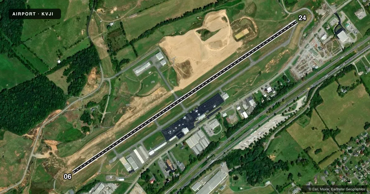
Runways & pattern
Full pagePattern entry · RWY 24
LEFT TRAFFICRunway end performance
| End | TORA | TODA | ASDA | LDA | VGSI | Approach lights | Obstruction |
|---|---|---|---|---|---|---|---|
| 06 | — | — | — | — | — | — | 151', tree, 4032' from thr, 255' R of cntrln, slope 25 |
| 24 | — | — | — | — | PAPI 2-box left(3.25°) | ODALS | 81', tree, 2166' from thr, 429' R of cntrln, slope 24 |
Declared distances in feet. TORA = takeoff run available, TODA = takeoff distance, ASDA = accelerate-stop, LDA = landing distance.
Airport sketch
Runways drawn to scale from FAA survey coordinates, rendered over satellite imagery. Not for navigation.
Approaches & charts
ILS · 1
Services on the field
Fuel grades, oxygen, maintenance, ramp storage and lighting — as declared to the FAA by the airport operator.
Fuel & services
- Fuel
- 100LLA
- Oxygen (bottled)
- Not available
- Oxygen (bulk)
- Not available
- Airframe repair
- Major
- Power plant repair
- Major
- Other services
- CHTR,INSTR,RNTL
Ramp & ground
- Transient storage
- Tie-down
- Hangar
- Landing fee
- No fee published
- Customs
- Not available
- Lighting schedule
- SEE RMK
- Beacon schedule
- SS-SR
- Beacon
- White / Green (civil land)(WG)
- Wind indicator
- Lighted
- Segmented circle
- Yes
Fuel & FBOs
Cheapest 100LL and Jet A on the field and nearby. Always confirm with the FBO before taxi.
Airport notes
Surface conditions, obstructions, local procedures, lighting outages and other notes published with each FAA cycle.
General notes
- WILDLIFE INVOF ARPT.
- WHEN TRI CITIES APCH CLSD, FOR CD CTC ATLANTA ARTCC AT 770-210-7692.
Lighting notes
- ACTVT ODALS RWY 24; REIL RWY 06 & 24; PAPI RWY 24; MIRL RWY 06/24 - CTAF.
- ULTRALIGHTS ON & INVOF ARPT.
Fuel notes
- 100LLFOR FUEL AFT HRS, ARNG BFR 0000Z HRS AT 276-628-6030 OR 276-274-4040. THERE IS A FEE CTC FBO.
- APRIST, ANTI-ICING FUEL ADDITIVE AVBL.
Other notes
- TRANSIENT HANGAR WHEN AVAILABLE.
- 1UNATNDD NEW YEAR'S DAY, JULY 4TH, THANKSGIVING DAY, AND CHRISTMAS DAY.
- CHTRBASED AT TRI, PICKS UP AT VJI.
VFR map & nearby airports
VFR sectional. Tap any ICAO chip to open that airport.
Key facts · KVJI
Answer card- ICAO
- KVJI
- Name
- VIRGINIA HIGHLANDS
- Location
- ABINGDON, VIRGINIA
- Elevation
- 2,087.5 ft MSL
- Traffic pattern altitude
- 3,077.5 ft MSL (990 AGL)
- Control tower
- Non-towered (use CTAF)
- Total runways
- 1
- Longest runway
- 06/24 · 5,500 ft
- Published ILS approaches
- 1
- Published frequencies
- 4
- Magnetic variation
- 5°
- Current flight rules
- VFR
- Current wind
- 280° at 5 kt
- Favored runway now
- RWY 24
Virginia Highlands Airport sits in Abingdon, Virginia. The field elevation is 2,087.5 ft MSL. It has one runway. Runway 06/24 is 5,500 ft long with asphalt pavement. The longest runway is 5,500 ft. There is no control tower. Plan on CTAF work and standard non-towered procedures.
The airport has one ILS approach. It serves runway 24. Pattern altitude is 990 ft AGL, which is 3,077.5 ft MSL. The on-field FBO is Virginia Highlands Airport. It carries 100LL, Jet A and Jet A Prist. Prist and anti-icing additive are available. For fuel after hours, arrange ahead of time by phone with the FBO. The published remarks also note that the airport is unattended on New Year's Day, July 4th, Thanksgiving Day and Christmas Day.
Lighting is pilot-controlled on CTAF. Runway 24 has approach lighting, runway end identifier lights, a PAPI and medium intensity runway lights. Runway 06 also has runway end identifier lights and medium intensity runway lights. Expect wildlife in the area. Ultralight traffic is also reported on and near the airport. If Tri Cities Approach is closed, clearance delivery goes through Atlanta ARTCC. For a first visit, pay attention to the high field elevation. Also plan for the non-towered environment and the lighting setup on runway 24.