METAR & TAF KRTS
Current METAR
Observed 02:35Z
KRTS 120235Z AUTO 06010KT 10SM CLR 26/M07 A3006 RMK AO2
- Wind
- 060° @ 10 kt
- Visibility
- 10 SM
- Temp / Dew
- 26°C / -7°C
- Altimeter
- 30.06 inHg
- Clouds
- CLR
- Density alt
- 7,409 ft
- Ceiling
- Unlimited
- Rules
- VFR
Airport info & contacts
Manager on record, flight service, ARTCC, attendance schedule and pattern altitude — published by the FAA and refreshed every 28 days.
Location
- From city
- 10 NM NW
- VFR sectional
- SAN FRANCISCO
- Pattern altitude
- 800 ft AGL · 5,850 ft MSL
- ARTCC
- ZOA · OAKLAND
- NOTAM facility
- RTS (NOTAM-D)
Airport manager
- Name
- SCOTT GORDON
- Phone
- 775-328-6573
- Address
- 4895 TEXAS AVE, RENO NV 89506
Flight service · Hours
- FSS RNO
- RENO1-800-WX-BRIEF
- Attendance
- MONDAY - FRIDAY · 0700-1630
Frequencies
Tap any row to copy the frequency to your clipboard.
Runways & pattern
Full pagePattern entry · RWY 08
LEFT TRAFFIC| Runway | Heading (°M) | Length | Surface | Traffic |
|---|---|---|---|---|
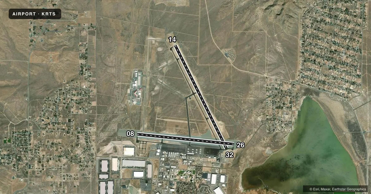
| 14/32 | 137° / 317° | 9,000 ft | ASPH | 32 R |
| 08/26Favored | 80° / 260° | 7,608 ft | ASPH | 26 R |
Runway end performance
| End | TORA | TODA | ASDA | LDA | VGSI | Approach lights | Obstruction |
|---|---|---|---|---|---|---|---|
| 14 | — | — | — | — | PAPI 4-box left(3°) | — | — |
| 32 | — | — | — | 7,800' | PAPI 4-box left(3°) | MALSR | — |
| 08 | 6,956' | 6,956' | — | 6,956' | PAPI 4-box left(4°) | — | — |
| 26 | — | — | — | 7,294' | PAPI 4-box left(3°) | — | — |
Declared distances in feet. TORA = takeoff run available, TODA = takeoff distance, ASDA = accelerate-stop, LDA = landing distance.
Airport sketch
Runways drawn to scale from FAA survey coordinates, rendered over satellite imagery. Not for navigation.
Approaches & charts
ILS · 1
Services on the field
Fuel grades, oxygen, maintenance, ramp storage and lighting — as declared to the FAA by the airport operator.
Fuel & services
- Fuel
- 100LLA
- Oxygen (bottled)
- High pressure
- Oxygen (bulk)
- High pressure
- Airframe repair
- Major
- Power plant repair
- Major
- Other services
- AFRT,AMB,AVNCS,INSTR,PAJA,RNTL
Ramp & ground
- Transient storage
- Tie-down
- Hangar
- Landing fee
- No fee published
- Customs
- Not available
- Lighting schedule
- SEE RMK
- Beacon schedule
- SS-SR
- Beacon
- White / Green (civil land)(WG)
- Wind indicator
- Lighted
- Segmented circle
- Yes
Fuel & FBOs
Cheapest 100LL and Jet A on the field and nearby. Always confirm with the FBO before taxi.
Airport notes
Surface conditions, obstructions, local procedures, lighting outages and other notes published with each FAA cycle.
General notes
- RNG HEL OPS INVOF ARPT; BALLOON OPS NW QUAD; TANKER & FIRE OPS INVOF ARPT DURG FIRE SEASON.
- COLD TEMPERATURE AIRPORT. ALTITUDE CORRECTION REQUIRED AT OR BELOW -15C.
- FOR CD CTC NORCAL APCH AT 916-361-0596.
- FUEL AVBL H24 - 775-530-7164 OR 122.775.
Lighting notes
- ACTVT MALSR RWY 32; REIL RWY 14; HIRL RWY 14/32 - CTAF. PAPI RWY 32 ON CONSLY.
Approach & departure obstructions
- 08PAPI UNUSBL BYD 5 DEGS RIGHT OF CNTRLN.
- 14PAPI OTS INDEFLY.
Other notes
- TPA-6246(1200) HEAVY/HIGH PERFORMANCE ACFT.
VFR map & nearby airports
VFR sectional. Tap any ICAO chip to open that airport.
Key facts · KRTS
Answer card- ICAO
- KRTS
- Name
- RENO/STEAD
- Location
- RENO, NEVADA
- Elevation
- 5,050.1 ft MSL
- Traffic pattern altitude
- 5,850.1 ft MSL (800 AGL)
- Control tower
- Non-towered (use CTAF)
- Total runways
- 2
- Longest runway
- 14/32 · 9,000 ft
- Published ILS approaches
- 1
- Published frequencies
- 4
- Magnetic variation
- 16°
- Current flight rules
- VFR
- Current wind
- 060° at 10 kt
- Favored runway now
- RWY 08
Reno/Stead (KRTS) is in Reno, Nevada. The field elevation is 5,050.1 ft MSL. It has 2 asphalt runways. The longest is runway 14/32 at 9,000 ft. There is no control tower. NorCal Approach handles clearance delivery. Towered services are not part of the field.
The airport has 1 ILS approach. It serves runway 32. Pattern altitude is 5,850.1 ft MSL. That is 800 ft AGL. Aviation Classics is on the field. It carries 100LL, Jet A and Jet A Prist. Fuel is published as available 24 hours a day. The airport also has cold temperature correction requirements at or below minus 15 degrees Celsius. That matters here because the field already sits at high elevation.
There are a few operational items to plan around. Ranger helicopter work happens in the area. Balloon operations occur in the northwest quadrant. Tanker and fire activity can also show up during fire season. Runway 32 has approach lighting, high intensity runway lights and a PAPI that is on continuously. Runway 14 has REILs. The PAPI on runway 14 is out of service indefinitely. The PAPI on runway 08 is unusable beyond 5 degrees right of centerline. For a first visit, review the current Chart Supplement. Be ready for high-density performance planning at this elevation.