METAR & TAF KRNC
Current METAR
Observed 01:55Z
KRNC 120155Z AUTO 00000KT 10SM CLR 26/21 A2994 RMK A01
- Wind
- 000° @ 0 kt
- Visibility
- 10 SM
- Temp / Dew
- 26°C / 21°C
- Altimeter
- 29.94 inHg
- Clouds
- CLR
- Density alt
- 2,575 ft
- Ceiling
- Unlimited
- Rules
- VFR
Airport info & contacts
Manager on record, flight service, ARTCC, attendance schedule and pattern altitude — published by the FAA and refreshed every 28 days.
Location
- From city
- 3 NM W
- VFR sectional
- ATLANTA
- ARTCC
- ZME · MEMPHIS
- NOTAM facility
- BNA (NOTAM-D)
Airport manager
- Name
- JIM DYER
- Phone
- 931-668-7050
- Address
- 48 WEST AIRPORT ROAD, MC MINNVILLE TN 37110
Flight service · Hours
- FSS BNA
- NASHVILLE1-800-WX-BRIEF
- Attendance
- 0800-1700
Frequencies
Tap any row to copy the frequency to your clipboard.
Runways & pattern
Full pagePattern entry · RWY 05
LEFT TRAFFICRunway end performance
| End | TORA | TODA | ASDA | LDA | VGSI | Approach lights | Obstruction |
|---|---|---|---|---|---|---|---|
| 05 | — | — | — | — | PAPI 4-box left(4°) | — | 107', trees, 1797' from thr, 349' R of cntrln, slope 14 |
| 23 | — | — | — | — | PAPI 4-box left(3°) | — | — |
Declared distances in feet. TORA = takeoff run available, TODA = takeoff distance, ASDA = accelerate-stop, LDA = landing distance.
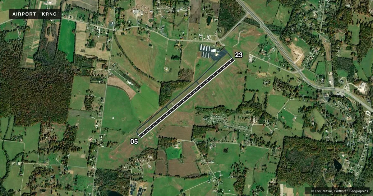
Airport sketch
Runways drawn to scale from FAA survey coordinates, rendered over satellite imagery. Not for navigation.
Approaches & charts
Services on the field
Fuel grades, oxygen, maintenance, ramp storage and lighting — as declared to the FAA by the airport operator.
Fuel & services
- Fuel
- 100LLA+
- Airframe repair
- Major
- Power plant repair
- Major
Ramp & ground
- Transient storage
- Tie-down
- Hangar
- Landing fee
- No fee published
- Customs
- Not available
- Lighting schedule
- SEE RMK
- Beacon schedule
- SS-SR
- Beacon
- White / Green (civil land)(WG)
- Wind indicator
- Lighted
- Segmented circle
- Yes
Fuel & FBOs
Cheapest 100LL and Jet A on the field and nearby. Always confirm with the FBO before taxi.
Airport notes
Surface conditions, obstructions, local procedures, lighting outages and other notes published with each FAA cycle.
General notes
- FOR CD CTC MEMPHIS ARTCC AT 901-368-8453/8449.
Lighting notes
- ACTVT REIL RWY 05 & 23; PAPI RWY 05 & 23; MIRL RWY 05/23 - CTAF. MIRL RWY 05/23 PRESET LOW INTST; INCR INTST - CTAF.
Approach & departure obstructions
- 05PAPI UNUSBL BYD 7 DEGS LEFT OF CNTRLN.
- 23OBSTN CLNC SLOPE 40:1 AT DTHR.
Other notes
- 3FOR SVC AFT HRS CALL 931-271-0856; CLSD THANKSGIVING, CHRISTMAS, AND NEW YEARS DAY
VFR map & nearby airports
VFR sectional. Tap any ICAO chip to open that airport.
Key facts · KRNC
Answer card- ICAO
- KRNC
- Name
- WARREN COUNTY MEML
- Location
- MC MINNVILLE, TENNESSEE
- Elevation
- 1,031.9 ft MSL
- Traffic pattern altitude
- 2,031.9 ft MSL (1,000 AGL)
- Control tower
- Non-towered (use CTAF)
- Total runways
- 1
- Longest runway
- 05/23 · 5,000 ft
- Published ILS approaches
- 0
- Published frequencies
- 2
- Magnetic variation
- 2°
- Current flight rules
- VFR
- Current wind
- 000° at 0 kt
- Favored runway now
- –
Warren County Memorial Airport sits in McMinnville, Tennessee. Field elevation is 1,031.9 ft MSL. The airport has one runway. Runway 05/23 is 5,000 ft of asphalt. There is no control tower. CTAF and UNICOM are both 123.05.
No ILS approaches are published here. Pattern altitude is not published, so use the standard 1,000 ft AGL for light piston operations unless the current Chart Supplement says otherwise. The field has REIL lighting on both runway ends. PAPI is available on 05 and 23. Medium intensity runway lighting is available on 05/23. It is controlled by CTAF. The lighting is preset to low intensity. You may need to key the mic to bring it up.
Warren County Memorial Airport is the on-field FBO. It carries 100LL and Jet A Prist. For after-hours service, call the number in the Chart Supplement. The airport is closed on Thanksgiving, Christmas and New Year's Day. Pilots should also note the published obstruction note for runway 23. The obstacle clearance slope is 40 to 1 at the displaced threshold. For clearance delivery, Memphis ARTCC is the published contact. This is a non-towered field. Plan your arrival, self-announce clearly and verify current procedures before you go.