METAR & TAF KRHV
Current METAR
Observed 00:57Z
KRHV 120057Z 33011KT 10SM SKC 32/11 A2976
- Wind
- 330° @ 11 kt
- Visibility
- 10 SM
- Temp / Dew
- 32°C / 11°C
- Altimeter
- 29.76 inHg
- Clouds
- SKC
- Density alt
- 2,406 ft
- Ceiling
- Unlimited
- Rules
- VFR
Airport info & contacts
Manager on record, flight service, ARTCC, attendance schedule and pattern altitude — published by the FAA and refreshed every 28 days.
Location
- From city
- 4 NM SE
- VFR sectional
- SAN FRANCISCO
- ARTCC
- ZOA · OAKLAND
- NOTAM facility
- RHV (NOTAM-D)
Airport manager
- Name
- ERIC PETERSON
- Phone
- 408-918-7700
- Address
- 2500 CUNNINGHAM AVE., SAN JOSE CA 95148
Flight service · Hours
- FSS OAK
- OAKLAND1-800-WX-BRIEF
- Attendance
- 0800-1800
Frequencies
Tap any row to copy the frequency to your clipboard.
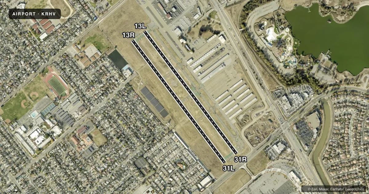
Runways & pattern
Full pagePattern entry · RWY 31R
RIGHT TRAFFIC| Runway | Heading (°M) | Length | Surface | Traffic |
|---|---|---|---|---|
| 13L/31RFavored | 127° / 307° | 3,100 ft | ASPH | 31R R |
| 13R/31L | 127° / 307° | 3,099 ft | ASPH | 13R R |
Runway end performance
| End | TORA | TODA | ASDA | LDA | VGSI | Approach lights | Obstruction |
|---|---|---|---|---|---|---|---|
| 13L | — | — | — | — | PAPI 4-box right(4°) | — | 47', tree, 920' from thr, 205' R of cntrln, slope 15 |
| 31R | — | — | — | — | PAPI 4-box left(4°) | — | 16', road, 200' from thr, 0' R of cntrln, slope 0 |
| 13R | — | — | — | — | — | — | 55', tree, 1016' from thr, 75' R of cntrln, slope 14 |
| 31L | — | — | — | — | PAPI 4-box left(4°) | — | 18', road, 200' from thr, 0' R of cntrln, slope 0 |
Declared distances in feet. TORA = takeoff run available, TODA = takeoff distance, ASDA = accelerate-stop, LDA = landing distance.
Airport sketch
Runways drawn to scale from FAA survey coordinates, rendered over satellite imagery. Not for navigation.
Approaches & charts
Services on the field
Fuel grades, oxygen, maintenance, ramp storage and lighting — as declared to the FAA by the airport operator.
Fuel & services
- Fuel
- AG100ULUL94
- Oxygen (bottled)
- Low pressure
- Oxygen (bulk)
- Low pressure
- Airframe repair
- Major
- Power plant repair
- Major
- Other services
- INSTR,RNTL,SALES
Ramp & ground
- Transient storage
- Tie-down
- Hangar
- Landing fee
- No fee published
- Customs
- Not available
- Lighting schedule
- SEE RMK
- Beacon schedule
- SS-SR
- Beacon
- White / Green (civil land)(WG)
- Wind indicator
- Lighted
- Segmented circle
- Yes
Fuel & FBOs
Cheapest 100LL and Jet A on the field and nearby. Always confirm with the FBO before taxi.
Airport notes
Surface conditions, obstructions, local procedures, lighting outages and other notes published with each FAA cycle.
General notes
- RY 31R CALM WIND RY WHEN ATCT CLSD.
- NO PURE JET AND NO SURPLUS MIL ACFT EXCEPT THOSE MEETING FAR 36 NOISE CRITERIA.
- NO TURNS BLO 500 FT WHEN LEAVING PATTERN EXCEPT RWY 31R DEPARTURES. AS SOON AS PRACTICABLE AFTER DEPARTURE MAKE A SLIGHT RIGHT TURN TO AVOID SCHOOL ONE HALF MILE OFF DEPARTURE END.
- NO TOUCH & GO LNDGS BTN 2100-0700.
- NO SIMULATED EMERGENCIES IN ARPT TFC AREA.
- BIRDS ON AND INVOF ARPT.
- BE ALERT ALL PILOTS - DO NOT CONFUSE ILLUMINATION FROM STREET LGTS NORTH-EAST OF AND PARALLEL TO RHV RYS THAT COULD BE MISTAKEN FOR RY LGTS. ENSURE PROPER ACTVTN OF PILOT CTLD ARPT SFC LGTG.
- FOR CD WHEN ATCT IS CLSD CTC NORCAL APCH AT 916-361-3748.
Lighting notes
- WHEN ATCT CLSD ACTVT REIL RWYS 13L & 31R; MIRL RWY 13L/31R - CTAF. PAPI RWYS 13L, 31R & 31L OPR CONSLY.
Fuel notes
- UL94100LL UNAVBL.
Runway surface & condition
- 13R/31LRWY 13R/31L UNLGTD.
Approach & departure obstructions
- 31R& 31L +6 FT FENCE 150 FT FROM THR; RY 31R & 31L ROAD EDGE 155 FT FROM THR.
- 13LRY 13L APCH RATIO TO DSPLCD THLD 30:1.
- 13RRY 13R APCH RATIO TO DSPLCD THLD 27:1.
- 31LAPCH RATIO TO DSPLCD THR 33:1
- 31RRY 31R APCH RATIO TO DSPLCD THLD 34:1.
Other notes
- THIS AIRPORT HAS BEEN SURVEYED BY THE NATIONAL GEODETIC SURVEY.
- OWNERDIRECTOR OF AIRPORTS, ERIC PETERSON
VFR map & nearby airports
VFR sectional. Tap any ICAO chip to open that airport.
Key facts · KRHV
Answer card- ICAO
- KRHV
- Name
- REID-HILLVIEW OF SANTA CLARA COUNTY
- Location
- SAN JOSE, CALIFORNIA
- Elevation
- 135.4 ft MSL
- Traffic pattern altitude
- 1,135.4 ft MSL (1,000 AGL)
- Control tower
- Towered · 0700-2200
- Total runways
- 2
- Longest runway
- 13L/31R · 3,100 ft
- Published ILS approaches
- 0
- Published frequencies
- 15
- Magnetic variation
- 16°
- Current flight rules
- VFR
- Current wind
- 330° at 11 kt
- Favored runway now
- RWY 31R
Reid-Hillview of Santa Clara County (KRHV) is in San Jose, California. Field elevation is 135.4 ft MSL. The airport has two asphalt runways. The longest is 3,100 ft on 13L/31R. The tower is open 0700-2200. No ILS approaches are published here, so plan with that in mind if the weather is close.
Pattern altitude is not published. Use the standard 1,000 ft AGL pattern for light piston operations unless ATC or the current Chart Supplement says otherwise. Magnetic variation is 16°. On the field, San Jose Fuel Company carries JET A, JET A PRIST and UL94. Santa Clara County carries UL94. Nice Air is also on the field. Its fuel grades are not reported in the facts provided.
A few operational notes matter here. 100LL is unavailable. The remarks also call out lighting that can be confused with runway lights on the northeast side. Make sure you are using the correct airport lighting before you land or depart. No touch-and-go landings are permitted between 2100 and 0700. There are also published departure and threshold obstruction notes on both runways, so brief the displaced thresholds and departure path before you go. If you need current noise or curfew details beyond the published remarks, check the current FAA Chart Supplement before flying in.