METAR & TAF KPUB
Current METAR
Observed 14:53Z
KPUB 271453Z 30010KT 10SM CLR 28/13 A3008 RMK AO2 SLP104 T02780128 52009 $
- Wind
- 300° @ 10 kt
- Visibility
- 10 SM
- Temp / Dew
- 28°C / 13°C
- Altimeter
- 30.08 inHg
- Clouds
- CLR
- Density alt
- 7,226 ft
- Ceiling
- Unlimited
- Rules
- VFR
Airport info & contacts
Manager on record, flight service, ARTCC, attendance schedule and pattern altitude — published by the FAA and refreshed every 28 days.
Location
- From city
- 5 NM E
- VFR sectional
- DENVER
- ARTCC
- ZDV · DENVER
- NOTAM facility
- PUB (NOTAM-D)
Airport manager
- Name
- GREG PEDROZA
- Phone
- 719-553-2760
- Address
- 31201 BRYAN CIRCLE, PUEBLO CO 81001
Flight service · Hours
- FSS DEN
- DENVER1-800-WX-BRIEF
- Attendance
- 0600-2200
Frequencies
Tap any row to copy the frequency to your clipboard.
Runways & pattern
Full pagePattern entry · RWY 26L
LEFT TRAFFIC| Runway | Heading (°M) | Length | Surface | Traffic |
|---|---|---|---|---|
| 08R/26LFavored | 80° / 260° | 10,498 ft | ASPH | 08R R |
| 17/35 | 170° / 350° | 8,310 ft | ASPH | Standard L |
| 08L/26R | 80° / 260° | 4,690 ft | ASPH | Standard L |
Runway end performance
| End | TORA | TODA | ASDA | LDA | VGSI | Approach lights | Obstruction |
|---|---|---|---|---|---|---|---|
| 08R | 10,496' | 10,496' | 10,496' | 10,496' | PAPI 4-box left(3°) | MALSR | — |
| 26L | 10,496' | 10,496' | 10,496' | 10,496' | PAPI 4-box left(3°) | — | — |
| 17 | 8,308' | 8,308' | 8,308' | 8,308' | PAPI 4-box left(3°) | — | — |
| 35 | 8,308' | 8,308' | 8,308' | 8,308' | PAPI 4-box left(3°) | — | — |
| 08L | 4,690' | 4,690' | 4,690' | 4,690' | PAPI 4-box left(3°) | — | — |
| 26R | 4,690' | 4,690' | 4,690' | 4,690' | PAPI 4-box left(3°) | — | — |
Declared distances in feet. TORA = takeoff run available, TODA = takeoff distance, ASDA = accelerate-stop, LDA = landing distance.
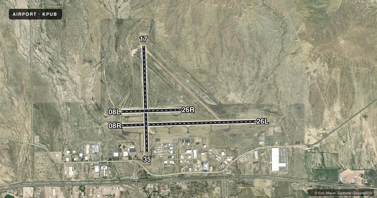
Airport sketch
Runways drawn to scale from FAA survey coordinates, rendered over satellite imagery. Not for navigation.
Approaches & charts
ILS · 2
Services on the field
Fuel grades, oxygen, maintenance, ramp storage and lighting — as declared to the FAA by the airport operator.
Fuel & services
- Fuel
- 100LLA
- Oxygen (bottled)
- High pressure
- Airframe repair
- Major
- Power plant repair
- Major
- Other services
- AGRI,AMB,CHTR,INSTR,RNTL,SALES,SURV
Ramp & ground
- Transient storage
- Tie-down
- Hangar
- Landing fee
- No fee published
- Customs
- Not available
- Lighting schedule
- SEE RMK
- Beacon schedule
- SS-SR
- Beacon
- White / Green (civil land)(WG)
- Wind indicator
- Yes
- Segmented circle
- Yes
Fuel & FBOs
Cheapest 100LL and Jet A on the field and nearby. Always confirm with the FBO before taxi.
Airport notes
Surface conditions, obstructions, local procedures, lighting outages and other notes published with each FAA cycle.
General notes
- HIGH VOLUME TRNG DA-20 ACFT SR-SS MON-FRI. OVERHEAD PATTERN DURG TRNG. EXTENSIVE USE OF TRNG AREA 12-28 DME N-SW OF ARPT 500 FT AGL-8500 FT MSL.
- BE ALERT; INTENSIVE USAF STUDENT TRAINING IN VICINITY OF COLORADO SPRINGS & PUEBLO COLORADO.
- SEE FLIP AP/1 SUPPLEMENTARY ARPT INFO.
- CONDS NOT MNT 2200L-0600L.
- TWY A BTN TWY D AND A6 50 FT WID.
- FOR CD WHEN ATCT CLSD CTC DENVER APCH AT 303-342-1916, WHEN APCH CLSD CTC DENVER ARTCC AT 303-651-4257.
- TXL E 30 FT WIDE BTN TWY E6 AND TWY E7.
- RPD RFL AVBL F/W, R/W DUR FBO HR 0700L-2200L. CTC FBO 719-948-1310 24 HR PN & FREQ 122.95 PRIOR TO LNDG. ADZ ATC FOR RPD RFL OPS & PROCD TO WEST RAMP.
Lighting notes
- WHEN ATCT CLSD ACTVT MALSR RWY 08R; REIL RWY 08L, 17, 26R, 26L & 35; PAPI RWY 08R, 08L, 17, 26R & 35; HIRL RWY 08R/26L; MIRL RWY 08L/26R, 17/35 - CTAF. PAPI RWY 26L ON CONSLY.
Fuel notes
- 100LLAFT HRS (719) 948-1310 OR USE 100LL SELF-SVC.
Runway surface & condition
- 08R/26LPCR VALUE: 517/F/D/X/T
- 17/35PCR VALUE: 610/F/B/X/T
- 08L/26RAVBL TO ACFT UNDER 20000 LBS DURING DALGT AND NIGHT HRS.
VFR map & nearby airports
VFR sectional. Tap any ICAO chip to open that airport.
Key facts · KPUB
Answer card- ICAO
- KPUB
- Name
- PUEBLO MEML
- Location
- PUEBLO, COLORADO
- Elevation
- 4,729.3 ft MSL
- Traffic pattern altitude
- 5,729.3 ft MSL (1,000 AGL)
- Control tower
- Towered · 0600-2200
- Total runways
- 3
- Longest runway
- 08R/26L · 10,498 ft
- Published ILS approaches
- 2
- Published frequencies
- 11
- Magnetic variation
- 8°
- Current flight rules
- VFR
- Current wind
- 300° at 10 kt
- Favored runway now
- RWY 26L
Pueblo Memorial Airport is in Pueblo, Colorado. The field elevation is 4,729.3 ft MSL. It has three asphalt runways. The longest is 08R/26L at 10,498 ft. The tower is open 0600 to 2200 local. Two ILS approaches are published. They serve runway ends 08R and 26L.
Pattern altitude is not published. Use 1,000 ft AGL for light piston traffic unless ATC or the current Chart Supplement says otherwise. That puts the standard pattern around 5,729 ft MSL. This is a busy training field. Expect high volume DA-20 traffic sunrise to sunset Monday through Friday. The remarks also call out intensive U.S. Air Force student training in the Colorado Springs and Pueblo area. Stay sharp in the pattern and on the taxiways.
Freeman Jet Center is on the field. It carries 100LL, Jet A and Jet A Prist. SIBRAN is also on the field. It carries 100LL. Rapid refuel is available during FBO hours from 0700 local to 2200 local. After hours, call the FBO or use 100LL self-service. The airport sits at higher elevation, so performance planning matters. Conditions are not maintained from 2200 local to 0600 local. Check the current Chart Supplement for any noise or curfew restrictions before flying in.