METAR & TAF KMBL
Current METAR
Observed 04:56Z
KMBL 120456Z AUTO 26011KT 10SM FEW037 OVC060 16/15 A2963 RMK AO2 PK WND 26035/0410 RAB09E26 PRESRR SLPNO P0000 T01610150 $
- Wind
- 260° @ 11 kt
- Visibility
- 10 SM
- Temp / Dew
- 16°C / 15°C
- Altimeter
- 29.63 inHg
- Clouds
- OVC
- Density alt
- 1,250 ft
- Ceiling
- 6,000 ft AGL
- Rules
- VFR
Airport info & contacts
Manager on record, flight service, ARTCC, attendance schedule and pattern altitude — published by the FAA and refreshed every 28 days.
Location
- From city
- 3 NM NE
- VFR sectional
- GREEN BAY
- ARTCC
- ZMP · MINNEAPOLIS
- NOTAM facility
- MBL (NOTAM-D)
Airport manager
- Name
- MILES WEAVER
- Phone
- 231-723-4351
- Address
- 2323 AIRPORT RD, MANISTEE MI 49660-9710
Flight service · Hours
- FSS LAN
- LANSING1-800-WX-BRIEF
- Attendance
- NOV-MAR · 0800-1700
- JUN-AUG · 0800-2000
- APR & OCT · 0800-1800
- MAY & SEPT · 0800-1900
Frequencies
Tap any row to copy the frequency to your clipboard.
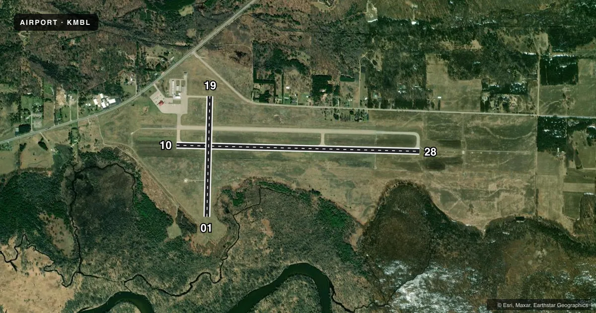
Runways & pattern
Full pagePattern entry · RWY 28
LEFT TRAFFIC| Runway | Heading (°M) | Length | Surface | Traffic |
|---|---|---|---|---|
| 10/28Favored | 85° / 265° | 5,501 ft | ASPH | Standard L |
| 01/19 | 355° / 175° | 2,721 ft | ASPH | Standard L |
Runway end performance
| End | TORA | TODA | ASDA | LDA | VGSI | Approach lights | Obstruction |
|---|---|---|---|---|---|---|---|
| 10 | 5,501' | 5,501' | 5,501' | 5,501' | PAPI 4-box left(3°) | — | 55', tree, 2050' from thr, 100' R of cntrln, slope 33 |
| 28 | 5,501' | 5,501' | 5,501' | 5,501' | PAPI 4-box left(3°) | MALSR | 102', trees, 4350' from thr, 950' R of cntrln, slope 40 |
| 01 | 2,721' | 2,721' | 2,721' | 2,721' | PAPI 2-box left(4°) | — | 8', tree, 312' from thr, 75' R of cntrln, slope 14 |
| 19 | 2,721' | 2,721' | 2,721' | 2,721' | PAPI 2-box left(4°) | — | 49', trees, 1080' from thr, 172' R of cntrln, slope 17 |
Declared distances in feet. TORA = takeoff run available, TODA = takeoff distance, ASDA = accelerate-stop, LDA = landing distance.
Airport sketch
Runways drawn to scale from FAA survey coordinates, rendered over satellite imagery. Not for navigation.
Approaches & charts
ILS · 1
Services on the field
Fuel grades, oxygen, maintenance, ramp storage and lighting — as declared to the FAA by the airport operator.
Fuel & services
- Fuel
- 100LLA
- Airframe repair
- Minor
- Power plant repair
- Minor
Ramp & ground
- Transient storage
- Tie-down
- Hangar
- Landing fee
- No fee published
- Customs
- Not available
- Lighting schedule
- SEE RMK
- Beacon schedule
- SS-SR
- Beacon
- White / Green (civil land)(WG)
- Wind indicator
- Lighted
- Segmented circle
- Yes
Fuel & FBOs
Cheapest 100LL and Jet A on the field and nearby. Always confirm with the FBO before taxi.
Airport notes
Surface conditions, obstructions, local procedures, lighting outages and other notes published with each FAA cycle.
General notes
- BIRDS ON & INVOF ARPT.
- TWY E MKD WITH REFLECTORS.
- ARFF MNT CTAF DRG ACR OPS.
- MAINT PSNL MNT CTAF DRG WORK ON TWYS & RWYS.
- FLD CONDS UNMON AFT ATNDD HRS EXC FOR ACR OPS.
Lighting notes
- ACTVT MALSR RWY 28; REIL RWY 10; PAPI RWY 01, 19, 10, & 28; HIRL RWY 10/28; MIRL RWY 01/19 - CTAF.
Runway surface & condition
- 10/28PCR VALUE: 205/F/C/X/T
- 01/19RWY 01/19 NOT AVBL FOR PART 121/PART 380 OPS WITH SKED PAX CARRYING OPS MORE THAN 9 PAX SEATS AND NON-SKED PAX CARRYING OPS MORE THAN 30 PAX SEATS. NO PART 121/PART 380 OPS EXC FOR TAX.
Approach & departure obstructions
- 19ALSO +15 FT ROAD, 498 FT DIST, APCH RATIO 33:1.
Other notes
- CLSD TO SKED ACR OPS GTR THAN 9 PAX SEATS. 24 HR PPR FOR UNSKED ACR OPS GTR THAN 30 PAX SEATS - CALL AMGR. ARFF UNAVBL EXC ACR & PPR.
VFR map & nearby airports
VFR sectional. Tap any ICAO chip to open that airport.
Key facts · KMBL
Answer card- ICAO
- KMBL
- Name
- MANISTEE COUNTY/BLACKER
- Location
- MANISTEE, MICHIGAN
- Elevation
- 621.4 ft MSL
- Traffic pattern altitude
- 1,621.4 ft MSL (1,000 AGL)
- Control tower
- Non-towered (use CTAF)
- Total runways
- 2
- Longest runway
- 10/28 · 5,501 ft
- Published ILS approaches
- 1
- Published frequencies
- 2
- Magnetic variation
- 6°
- Current flight rules
- VFR
- Current wind
- 260° at 11 kt
- Favored runway now
- RWY 28
Manistee County/Blacker is in Manistee, Michigan. Field elevation is 621.4 ft MSL. The airport has two asphalt runways. The longest is 10/28 at 5,501 ft. There is no control tower. CTAF and UNICOM are both 122.8. One ILS approach is published for runway 28. Pattern altitude is not published, so use standard 1,000 ft AGL for light piston traffic unless the current Chart Supplement says otherwise.
Orchard Beach Aviation is on the field. It carries 100LL and Jet A. Call (231) 723-8095 for current service details before arrival. Published remarks matter here. Runway 28 has MALSR lighting. Runway 10 has REIL. PAPI is published for all runway ends. Runway 10/28 has high intensity lights. Runway 01/19 has medium intensity lights on CTAF. The field also notes birds in and around the airport. Taxiway E is marked with reflectors.
There are a few operational limits to keep in mind. Scheduled passenger operations over 9 seats are closed. Some larger unscheduled passenger operations need 24-hour prior permission. Aircraft rescue and fire fighting is not generally available except for aircraft operations with prior permission. Runway 19 also has a road obstruction on approach. If you are planning a first visit, brief the lighting, the runway 28 ILS and the local traffic picture before you descend into the pattern.