METAR & TAF KLYH
Current METAR
Observed 07:54Z
KLYH 120754Z AUTO 24003KT 10SM CLR 24/19 A2991 RMK AO2 SLP114 T02440194
- Wind
- 240° @ 3 kt
- Visibility
- 10 SM
- Temp / Dew
- 24°C / 19°C
- Altimeter
- 29.91 inHg
- Clouds
- CLR
- Density alt
- 2,256 ft
- Ceiling
- Unlimited
- Rules
- VFR
Airport info & contacts
Manager on record, flight service, ARTCC, attendance schedule and pattern altitude — published by the FAA and refreshed every 28 days.
Location
- From city
- 5 NM SW
- VFR sectional
- CINCINNATI
- ARTCC
- ZDC · WASHINGTON
- NOTAM facility
- LYH (NOTAM-D)
Airport manager
- Name
- CEDRIC SIMON
- Phone
- 434-455-6090
- Address
- 350 TERMINAL DRIVE, SUITE 100, LYNCHBURG VA 24502
Flight service · Hours
- FSS DCA
- LEESBURG1-800-WX-BRIEF
- Attendance
- 0500-2359
Frequencies
Tap any row to copy the frequency to your clipboard.
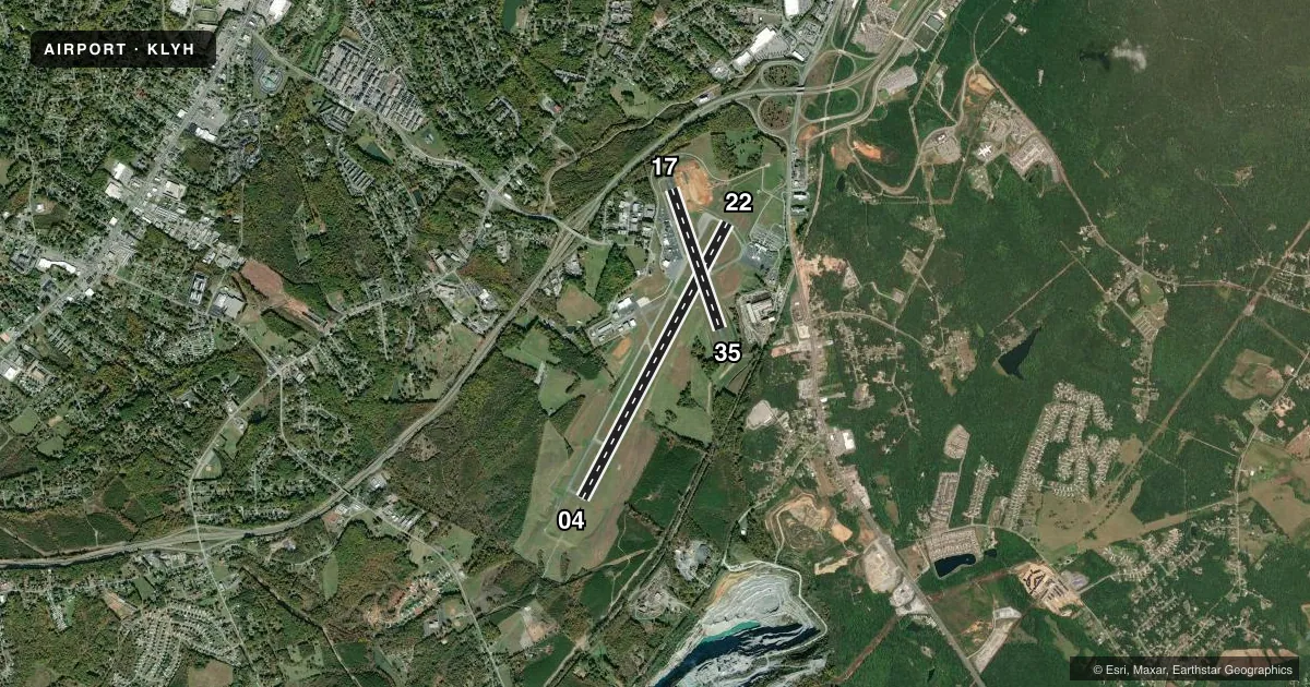
Runways & pattern
Full pagePattern entry · RWY 22
LEFT TRAFFIC| Runway | Heading (°M) | Length | Surface | Traffic |
|---|---|---|---|---|
| 04/22Favored | 20° / 200° | 7,100 ft | ASPH | Standard L |
| 17/35 | 153° / 333° | 3,386 ft | ASPH | Standard L |
Runway end performance
| End | TORA | TODA | ASDA | LDA | VGSI | Approach lights | Obstruction |
|---|---|---|---|---|---|---|---|
| 04 | 7,100' | 7,100' | 6,800' | 6,800' | PAPI 4-box left(3°) | MALSR | — |
| 22 | 7,100' | 7,100' | 7,100' | 7,100' | PAPI 4-box left(3°) | — | — |
| 17 | 3,386' | 3,386' | 3,386' | 3,386' | PAPI 2-box left(4°) | — | — |
| 35 | 3,386' | 3,386' | 3,386' | 3,386' | PAPI 2-box left(4°) | — | — |
Declared distances in feet. TORA = takeoff run available, TODA = takeoff distance, ASDA = accelerate-stop, LDA = landing distance.
Airport sketch
Runways drawn to scale from FAA survey coordinates, rendered over satellite imagery. Not for navigation.
Approaches & charts
ILS · 1
Services on the field
Fuel grades, oxygen, maintenance, ramp storage and lighting — as declared to the FAA by the airport operator.
Fuel & services
- Fuel
- 100LLA
- Oxygen (bottled)
- High pressure
- Oxygen (bulk)
- Not available
- Airframe repair
- Major
- Power plant repair
- Major
- Other services
- AMB,AVNCS,CARGO,CHTR,INSTR,RNTL,SALES
Ramp & ground
- Transient storage
- Tie-down
- Hangar
- Landing fee
- No fee published
- Customs
- Not available
- Lighting schedule
- SEE RMK
- Beacon schedule
- SS-SR
- Beacon
- White / Green (civil land)(WG)
- Wind indicator
- Lighted
- Segmented circle
- No
Fuel & FBOs
Cheapest 100LL and Jet A on the field and nearby. Always confirm with the FBO before taxi.
Airport notes
Surface conditions, obstructions, local procedures, lighting outages and other notes published with each FAA cycle.
General notes
- TWY G UNCONTROLLED-NOT VISIBLE FROM ATCT.
- BIRDS AND OTHER WILDLIFE ON & INVOF ARPT.
- RY 17/35 PPR FOR ACFT OVER 12500 LBS.
- TWY G CLSD TO AIR CARRIER AND ACFT OVER 12500 LBS.
- ALL SURFACES WORK IN PROGRESS MOWING/MAINTENANCE.
- EXTSV FLT TRNG ON AND INVOF ARPT.
- FOR CD WHEN ATCT CLSD CTC ROANOKE APCH AT 540-563-1307.
Lighting notes
- WHEN ATCT CLSD ACTVT MALSR RWY 04; HIRL RWY 04/22; TWY LGTS - CTAF. REIL 17/35; PAPI RWY 17/35; MIRL RWY 17/35 UNAVBL WHEN ATCT CLSD. RWY 04/22 PAPI LGTD 24 HRS.
Runway surface & condition
- 04/22PCR VALUE: 500/F/D/X/T
- 17/35RWY 17/35 NOT AVBL FOR PART 121/PART 380 OPS WITH SKED PAX CARRYING OPS MORE THAN 9 PAX SEATS AND NON-SKED PAX CARRYING OPS MORE THAN 30 PAX SEATS. RY 17/35 300 FT OVERRUN EACH END.
Other notes
- THIS AIRPORT HAS BEEN SURVEYED BY THE NATIONAL GEODETIC SURVEY.
- PPR 12 HRS FOR UNSKED ACR OPNS WITH MORE THAN 30 PSGR SEATS. CALL ARFF 434-582-1157. INDEX "B" COVERAGE PRVDD.
VFR map & nearby airports
VFR sectional. Tap any ICAO chip to open that airport.
Key facts · KLYH
Answer card- ICAO
- KLYH
- Name
- LYNCHBURG RGNL/PRESTON GLENN FLD
- Location
- LYNCHBURG, VIRGINIA
- Elevation
- 938.2 ft MSL
- Traffic pattern altitude
- 1,938.2 ft MSL (1,000 AGL)
- Control tower
- Towered · 0630-2230
- Total runways
- 2
- Longest runway
- 04/22 · 7,100 ft
- Published ILS approaches
- 1
- Published frequencies
- 11
- Magnetic variation
- 8°
- Current flight rules
- VFR
- Current wind
- 240° at 3 kt
- Favored runway now
- RWY 22
KLYH is in Lynchburg, Virginia. The field elevation is 938.2 ft MSL. It has two asphalt runways. The longest is 7,100 ft on 04/22. The tower is open daily from 0630 to 2230. One ILS approach is published for runway 04. Pattern altitude is not published, so use the standard 1,000 ft AGL for light piston traffic unless ATC or the current Chart Supplement says otherwise.
Two FBOs are on the field. Freedom Aviation carries 100LL and Jet A. Lynchburg Regional Airport carries 100LL. If you need current service details, call them directly before arrival. Published remarks also note extensive flight training in the area. Birds and other wildlife are present on and near the airport. Taxiway G is uncontrolled and not visible from the tower, so keep your head on a swivel when moving around the ramp and taxiways.
Runway 17/35 is shorter at 3,386 ft. It also has a 300 ft overrun at each end. The remarks say runway 17/35 is not available for certain larger passenger operations. When the tower is closed, lighting and clearance procedures change. Use the current Chart Supplement and the airport operator for the latest details before a night arrival or any special operation.