METAR & TAF KLWD
Current METAR
Observed 14:53Z
KLWD 121453Z AUTO 28009KT 10SM CLR 23/13 A3004 RMK AO2 SLP164 T02280128 51013
- Wind
- 280° @ 9 kt
- Visibility
- 10 SM
- Temp / Dew
- 23°C / 13°C
- Altimeter
- 30.04 inHg
- Clouds
- CLR
- Density alt
- 2,213 ft
- Ceiling
- Unlimited
- Rules
- VFR
Airport info & contacts
Manager on record, flight service, ARTCC, attendance schedule and pattern altitude — published by the FAA and refreshed every 28 days.
Location
- From city
- 2 NM NE
- VFR sectional
- CHICAGO
- ARTCC
- ZMP · MINNEAPOLIS
- NOTAM facility
- LWD (NOTAM-D)
Airport manager
- Name
- JORDAN OMSTEAD
- Phone
- (719) 648-9924
- Address
- 190 SOUTH CHESTNUT STREET, LAMONI IA 50140
Flight service · Hours
- FSS FOD
- FORT DODGE1-800-WX-BRIEF
- Attendance
- Unattended
Frequencies
Tap any row to copy the frequency to your clipboard.
Runways & pattern
Full pagePattern entry · RWY 36
LEFT TRAFFICRunway end performance
| End | TORA | TODA | ASDA | LDA | VGSI | Approach lights | Obstruction |
|---|---|---|---|---|---|---|---|
| 18 | — | — | — | — | — | — | 7', tree, 340' from thr, 0' R of cntrln, slope 20 |
| 36 | — | — | — | — | — | — | 9', trees, 324' from thr, 3' R of cntrln, slope 13 |
Declared distances in feet. TORA = takeoff run available, TODA = takeoff distance, ASDA = accelerate-stop, LDA = landing distance.
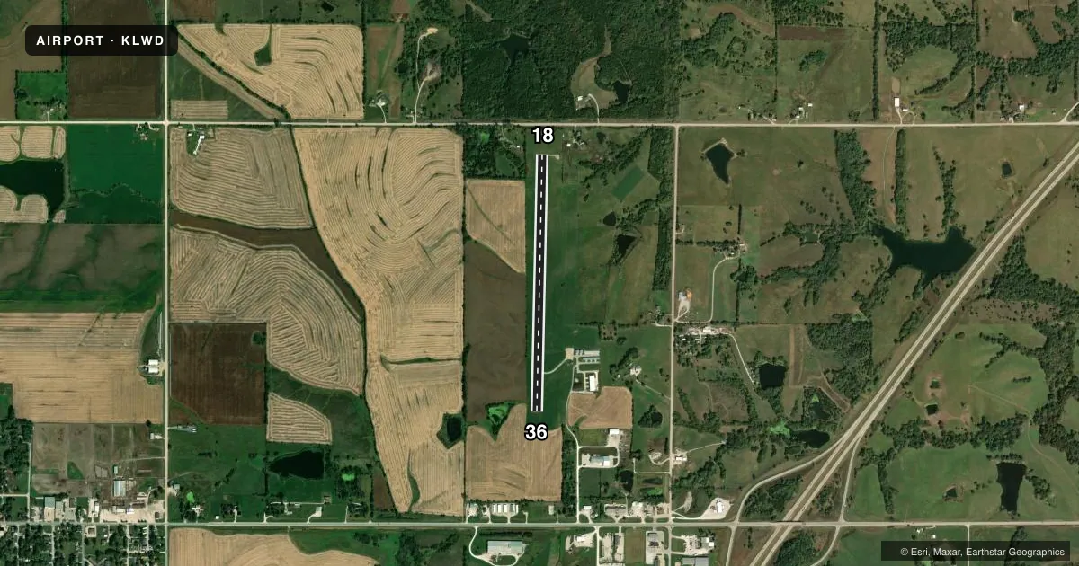
Airport sketch
Runways drawn to scale from FAA survey coordinates, rendered over satellite imagery. Not for navigation.
Approaches & charts
Services on the field
Fuel grades, oxygen, maintenance, ramp storage and lighting — as declared to the FAA by the airport operator.
Fuel & services
- Fuel
- 100LL
- Oxygen (bottled)
- Not available
- Oxygen (bulk)
- Not available
- Airframe repair
- Not available
- Power plant repair
- Not available
Ramp & ground
- Transient storage
- Tie-down
- Hangar
- Landing fee
- No fee published
- Lighting schedule
- SEE RMK
- Beacon schedule
- SS-SR
- Beacon
- White / Green (civil land)(WG)
- Wind indicator
- Lighted
- Segmented circle
- No
Fuel & FBOs
Cheapest 100LL and Jet A on the field and nearby. Always confirm with the FBO before taxi.
Airport notes
Surface conditions, obstructions, local procedures, lighting outages and other notes published with each FAA cycle.
General notes
- ULTRALIGHTS ON & INVOF ARPT.
- FOR CD CTC MINNEAPOLIS ARTCC AT 651-463-5588.
Lighting notes
- ACTVT MIRL RY 18/36 - 122.9.
Fuel notes
- 100LLSELF SERVICE FUEL 24 HRS. CREDIT CARD
VFR map & nearby airports
VFR sectional. Tap any ICAO chip to open that airport.
Key facts · KLWD
Answer card- ICAO
- KLWD
- Name
- LAMONI MUNI
- Location
- LAMONI, IOWA
- Elevation
- 1,130.6 ft MSL
- Traffic pattern altitude
- 2,130.6 ft MSL (1,000 AGL)
- Control tower
- Non-towered (use CTAF)
- Total runways
- 1
- Longest runway
- 18/36 · 3,400 ft
- Published ILS approaches
- 0
- Published frequencies
- 1
- Magnetic variation
- 3°
- Current flight rules
- VFR
- Current wind
- 280° at 9 kt
- Favored runway now
- RWY 36
Lamoni Muni (KLWD) sits in Lamoni, Iowa. The field elevation is 1,130.6 ft MSL. It has one runway, 18/36, which is 3,400 ft long with concrete pavement. There is no control tower. CTAF is 122.9. No ILS approaches are published here.
Pattern altitude is not published. Use the standard 1,000 ft AGL pattern unless the current Chart Supplement says otherwise. The airport has one on-field FBO listed as Lamoni Municipal Airport. It carries 100LL. Self-service fuel is available 24 hours with credit card payment.
A few operational notes matter here. Ultralight aircraft operate on and near the airport. Medium intensity runway lights on 18/36 are activated by radio on 122.9. For clearance delivery, contact Minneapolis Air Route Traffic Control Center. First-time visitors should plan for an uncontrolled field with local traffic on CTAF. Check the current Chart Supplement before departure for any updated remarks or procedures.