METAR & TAF KIML
Current METAR
Observed 12:53Z
KIML 271253Z AUTO 04012KT 10SM CLR 27/19 A2991 RMK AO2 SLP079 T02720189
- Wind
- 040° @ 12 kt
- Visibility
- 10 SM
- Temp / Dew
- 27°C / 19°C
- Altimeter
- 29.91 inHg
- Clouds
- CLR
- Density alt
- 5,515 ft
- Ceiling
- Unlimited
- Rules
- VFR
Airport info & contacts
Manager on record, flight service, ARTCC, attendance schedule and pattern altitude — published by the FAA and refreshed every 28 days.
Location
- From city
- 1 NM SE
- VFR sectional
- CHEYENNE
- ARTCC
- ZDV · DENVER
- NOTAM facility
- IML (NOTAM-D)
Airport manager
- Name
- ADRIAN FOREMAN
- Phone
- 308-414-3002
- Address
- P.O. BOX 637, IMPERIAL NE 69033-0637
Flight service · Hours
- FSS OLU
- COLUMBUS1-800-WX-BRIEF
- Attendance
- MON-FRI · 0800-1700
Frequencies
Tap any row to copy the frequency to your clipboard.
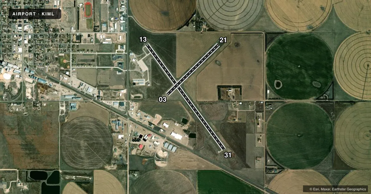
Runways & pattern
Full pagePattern entry · RWY 03
LEFT TRAFFIC| Runway | Heading (°M) | Length | Surface | Traffic |
|---|---|---|---|---|
| 13/31 | 135° / 315° | 5,022 ft | CONC | Standard L |
| 03/21Favored | 37° / 217° | 2,756 ft | TURF | Standard L |
Runway end performance
| End | TORA | TODA | ASDA | LDA | VGSI | Approach lights | Obstruction |
|---|---|---|---|---|---|---|---|
| 13 | — | — | — | — | PAPI 2-box left(3°) | — | — |
| 31 | — | — | — | — | PAPI 2-box left(3°) | — | — |
Declared distances in feet. TORA = takeoff run available, TODA = takeoff distance, ASDA = accelerate-stop, LDA = landing distance.
Airport sketch
Runways drawn to scale from FAA survey coordinates, rendered over satellite imagery. Not for navigation.
Approaches & charts
Services on the field
Fuel grades, oxygen, maintenance, ramp storage and lighting — as declared to the FAA by the airport operator.
Fuel & services
- Fuel
- 100LL
- Oxygen (bottled)
- Not available
- Oxygen (bulk)
- Not available
- Other services
- AGRI
Ramp & ground
- Transient storage
- Tie-down
- Landing fee
- No fee published
- Customs
- Not available
- Lighting schedule
- SEE RMK
- Beacon schedule
- SS-SR
- Beacon
- White / Green (civil land)(WG)
- Wind indicator
- Lighted
- Segmented circle
- Yes
Fuel & FBOs
Cheapest 100LL and Jet A on the field and nearby. Always confirm with the FBO before taxi.
Airport notes
Surface conditions, obstructions, local procedures, lighting outages and other notes published with each FAA cycle.
General notes
- BIRDS INVOF ARPT - SEASONAL.
- EXTENSIVE CROP SPRAYING OPNS INVOF ARPT APR THRU AUG.
- RY 03/21 NOT PLOWED WINTER MONTHS.
- FOR CD CTC DENVER ARTCC AT 303-651-4257.
Lighting notes
- ACTVT MIRL RY 13/31 PAPI RY 13 & 31 AND REIL RY 13 & 31 - CTAF.
Fuel notes
- 100LLFUEL AVBL H24 VIA CREDIT CARD.
Other notes
- EXISTED PRIOR TO 1959.
- 4 FT X 8 FT CONCRETE MARKER SEGMENTS.
- MANAGERRICK CHANDLER AMGR APR-SEPT.
- MANAGERCTC FOR BOTH AMGRS.
VFR map & nearby airports
VFR sectional. Tap any ICAO chip to open that airport.
Key facts · KIML
Answer card- ICAO
- KIML
- Name
- IMPERIAL MUNI
- Location
- IMPERIAL, NEBRASKA
- Elevation
- 3,276 ft MSL
- Traffic pattern altitude
- 4,276 ft MSL (1,000 AGL)
- Control tower
- Non-towered (use CTAF)
- Total runways
- 2
- Longest runway
- 13/31 · 5,022 ft
- Published ILS approaches
- 0
- Published frequencies
- 2
- Magnetic variation
- 9°
- Current flight rules
- VFR
- Current wind
- 040° at 12 kt
- Favored runway now
- RWY 03
Imperial Muni is in Imperial, Nebraska. The field elevation is 3,276 ft MSL. It has two runways. The longest is 13/31 at 5,022 ft. There is no control tower. CTAF and UNICOM are both 122.8. No ILS approaches are published here.
Pattern altitude is not published. Plan on the standard 1,000 ft AGL unless the current Chart Supplement says otherwise. That puts the light piston pattern at 4,276 ft MSL. The airport sits in southwest Nebraska, so density altitude can matter in warm weather. The elevation is already high enough to notice performance changes on takeoff.
The on-field FBO is Imperial Municipal Airport. It carries 100LL. 100LL is available 24 hours a day via credit card. The published remarks also note seasonal bird activity near the airport. Runway 03/21 is not plowed in winter. Crop spraying operations are common from April through August, so expect extra traffic in the area. Runway 13/31 has medium intensity lights, PAPI and REILs. REILs are activated via CTAF. For clearance delivery, contact Denver ARTCC at 303-651-4257. If you need current local procedures or any restriction details, check the current FAA Chart Supplement or call the airport operator before departure.