METAR & TAF KIAG
Current METAR
Observed 16:53Z
KIAG 271653Z 20008KT 10SM CLR 27/19 A2982 RMK AO2 SLP092 T02670189
- Wind
- 200° @ 8 kt
- Visibility
- 10 SM
- Temp / Dew
- 27°C / 19°C
- Altimeter
- 29.82 inHg
- Clouds
- CLR
- Density alt
- 2,298 ft
- Ceiling
- Unlimited
- Rules
- VFR
Airport info & contacts
Manager on record, flight service, ARTCC, attendance schedule and pattern altitude — published by the FAA and refreshed every 28 days.
Location
- From city
- 4 NM E
- VFR sectional
- DETROIT
- ARTCC
- ZOB · CLEVELAND
- NOTAM facility
- IAG (NOTAM-D)
Airport manager
- Name
- MR. JAMES CELESTE
- Phone
- (716) 297-4494
- Address
- 2035 NIAGARA FALLS BLVD, NIAGARA FALLS NY 14304
Flight service · Hours
- FSS BUF
- BUFFALO1-800-WX-BRIEF
- Attendance
- ALL
Frequencies
Tap any row to copy the frequency to your clipboard.
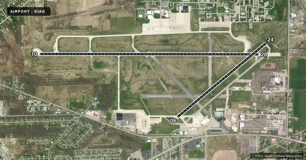
Runways & pattern
Full pagePattern entry · RWY 24
LEFT TRAFFIC| Runway | Heading (°M) | Length | Surface | Traffic |
|---|---|---|---|---|
| 10/28 | 80° / 260° | 9,826 ft | ASPH-CONC | Standard L |
| 06/24Favored | 40° / 220° | 5,188 ft | ASPH | Standard L |
Runway end performance
| End | TORA | TODA | ASDA | LDA | VGSI | Approach lights | Obstruction |
|---|---|---|---|---|---|---|---|
| 10 | 9,829' | 10,829' | 9,829' | 9,129' | PAPI 4-box left(2.89°) | — | 52', tree, 840' from thr, 480' R of cntrln, slope 12 |
| 28 | 9,829' | 10,529' | 9,129' | 9,129' | PAPI 4-box left(2.5°) | MALSR | 37', tree, 1425' from thr, 400' R of cntrln, slope 33 |
| 06 | 5,188' | 5,188' | 5,188' | 5,188' | PAPI 4-box left(3°) | — | 46', tree, 740' from thr, 290' R of cntrln, slope 11 |
| 24 | 5,188' | 5,188' | 5,108' | 5,108' | PAPI 4-box left(3°) | — | 59', tree, 1750' from thr, 320' R of cntrln, slope 26 |
Declared distances in feet. TORA = takeoff run available, TODA = takeoff distance, ASDA = accelerate-stop, LDA = landing distance.
Airport sketch
Runways drawn to scale from FAA survey coordinates, rendered over satellite imagery. Not for navigation.
Approaches & charts
ILS · 1
Services on the field
Fuel grades, oxygen, maintenance, ramp storage and lighting — as declared to the FAA by the airport operator.
Fuel & services
- Fuel
- 100LLAA+
- Oxygen (bottled)
- Not available
- Oxygen (bulk)
- Not available
- Airframe repair
- Minor
- Power plant repair
- Minor
- Other services
- AFRT,CARGO,CHTR,INSTR,RNTL,SALES
Ramp & ground
- Transient storage
- Tie-down
- Landing fee
- Yes
- Customs
- Not available
- Lighting schedule
- SEE RMK
- Beacon schedule
- SS-SR
- Beacon
- White / Green (civil land)(WG)
- Wind indicator
- Lighted
- Segmented circle
- No
Fuel & FBOs
Cheapest 100LL and Jet A on the field and nearby. Always confirm with the FBO before taxi.
Airport notes
Surface conditions, obstructions, local procedures, lighting outages and other notes published with each FAA cycle.
General notes
- EXTSV ACFT ACTIVITY OPERATING INVOF US/CANADIAN FALLS ALL ALTS.
- CAUTION: HEAVY CONCENTRATIONS OF GULLS-BLACKBIRDS-STARLINGS UP TO 5000 AGL ON & INVOF ARPT. BASH PHASE II OPERATIONS AT KIAG MAR-MAY AND SEP-NOV.
- TWY D3 RSTRD TO 12500 LBS OR LESS.
- ALL MIL ACFT ONLY OPNS RESTRICTED DURING BIRD WATCH CONDITIONS. MODERATE - TKOF & LDG PERMISSION ONLY WNEN DEP/ARR RTE AVOIDS IDENTIFIED BIRD ACTIVITY; NO LCL IFR/VFR TFC PAT ACTIVITY. SEVERE - TKOF & LDG PHOHIBITED WO OG/CC APPROVAL; CTC COMMAND POST FOR CURRENT BIRD WATCH CONDITIONS.
- ALL MIL ACFT ONLY MINIMAL CLASSIFIED MATERIALS AVBL; AIRCREWS SHOULD ARRIVE WITH APPROPRIATE AMOUNT TO COMPLETE THEIR MISSION.
- BEARING STRENGTH RWY 06/24: ST110 TT145 SBTT281 TDT415 TRT252.
- JASU: 2(A/M32A-86) 1(AM32A-60) 1(MA-1A).
- FUEL: J8, A++ (MIL).
- FLUID: SP.
- OIL: O-148(MIL).
- MISC: LOCAL MISSION AIRCRAFT HAVE PRIORITY FOR DEICING; MILITARY SIDE ONLY ACFT DE-ICING LIMITED TO KC-135R ONLY.
- MILITARY: MISC: FOR CURRENT MIL RWY CONDITION READING (RCR) CALL OR CTC 914 ARW COMD POST OR 914TH ARW AFLD MANAGEMENT.
- PPR CTC AFLD MGT DSN: 238-2176, C716-236-2176. AFLD MGMT RQR 48 HR ADVANCE NOTICE FOR PPR AND WILL ARRANGE U.S. CUSTOMS IF NEEDED. U.S. CUSTOMS NOT ON STATION.
- AFLD MGMT DOES NOT ISSUE OR STORE COMSEC, FOR COMSEC STORAGE CTC COMMAND POST DSN 238-2150, C716-236-2150.
- RWY 28 1000 FT X 150 FT BLAST PAD.
- MILITARY: AFRC: AIRFIELD OPS SVC 1200-0400Z++ MON-FRI EXC HOL. NSTD OPS APN MRKS IDENTIFYING PRKG ROW AND PRKG LCTN. NSTD MAIN APN MRK EAST SIDE, PRK STOP BAR AND ACFT GND EQPT (AGE) BOX. CSTMS/AG/IMG SVC NOT LCTD ON NIAGARA FALLS ARS. SVC AVBL H24. OPS APRON WEST STANCHION LIGHTS UNSVC. USE CAUTION DUR NGT TIME OPS.
- INTXN DEPS RWY 24 AT TWY D1 ARE NA.
- TWY A, A1, A2, A3, M & L NON-MOV AREAS.
- PILOTS ARE REMINDED TO REVIEW ARPT HOTSPOT INFO BFR TXG FOR DEP & BFR LNDG. SEE TPP ARPT DIAGRAM AND CHART SUPPL SXN ON HOTSPOTS FOR ADDNL INFO.
- FOR CD WHEN ATCT CLSD CTC BUFFALO ATCT ON FREQ OR 716-626-6920.
- PAJA OPNS SR-SS. CALL AMGR FOR MORE INFO.
Lighting notes
- WHEN ATCT CLSD ACTVT MALSR RWY 28; REIL RWY 06, 24; CNTRLN RWY 10/28; PAPI RWY 06, 24, 10; HIRL RWY 10/28; MIRL RWY 06/24; TWY LGTS - CTAF
Runway surface & condition
- 06/24PCR VALUE: 2540/F/B/X/T
- 10/28PCR VALUE: 4110/F/B/X/T
Approach & departure obstructions
- 10APCH RATIO 29:1 TO DTHR.
Other notes
- ARFF INDEX E EQUIPMENT COVERAGE PROVIDED.
- PARKING FEE.
- 10/28RWY 28 ROLLOUT END OF RWY- LAST 900 FT NOT GROOVED.
VFR map & nearby airports
VFR sectional. Tap any ICAO chip to open that airport.
Key facts · KIAG
Answer card- ICAO
- KIAG
- Name
- NIAGARA FALLS INTL
- Location
- NIAGARA FALLS, NEW YORK
- Elevation
- 592.3 ft MSL
- Traffic pattern altitude
- 1,592.3 ft MSL (1,000 AGL)
- Control tower
- Towered · 0700-2300
- Total runways
- 2
- Longest runway
- 10/28 · 9,826 ft
- Published ILS approaches
- 1
- Published frequencies
- 14
- Magnetic variation
- 10°
- Current flight rules
- VFR
- Current wind
- 200° at 8 kt
- Favored runway now
- RWY 24
Niagara Falls Intl sits in Niagara Falls, New York. Field elevation is 592.3 ft MSL. It has 2 runways. The longest is 10/28 at 9,826 ft. The airport is towered. The tower is open 0700-2300. One ILS approach is published for runway 28.
Pattern altitude is not published. Use the standard 1,000 ft AGL for light piston traffic unless ATC or the current Chart Supplement says otherwise. The field is busy. Published remarks call out extensive aircraft activity around the US and Canadian falls at all altitudes. Expect a lot of traffic in the area.
Calspan Air Services is on the field. It carries 100LL, Jet A and Jet A Prist. The airport also notes SP fluids are available. Runway 10/28 has a grooved surface except for the last 900 ft of the rollout end on runway 28. Taxiways A, A1, A2, A3, M and L are non-movement areas, so brief your ground handling carefully. This is a good airport to review for tower procedures, runway selection and traffic flow before arrival. Check the current FAA Chart Supplement for any noise or local operating notes before you go.