METAR & TAF KHKS
Current METAR
Observed 12:53Z
KHKS 271253Z 28005KT 10SM CLR 27/24 A3001 RMK AO2 SLP153 T02720239
- Wind
- 280° @ 5 kt
- Visibility
- 10 SM
- Temp / Dew
- 27°C / 24°C
- Altimeter
- 30.01 inHg
- Clouds
- CLR
- Density alt
- 1,752 ft
- Ceiling
- Unlimited
- Rules
- VFR
Airport info & contacts
Manager on record, flight service, ARTCC, attendance schedule and pattern altitude — published by the FAA and refreshed every 28 days.
Location
- From city
- 3 NM NW
- VFR sectional
- MEMPHIS
- ARTCC
- ZME · MEMPHIS
- NOTAM facility
- HKS (NOTAM-D)
Airport manager
- Name
- PATRICK MINOR
- Phone
- 601-939-5631
- Address
- PO BOX 98109, JACKSON MS 39298-8109
Flight service · Hours
- FSS GWO
- GREENWOOD1-800-WX-BRIEF
- Attendance
- 0700-2100
Frequencies
Tap any row to copy the frequency to your clipboard.
Runways & pattern
Full pagePattern entry · RWY 29
LEFT TRAFFIC| Runway | Heading (°M) | Length | Surface | Traffic |
|---|---|---|---|---|
| 16/34 | 159° / 339° | 5,387 ft | ASPH | Standard L |
| 11/29Favored | 115° / 295° | 3,431 ft | CONC | Standard L |
Runway end performance
| End | TORA | TODA | ASDA | LDA | VGSI | Approach lights | Obstruction |
|---|---|---|---|---|---|---|---|
| 16 | — | — | — | — | PAPI 4-box left(3°) | MALS | — |
| 34 | — | — | — | — | — | — | 44', trees, 1300' from thr, 210' R of cntrln, slope 25 |
| 11 | 4,021' | 4,400' | 4,250' | 3,431' | — | — | 28', pline, 1440' from thr, 0' R of cntrln, slope 44 |
| 29 | 3,810' | 4,400' | 3,810' | 3,431' | — | — | 56', trees, 1693' from thr, 200' R of cntrln, slope 26 |
Declared distances in feet. TORA = takeoff run available, TODA = takeoff distance, ASDA = accelerate-stop, LDA = landing distance.
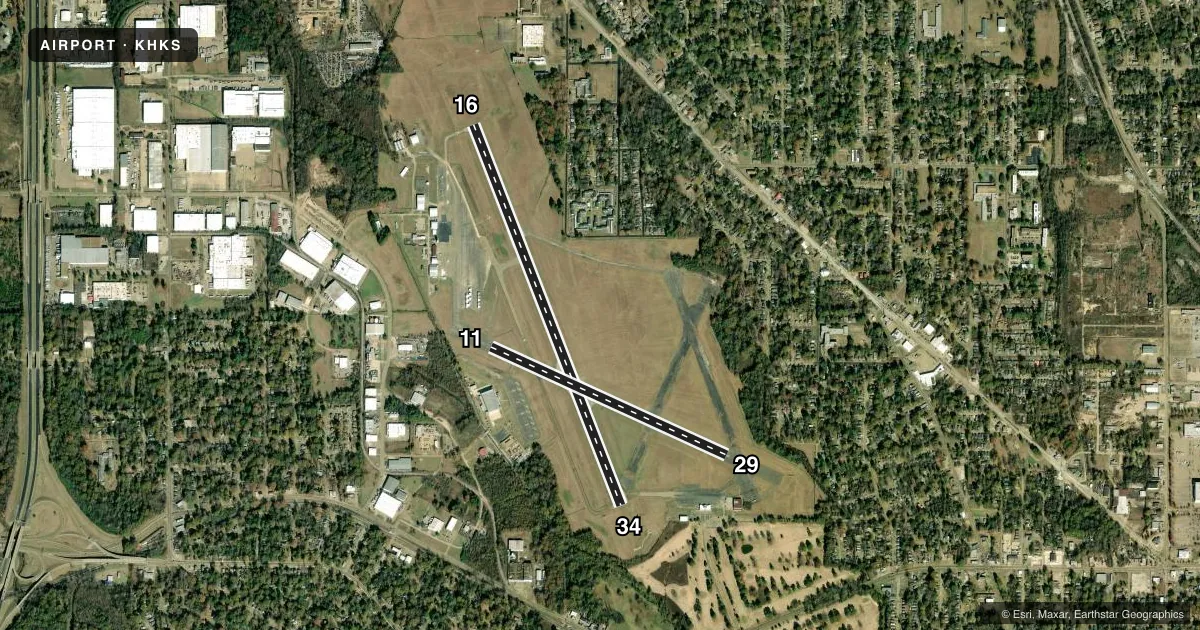
Airport sketch
Runways drawn to scale from FAA survey coordinates, rendered over satellite imagery. Not for navigation.
Approaches & charts
ILS · 1
Services on the field
Fuel grades, oxygen, maintenance, ramp storage and lighting — as declared to the FAA by the airport operator.
Fuel & services
- Fuel
- 100LLA+
- Oxygen (bottled)
- Not available
- Oxygen (bulk)
- Not available
- Airframe repair
- Major
- Power plant repair
- Major
- Other services
- AFRT,AMB,CHTR,INSTR,RNTL,SALES
Ramp & ground
- Transient storage
- Tie-down
- Hangar
- Landing fee
- No fee published
- Customs
- Not available
- Lighting schedule
- SEE RMK
- Beacon schedule
- SS-SR
- Beacon
- White / Green (civil land)(WG)
- Wind indicator
- Lighted
- Segmented circle
- Yes
Fuel & FBOs
Cheapest 100LL and Jet A on the field and nearby. Always confirm with the FBO before taxi.
Airport notes
Surface conditions, obstructions, local procedures, lighting outages and other notes published with each FAA cycle.
General notes
- ARNG OPS 1300-2230Z++.
- TWYS F & G CLSD INDEFLY.
- S APN NOT LGTD.
- PAEW RWYS NGTLY BY NOTAM.
- WHEN APCH CLSD, FOR CD CTC MEMPHIS ARTCC AT 901-368-8453/8449.
Lighting notes
- ACTVT MALS RWY 16; REIL RWY 34; HIRL 16/34 - CTAF. MIRL RWY 11/29 ATCT-CTL. WHEN ATCT CLSD MIRL RWY 11/29 UNAVBL.
Other notes
- THIS AIRPORT HAS BEEN SURVEYED BY THE NATIONAL GEODETIC SURVEY.
- PILOTS MUST PRVD TIEDOWN ROPES.
VFR map & nearby airports
VFR sectional. Tap any ICAO chip to open that airport.
Key facts · KHKS
Answer card- ICAO
- KHKS
- Name
- HAWKINS FLD
- Location
- JACKSON, MISSISSIPPI
- Elevation
- 341.3 ft MSL
- Traffic pattern altitude
- 1,341.3 ft MSL (1,000 AGL)
- Control tower
- Towered · 0700-2100
- Total runways
- 2
- Longest runway
- 16/34 · 5,387 ft
- Published ILS approaches
- 1
- Published frequencies
- 10
- Magnetic variation
- 0°
- Current flight rules
- VFR
- Current wind
- 280° at 5 kt
- Favored runway now
- RWY 29
Hawkins Fld sits in Jackson, Mississippi. Field elevation is 341.3 ft MSL. The airport has two runways. The longest is 16/34 at 5,387 ft. It also has 11/29 at 3,431 ft. The tower is open 0700-2100. One ILS is published for runway 16. Pattern altitude is not published, so use the standard 1,000 ft AGL for light piston operations unless ATC or the Chart Supplement says otherwise.
Skyport Aviation is on the field. It carries 100LL, Jet A and Jet A Prist. Call them at (601) 948-8778 for current service details. The airport remarks also note that tiedown ropes must be provided by pilots. Taxiways F and G are closed indefinitely. The south apron is not lighted.
For lighting, runway 16 has medium intensity approach lighting. Runway 34 has runway end identifier lights. High intensity runway lights are on 16 and 34. They are controlled by CTAF. Runways 11 and 29 have medium intensity runway lights. Those are tower controlled. When the tower is closed, the lights on 11 and 29 are unavailable. This field is in Jackson. Expect busy traffic and stay sharp on the radio. Check current procedures before arrival if you plan a night or low-visibility stop.