METAR & TAF KHKA
Current METAR
Observed 23:53Z
KHKA 112353Z AUTO 20014KT 10SM BKN060 32/21 A2984 RMK AO2 SLP101 T03170211 10344 20317 56008 PWINO $
- Wind
- 200° @ 14 kt
- Visibility
- 10 SM
- Temp / Dew
- 32°C / 21°C
- Altimeter
- 29.84 inHg
- Clouds
- BKN
- Density alt
- 2,456 ft
- Ceiling
- 6,000 ft AGL
- Rules
- VFR
Airport info & contacts
Manager on record, flight service, ARTCC, attendance schedule and pattern altitude — published by the FAA and refreshed every 28 days.
Location
- From city
- 3 NM E
- VFR sectional
- MEMPHIS
- ARTCC
- ZME · MEMPHIS
- NOTAM facility
- HKA (NOTAM-D)
Airport manager
- Name
- JUSTIN BAGLEY
- Phone
- 870-763-0200
- Address
- 5349 N STATE HWY 980, BLYTHEVILLE AR 72315
Flight service · Hours
- FSS JBR
- JONESBORO1-800-WX-BRIEF
- Attendance
- 0730-1730
Frequencies
Tap any row to copy the frequency to your clipboard.
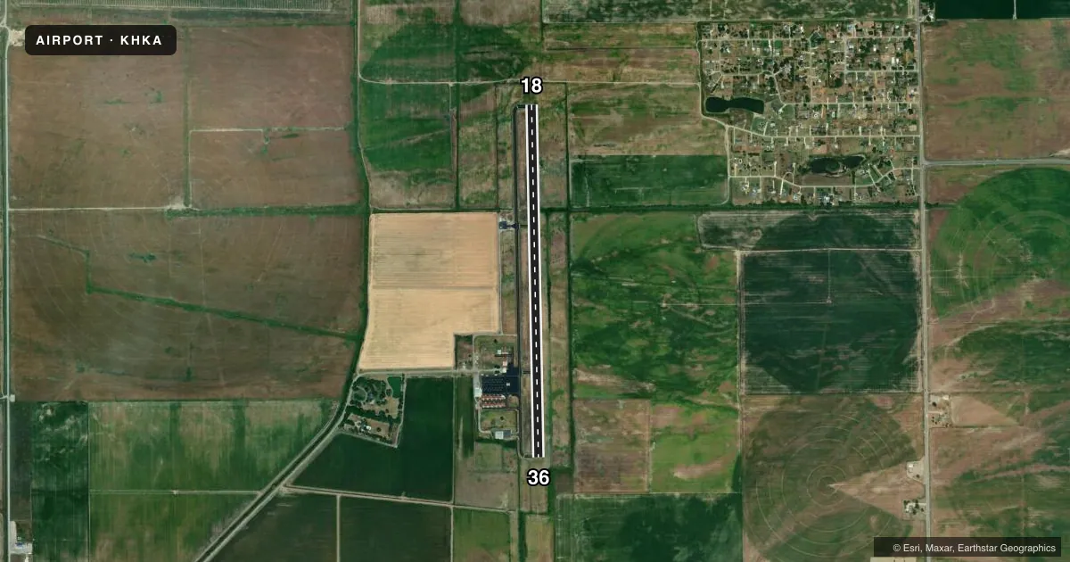
Runways & pattern
Full pagePattern entry · RWY 18
LEFT TRAFFICRunway end performance
| End | TORA | TODA | ASDA | LDA | VGSI | Approach lights | Obstruction |
|---|---|---|---|---|---|---|---|
| 18 | — | — | — | — | PAPI 4-box left(3°) | — | — |
| 36 | — | — | — | — | PAPI 4-box left(3°) | — | — |
Declared distances in feet. TORA = takeoff run available, TODA = takeoff distance, ASDA = accelerate-stop, LDA = landing distance.
Airport sketch
Runways drawn to scale from FAA survey coordinates, rendered over satellite imagery. Not for navigation.
Approaches & charts
Services on the field
Fuel grades, oxygen, maintenance, ramp storage and lighting — as declared to the FAA by the airport operator.
Fuel & services
- Fuel
- 100LLA
- Oxygen (bottled)
- Not available
- Oxygen (bulk)
- Not available
- Airframe repair
- Minor
- Power plant repair
- Minor
- Other services
- AGRI,INSTR,RNTL
Ramp & ground
- Transient storage
- Tie-down
- Hangar
- Landing fee
- No fee published
- Customs
- Not available
- Lighting schedule
- SEE RMK
- Beacon schedule
- SS-SR
- Beacon
- White / Green (civil land)(WG)
- Wind indicator
- Lighted
- Segmented circle
- Yes
Fuel & FBOs
Cheapest 100LL and Jet A on the field and nearby. Always confirm with the FBO before taxi.
Airport notes
Surface conditions, obstructions, local procedures, lighting outages and other notes published with each FAA cycle.
General notes
- NMRS AGRICULTURAL ACFT OPS FM FEB-NOV 250 FT AGL AND BLO. RIGHT & LEFT TPA.
- FOR CD CTC MEMPHIS ARTCC AT 901-368-8453/8449.
Lighting notes
- ACTVT MIRL RWY 18/36 - CTAF. PAPI RWYS 18 & 36 OPR CONSLY.
Other notes
- LGT TEMPORARILY OTS.
- 1FOR ARPT ATTENDANT AFT HRS CALL 870-532-7309.
VFR map & nearby airports
VFR sectional. Tap any ICAO chip to open that airport.
Key facts · KHKA
Answer card- ICAO
- KHKA
- Name
- BLYTHEVILLE MUNI
- Location
- BLYTHEVILLE, ARKANSAS
- Elevation
- 255.7 ft MSL
- Traffic pattern altitude
- 1,255.7 ft MSL (1,000 AGL)
- Control tower
- Non-towered (use CTAF)
- Total runways
- 1
- Longest runway
- 18/36 · 5,002 ft
- Published ILS approaches
- 0
- Published frequencies
- 2
- Magnetic variation
- 1°
- Current flight rules
- VFR
- Current wind
- 200° at 14 kt
- Favored runway now
- RWY 18
Blytheville Muni is in Blytheville, Arkansas. Field elevation is 255.7 ft MSL. The airport has one runway, 18/36, which is 5,002 ft long. There is no control tower. CTAF and UNICOM are both 123.05.
No ILS approaches are published here. The pattern altitude is not published in the facts, so use the current Chart Supplement before you fly the pattern. North Delta Aviation is on the field. It carries 100LL and Jet A. Call them at (870) 763-0200 for current service details.
A few operational notes matter here. Agricultural aircraft operations are common from February through November. They may be working as low as 250 ft AGL and below in the traffic pattern area. The light wind indicator is temporarily out of service. Runway 18/36 has medium intensity lights that are activated by CTAF. The PAPI on both runway ends operates continuously. For clearance delivery, Memphis ARTCC can be reached at 901-368-8453 or 901-368-8449. If you are arriving after hours, call the airport attendant at 870-532-7309.