METAR & TAF KGNB
Current METAR
Observed 18:55Z
KGNB 271855Z AUTO 04004KT 10SM BKN080 OVC110 26/10 A3041 RMK AO2 T02600096
- Wind
- 040° @ 4 kt
- Visibility
- 10 SM
- Temp / Dew
- 26°C / 10°C
- Altimeter
- 30.41 inHg
- Clouds
- OVC
- Density alt
- 10,889 ft
- Ceiling
- 8,000 ft AGL
- Rules
- VFR
Airport info & contacts
Manager on record, flight service, ARTCC, attendance schedule and pattern altitude — published by the FAA and refreshed every 28 days.
Location
- From city
- 1 NM NE
- VFR sectional
- CHEYENNE
- ARTCC
- ZDV · DENVER
- NOTAM facility
- DEN (NOTAM-D)
Airport manager
- Name
- SHAWN MAHORNEY
- Phone
- 970-887-2123
- Address
- P O BOX 264, HOT SULPHUR SPRINGS CO 80451
Flight service · Hours
- FSS DEN
- DENVER1-800-WX-BRIEF
- Attendance
- Unattended
Frequencies
Tap any row to copy the frequency to your clipboard.
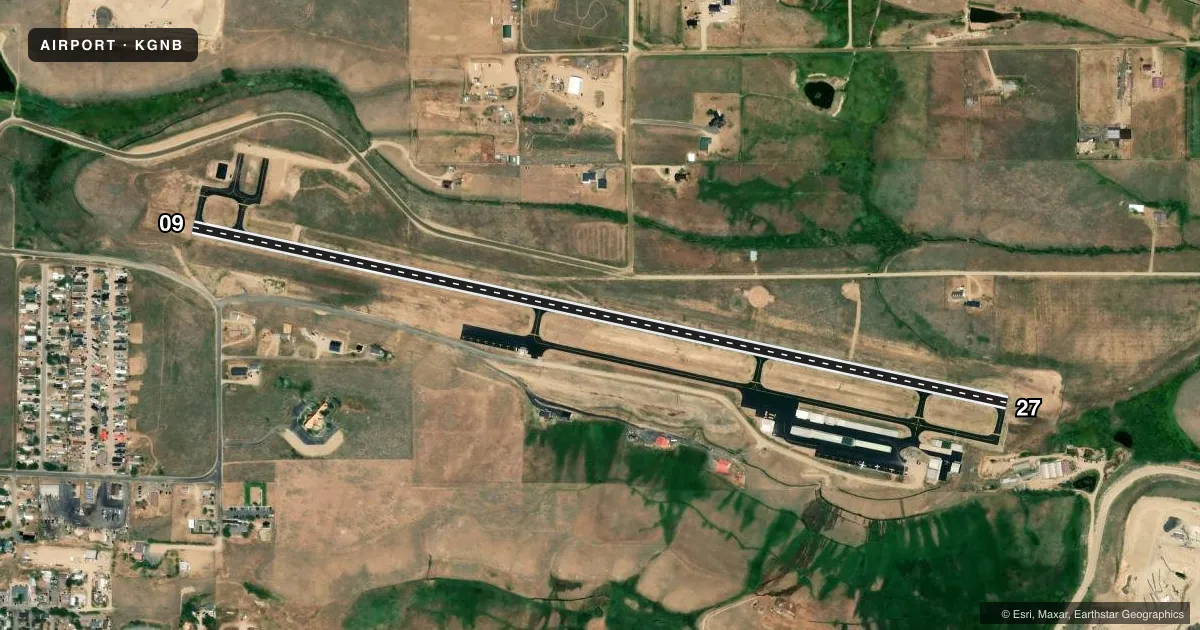
Runways & pattern
Full pagePattern entry · RWY 09
LEFT TRAFFICRunway end performance
| End | TORA | TODA | ASDA | LDA | VGSI | Approach lights | Obstruction |
|---|---|---|---|---|---|---|---|
| 09 | — | — | — | — | PAPI 2-box left(3°) | — | — |
| 27 | — | — | — | — | — | — | 16', fence, 325' from thr, 128' R of cntrln, slope 7 |
Declared distances in feet. TORA = takeoff run available, TODA = takeoff distance, ASDA = accelerate-stop, LDA = landing distance.
Airport sketch
Runways drawn to scale from FAA survey coordinates, rendered over satellite imagery. Not for navigation.
Approaches & charts
Services on the field
Fuel grades, oxygen, maintenance, ramp storage and lighting — as declared to the FAA by the airport operator.
Fuel & services
- Fuel
- 100LLA
- Oxygen (bottled)
- Not available
- Oxygen (bulk)
- Not available
- Airframe repair
- Not available
- Power plant repair
- Not available
- Other services
- INSTR
Ramp & ground
- Transient storage
- Tie-down
- Landing fee
- No fee published
- Customs
- Not available
- Lighting schedule
- SEE RMK
- Beacon schedule
- SS-SR
- Beacon
- White / Green (civil land)(WG)
- Wind indicator
- Lighted
- Segmented circle
- Yes
Fuel & FBOs
Cheapest 100LL and Jet A on the field and nearby. Always confirm with the FBO before taxi.
Airport notes
Surface conditions, obstructions, local procedures, lighting outages and other notes published with each FAA cycle.
General notes
- RCMD TKOF TO EAST ONLY BY EXPERIENCED PILOTS; HIGH GROUND RISES QUICKLY TO THE EAST.
- RWY 27 HAS +525 FT TERRAIN 6000 FT FM THLD 1400 LEFT OF CNTRLN, +52 FT TERRAIN 1200 FT FM THLD ON EXTNDD CNTRLN, +40 FT POWERLINE 965 FT FM THLD 260 LEFT OF CNTRLN.
- FOR CD CTC DENVER ARTCC AT 303-651-4257.
- RWY 09 HAS +563 FT TERRAIN 21277 FT FM THLD 371 FT LEFT OF CNTRLN.
- COLD TEMPERATURE AIRPORT. ALTITUDE CORRECTION REQUIRED AT OR BELOW -24C.
Lighting notes
- ACTVT REIL RWY 09 & 27; LIRL RWY 09/27 - CTAF.
Fuel notes
- 100LLFUEL AVBL 24 HR SELF SVC.
Other notes
- ESTABLISHED PRIOR TO 1959.
- MANAGERARPT CONTACT; JOSHUA SCHROEDER - JSCHROEDER@CO.GRAND.CO.US, 970-887-2123.
VFR map & nearby airports
VFR sectional. Tap any ICAO chip to open that airport.
Key facts · KGNB
Answer card- ICAO
- KGNB
- Name
- GRANBY-GRAND COUNTY
- Location
- GRANBY, COLORADO
- Elevation
- 8,207.1 ft MSL
- Traffic pattern altitude
- 9,207.1 ft MSL (1,000 AGL)
- Control tower
- Non-towered (use CTAF)
- Total runways
- 1
- Longest runway
- 09/27 · 5,001 ft
- Published ILS approaches
- 0
- Published frequencies
- 2
- Magnetic variation
- 8°
- Current flight rules
- VFR
- Current wind
- 040° at 4 kt
- Favored runway now
- RWY 09
Granby-Grand County Airport is in Granby, Colorado. Field elevation is 8,207.1 ft MSL. The airport has one runway. Runway 09/27 is 5,001 ft long with asphalt pavement. There is no control tower. CTAF and UNICOM are both 123.0. No ILS approaches are published.
Pattern altitude is not published. Use 1,000 ft AGL for light piston traffic unless the current Chart Supplement says otherwise. The field sits in high terrain. Performance planning matters. Takeoff to the east is recommended only by experienced pilots because the ground rises quickly that way. Runway 27 also has terrain and a powerline near the departure path. Runway 09 has rising terrain far out on the extended centerline. This is a cold temperature airport. Altitude correction is required at or below minus 24 degrees Celsius.
Granby-Grand County Airport on the field carries 100LL and Jet A Prist. Fuel is available 24 hours by self service. Runway end identifier lights are installed on both ends. Low intensity runway lights are available on 09 and 27. They are controlled by CTAF. For clearance delivery, contact Denver ARTCC. If you are new to the airport, plan conservatively for density altitude, terrain and winter temperature corrections before you launch.