METAR & TAF KGGP
Current METAR
Observed 06:41Z
KGGP 120641Z AUTO 24009KT 10SM SCT010 OVC017 21/19 A2985 RMK AO2
- Wind
- 240° @ 9 kt
- Visibility
- 10 SM
- Temp / Dew
- 21°C / 19°C
- Altimeter
- 29.85 inHg
- Clouds
- OVC
- Density alt
- 1,722 ft
- Ceiling
- 1,700 ft AGL
- Rules
- MVFR
Airport info & contacts
Manager on record, flight service, ARTCC, attendance schedule and pattern altitude — published by the FAA and refreshed every 28 days.
Location
- From city
- 2 NM S
- VFR sectional
- CHICAGO
- ARTCC
- ZAU · CHICAGO
- NOTAM facility
- HUF (NOTAM-D)
Airport manager
- Name
- CHAD WEISEND
- Phone
- (574) 753-4300
- Address
- 3735 S. AIRPORT RD, LOGANSPORT IN 46947
Flight service · Hours
- FSS HUF
- TERRE HAUTE1-800-WX-BRIEF
- Attendance
- 0800-1800
Frequencies
Tap any row to copy the frequency to your clipboard.
Runways & pattern
Full pagePattern entry · RWY 27
LEFT TRAFFICRunway end performance
| End | TORA | TODA | ASDA | LDA | VGSI | Approach lights | Obstruction |
|---|---|---|---|---|---|---|---|
| 09 | 5,001' | 5,001' | 5,001' | 5,001' | PAPI 2-box left(3°) | — | — |
| 27 | 5,001' | 5,001' | 5,001' | 5,001' | PAPI 2-box left(3°) | — | — |
Declared distances in feet. TORA = takeoff run available, TODA = takeoff distance, ASDA = accelerate-stop, LDA = landing distance.
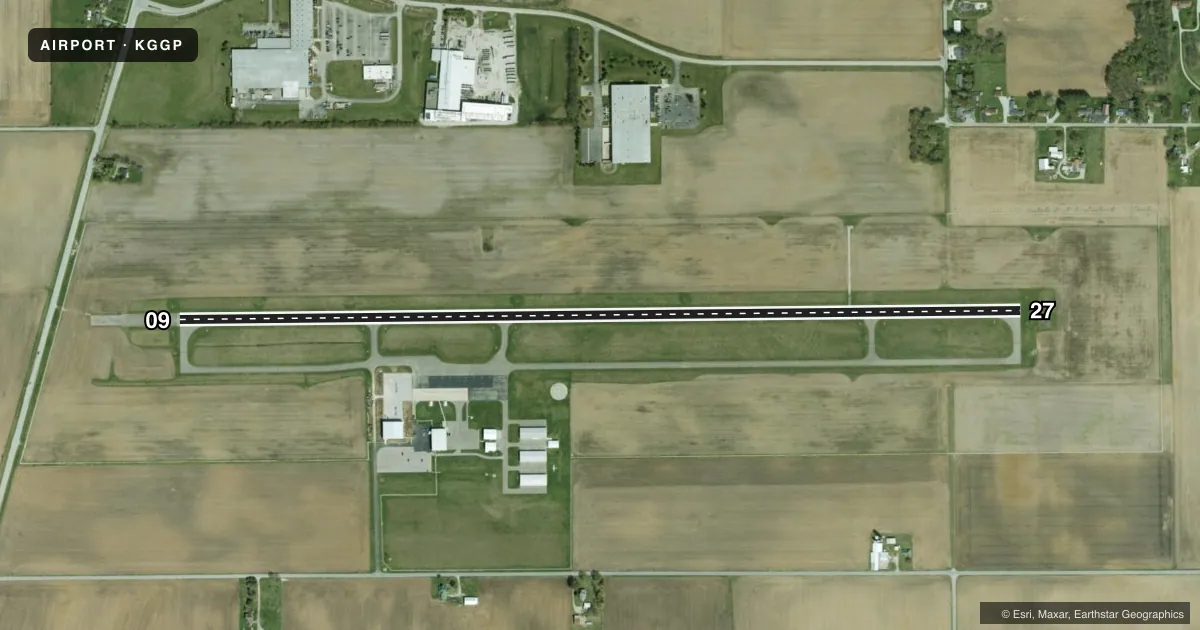
Airport sketch
Runways drawn to scale from FAA survey coordinates, rendered over satellite imagery. Not for navigation.
Approaches & charts
Services on the field
Fuel grades, oxygen, maintenance, ramp storage and lighting — as declared to the FAA by the airport operator.
Fuel & services
- Fuel
- 100LLA
- Oxygen (bottled)
- Not available
- Oxygen (bulk)
- Not available
- Airframe repair
- Major
- Power plant repair
- Major
- Other services
- AFRT,AGRI,CARGO,CHTR,INSTR,RNTL
Ramp & ground
- Transient storage
- Tie-down
- Hangar
- Landing fee
- No fee published
- Customs
- Not available
- Lighting schedule
- SEE RMK
- Beacon schedule
- SS-SR
- Beacon
- White / Green (civil land)(WG)
- Wind indicator
- Lighted
- Segmented circle
- Yes
Fuel & FBOs
Cheapest 100LL and Jet A on the field and nearby. Always confirm with the FBO before taxi.
Airport notes
Surface conditions, obstructions, local procedures, lighting outages and other notes published with each FAA cycle.
General notes
- LANDFILL 1.5 NM NE OF ARPT.
- FOR CD CTC CHICAGO ARTCC AT 630-906-8921.
Lighting notes
- ACTVT REIL RWY 09 & 27; PAPI RWY 09 & 27; MIRL RWY 09/27 - CTAF. MIRL RWY 09/27 PRESET LOW INTST; INCR INTST - CTAF.
Fuel notes
- 100LLSELF SVC WITH CREDIT CARD.
VFR map & nearby airports
VFR sectional. Tap any ICAO chip to open that airport.
Key facts · KGGP
Answer card- ICAO
- KGGP
- Name
- LOGANSPORT/CASS COUNTY
- Location
- LOGANSPORT, INDIANA
- Elevation
- 738.4 ft MSL
- Traffic pattern altitude
- 1,738.4 ft MSL (1,000 AGL)
- Control tower
- Non-towered (use CTAF)
- Total runways
- 1
- Longest runway
- 09/27 · 5,001 ft
- Published ILS approaches
- 0
- Published frequencies
- 4
- Magnetic variation
- 4°
- Current flight rules
- MVFR
- Current wind
- 240° at 9 kt
- Favored runway now
- RWY 27
Logansport/Cass County Airport sits in Logansport, Indiana. Field elevation is 738.4 ft MSL. The airport has one runway, 09/27 and it is 5,001 ft long. There is no control tower. No ILS approaches are published here, so plan with the current Chart Supplement and your own approach setup.
Pattern altitude is not published. Use 1,000 ft AGL for light piston traffic unless current local guidance says otherwise. The field is served by Logansport/Cass County Airport on the field. It carries 100LL and Jet A Prist. Self-serve 100LL is available with credit card. Runway end identifier lights are installed on 09 and 27. PAPI is installed on both ends. Medium intensity runway lights are on 09/27 and are controlled by CTAF. They start at low intensity. Use CTAF to increase them.
For IFR work, clearance delivery is handled through Chicago ARTCC at 630-906-8921. There is also a landfill 1.5 NM northeast of the airport. Keep that in mind on arrival and departure. The airport is non-towered, so expect normal self-announce traffic on CTAF 122.8. Check the current Chart Supplement for any published noise or curfew restrictions before flying into the field.