METAR & TAF KFSD
Current METAR
Observed 17:56Z
KFSD 121756Z 23010G17KT 10SM FEW070 SCT250 26/08 A2992 RMK AO2 SLP127 T02610083 10261 20144 58014
- Wind
- 230° @ 10G17 kt
- Visibility
- 10 SM
- Temp / Dew
- 26°C / 8°C
- Altimeter
- 29.92 inHg
- Clouds
- SCT
- Density alt
- 3,093 ft
- Ceiling
- Unlimited
- Rules
- VFR
Airport info & contacts
Manager on record, flight service, ARTCC, attendance schedule and pattern altitude — published by the FAA and refreshed every 28 days.
Location
- From city
- 3 NM NW
- VFR sectional
- OMAHA
- ARTCC
- ZMP · MINNEAPOLIS
- NOTAM facility
- FSD (NOTAM-D)
Airport manager
- Name
- DANIEL J. LETELLIER
- Phone
- 605-336-0762
- Address
- 2801 JAYCEE LANE, SIOUX FALLS SD 57104
Flight service · Hours
- FSS HON
- HURON1-800-WX-BRIEF
- Attendance
- ALL
Frequencies
Tap any row to copy the frequency to your clipboard.
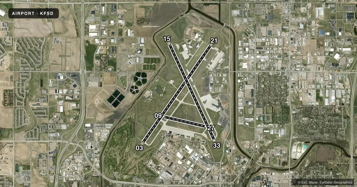
Runways & pattern
Full pagePattern entry · RWY 21
LEFT TRAFFIC| Runway | Heading (°M) | Length | Surface | Traffic |
|---|---|---|---|---|
| 03/21Favored | 30° / 210° | 9,000 ft | CONC | Standard L |
| 15/33 | 150° / 330° | 8,000 ft | CONC | Standard L |
| 09/27 | 98° / 278° | 3,151 ft | CONC | Standard L |
Runway end performance
| End | TORA | TODA | ASDA | LDA | VGSI | Approach lights | Obstruction |
|---|---|---|---|---|---|---|---|
| 03 | 8,999' | 8,999' | 8,999' | 8,999' | PAPI 4-box left(3°) | MALSR | 8', road, 283' from thr, 511' R of cntrln, slope 10 |
| 21 | 8,999' | 8,999' | 8,999' | 8,999' | PAPI 4-box left(3°) | MALSR | 27', rr, 1178' from thr, 645' R of cntrln, slope 35 |
| 15 | 8,000' | 8,000' | 8,000' | 8,000' | PAPI 4-box left(3°) | — | 109', tree, 3786' from thr, 702' R of cntrln, slope 33 |
| 33 | 8,000' | 8,000' | 8,000' | 8,000' | PAPI 4-box left(3°) | — | 47', tree, 1455' from thr, 327' R of cntrln, slope 26 |
| 09 | — | — | — | — | — | — | 71', tree, 2550' from thr, 376' R of cntrln, slope 33 |
| 27 | — | — | — | — | — | — | 149', pole, 4620' from thr, 461' R of cntrln, slope 29 |
Declared distances in feet. TORA = takeoff run available, TODA = takeoff distance, ASDA = accelerate-stop, LDA = landing distance.
Airport sketch
Runways drawn to scale from FAA survey coordinates, rendered over satellite imagery. Not for navigation.
Approaches & charts
ILS · 2
Services on the field
Fuel grades, oxygen, maintenance, ramp storage and lighting — as declared to the FAA by the airport operator.
Fuel & services
- Fuel
- 100LLA
- Oxygen (bottled)
- High pressure
- Oxygen (bulk)
- High pressure
- Airframe repair
- Major
- Power plant repair
- Major
- Other services
- AFRT,AMB,AVNCS,CHTR,INSTR,RNTL,SALES,SURV
Ramp & ground
- Transient storage
- Tie-down
- Hangar
- Landing fee
- No fee published
- Customs
- Not available
- Lighting schedule
- SEE RMK
- Beacon schedule
- SS-SR
- Beacon
- White / Green (civil land)(WG)
- Wind indicator
- Lighted
- Segmented circle
- Yes
Fuel & FBOs
Cheapest 100LL and Jet A on the field and nearby. Always confirm with the FBO before taxi.
Airport notes
Surface conditions, obstructions, local procedures, lighting outages and other notes published with each FAA cycle.
General notes
- MIGRATORY BIRDS WITHIN 25 NM PRIMARILY BETWEEN MAR-NOV.
- WATERFOWL, BIRDS & DEER ON & INVOF ARPT.
- FLT NOTIFICATION SVC (ADCUS) AVBL MON-FRI 0800-1600 CALL (605) 338-4384; AFT HRS CALL (605) 373-3523 PRIOR TO DEP.
- EAST GA RAMP RESTRICTED TO 60,000 LBS.
- ATCT HAS LIMITED VIS ON TWYS HOTEL, GOLF AND JULIET BTN THE EAST CARGO RAMP AND TWY BRAVO.
- BE ALERT: MARV SKIE-LINCOLN COUNTY AIRPORT (Y14) LOCATED 7.2 MILES SW OF FSD & 2 MILES EAST OF ROKKY HAS HEAVY VFR TRAFFIC.
- ANG: NUMEROUS NSTD MRK ON THE ANG PRK APRON. COMSEC STORAGE UNAVBL.BASH PHASE II OPS EFF MAR-APR, SEP-OCT; EXP INCR BIRD ACT; CTC ANG BASE OPS.
- MILITARY: SVC: FUEL: A++, A++100 CTC ANG DSN 798-7754, C605-988-5754.
- TWY C CLSD EXCEPT MIL ACFT.
- SFC CONDS NOT MONITORED 0000-0430 HRS LCL.
- TWY C CLSD EXCEPT MIL ACFT.
- RWY 15/33 AND 3/21 A-GEAR NOT NMLLY UP. RQR 30 MIN PN, ONLY AVBL DRG NML ANG DUTY HR (OCT - APR).
- FOR CD WHEN ATCT CLSD, CTC FSS. IF UNA, CTC MINNEAPOLIS ARTCC AT 651-463-5588.
- COLD TEMPERATURE AIRPORT. ALTITUDE CORRECTION REQUIRED AT OR BELOW -30C.
- ANG: BASE OPS DSN 798-7754/7746, C605-988-5754/5746. LOBO OPS/MAINT 138.25 253.4. FOR RCR CALL BASE OPS.
Lighting notes
- ACTVT MALSR RWY 03 & 21; REIL RWY 15 & 33; HIRL RWY 03/21 & 15/33; MIRL RWY 9/27. WHEN ATCT CLSD MALSR RWY 03 & 21 PRESET ON LOW INTST, TO INCR INTST - CTAF. PAPI RWY 03, 21, 15, 33 OPR CONSLY.
Runway surface & condition
- 03/21PCR VALUE: 960/R/D/W/T
- 15/33PCR VALUE: 780/R/D/W/T
- 09/27RWY 09/27 NOT AVBL FOR PART 121/PART 380 OPS WITH SKED PAX CARRYING OPS MORE THAN 9 PAX SEATS AND NON-SKED PAX CARRYING OPS MORE THAN 30 PAX SEATS. NO PART 121/PART 380 OPS EXC FOR TAX.
Approach & departure obstructions
- 15PAPI UNUSBL BYD 6 DEGS LEFT AND 5 DEGS RIGHT OF CNTRLN.
- 33PAPI UNUSBL BYD 9 DEGS RIGHT OF CNTRLN.
- 15ALSO LGTD TWR; 4962 FM RY END; 159 ABV RY END; 893 R OF CNTRLN; 29:1 SLOPE.
Arresting gear
- 03_BAK-12BAK-14 BAK-12B(B) (1540').
- 15_BAK-12BAK-14 BAK-12B(B) (1550').
- 21_BAK-12BAK-14 BAK-12B(B) (1500').
- 33_BAK-12BAK-14 BAK-12B(B) (1500').
VFR map & nearby airports
VFR sectional. Tap any ICAO chip to open that airport.
Key facts · KFSD
Answer card- ICAO
- KFSD
- Name
- JOE FOSS FLD
- Location
- SIOUX FALLS, SOUTH DAKOTA
- Elevation
- 1,430 ft MSL
- Traffic pattern altitude
- 2,430 ft MSL (1,000 AGL)
- Control tower
- Towered · 0500-0000
- Total runways
- 3
- Longest runway
- 03/21 · 9,000 ft
- Published ILS approaches
- 2
- Published frequencies
- 14
- Magnetic variation
- 5°
- Current flight rules
- VFR
- Current wind
- 230° at 10 kt
- Favored runway now
- RWY 21
Joe Foss Fld sits in Sioux Falls, South Dakota. Field elevation is 1,430 ft MSL. The airport has three concrete runways. The longest is 9,000 ft on 03/21. The tower is open from 0500 to 0000. Two ILS approaches are published for runway ends 03 and 21.
Pattern altitude is not published in the facts. Use standard traffic pattern altitude for light piston aircraft unless ATC or the current Chart Supplement says otherwise. On-field FBOs are Signature Aviation and Maverick Air Center. Both carry 100LL and Jet A. That makes fuel planning straightforward for piston and turbine traffic.
A few operational items matter here. Runway 03 and 21 have MALSR lighting. Runway 15/33 has REIL and high-intensity lights. Runway 9/27 has medium-intensity lights. When the tower is closed, the MALSR on 03 and 21 comes up at low intensity. Use CTAF to raise it. The field is also a cold temperature airport. Altitude correction is required at or below minus 30 degrees Celsius. Expect busy local traffic. MARV SKIE-Lincoln County Airport is nearby. The remarks call out heavy VFR traffic in that area. Wildlife is also listed. Plan for birds and deer on or near the airport.