METAR & TAF KFHR
Current METAR
Observed 18:06Z
KFHR 271806Z AUTO 16006KT 10SM OVC015 17/13 A3007 RMK AO2 T01670133
- Wind
- 160° @ 6 kt
- Visibility
- 10 SM
- Temp / Dew
- 17°C / 13°C
- Altimeter
- 30.07 inHg
- Clouds
- OVC
- Density alt
- 194 ft
- Ceiling
- 1,500 ft AGL
- Rules
- MVFR
Airport info & contacts
Manager on record, flight service, ARTCC, attendance schedule and pattern altitude — published by the FAA and refreshed every 28 days.
Location
- From city
- 0 NM SW
- VFR sectional
- SEATTLE
- ARTCC
- ZSE · SEATTLE
- NOTAM facility
- FHR (NOTAM-D)
Airport manager
- Name
- MIKE OTIS
- Phone
- (360) 378-4724
- Address
- PO BOX 889, FRIDAY HARBOR WA 98250
Flight service · Hours
- FSS SEA
- SEATTLE1-800-WX-BRIEF
- Attendance
- MON-FRI · 0800-1700
Frequencies
Tap any row to copy the frequency to your clipboard.
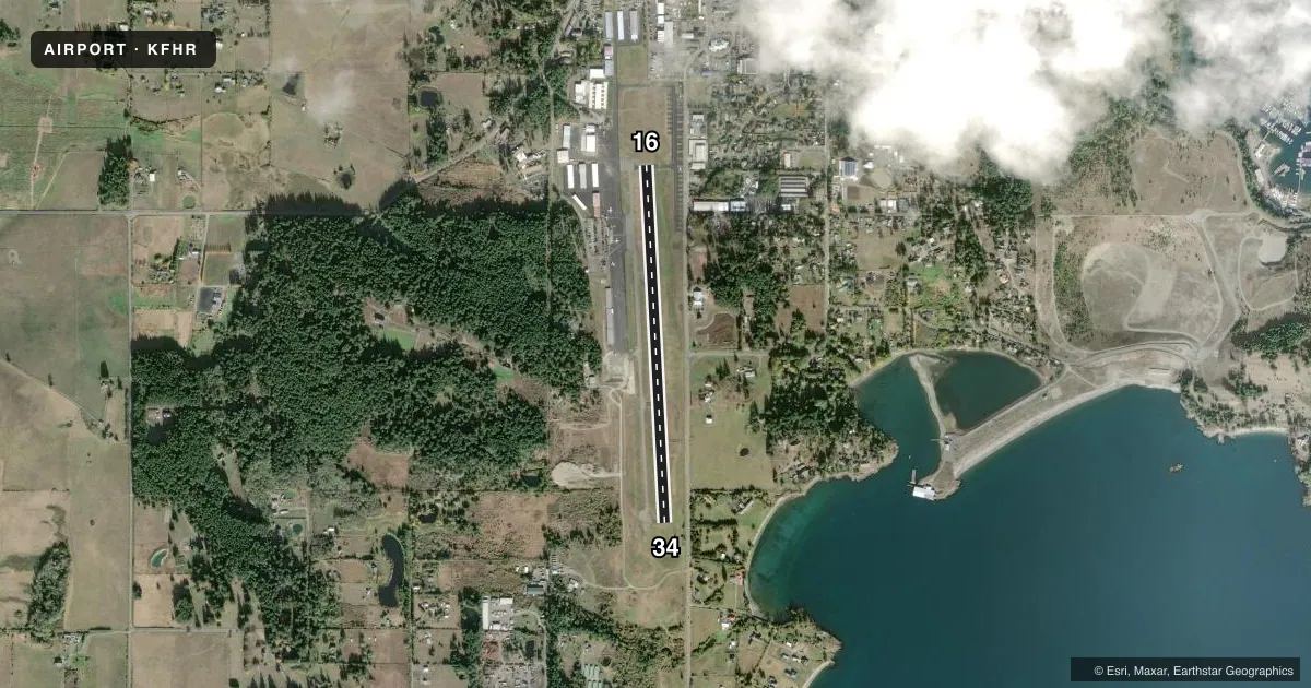
Runways & pattern
Full pagePattern entry · RWY 16
RIGHT TRAFFICRunway end performance
| End | TORA | TODA | ASDA | LDA | VGSI | Approach lights | Obstruction |
|---|---|---|---|---|---|---|---|
| 16 | — | — | — | — | PAPI 2-box right(4°) | — | 32', bldg, 904' from thr, 126' R of cntrln, slope 22 |
| 34 | — | — | — | — | PAPI 4-box right(3.5°) | — | 70', trees, 2650' from thr, 0' R of cntrln, slope 34 |
Declared distances in feet. TORA = takeoff run available, TODA = takeoff distance, ASDA = accelerate-stop, LDA = landing distance.
Airport sketch
Runways drawn to scale from FAA survey coordinates, rendered over satellite imagery. Not for navigation.
Approaches & charts
Services on the field
Fuel grades, oxygen, maintenance, ramp storage and lighting — as declared to the FAA by the airport operator.
Fuel & services
- Fuel
- 100LL
- Oxygen (bottled)
- Not available
- Oxygen (bulk)
- Not available
- Airframe repair
- Major
- Power plant repair
- Major
- Other services
- AFRT,AMB,CARGO,CHTR,INSTR,RNTL
Ramp & ground
- Transient storage
- Tie-down
- Landing fee
- Yes
- Customs
- Available
- Lighting schedule
- SEE RMK
- Beacon schedule
- SS-SR
- Beacon
- White / Green (civil land)(WG)
- Wind indicator
- Lighted
- Segmented circle
- Yes
Fuel & FBOs
Cheapest 100LL and Jet A on the field and nearby. Always confirm with the FBO before taxi.
Airport notes
Surface conditions, obstructions, local procedures, lighting outages and other notes published with each FAA cycle.
General notes
- NOISE ABATEMENT PROCS IN EFFECT CTC AMGR 360-378-4724.
- SOFT GROUND BETWEEN TIE-DOWNS NE PARKING AREA.
- PREFERRED RY 16 IN CALM WIND CONDITIONS.
- DUE TO HIGH CONCENTRATION OF TFC INVOF ARPT RECOMMEND LDG LGTS OR FORWARD VISIBILITY LGTS TURNED ON WHILE UTILIZING ARPT.
- ACFT WITH WINGSPAN GREATER THAN 55 FT, 24 HR PPR. CTC ARPT MGR 360-378-4724 OR CELL 360-317-8674.
- 128.25 MONITORED INTMTLY.
- BIRD ACTIVITY ON AND INVOF ARPT.
- CUSTOMS APRON LOCATED ON EAST SIDE OF TERMINAL RAMP.
- FOR CD CTC WHIDBEY APCH AT 360-257-3310.
- TSNT TURBINE ACFT PRKG LESS THAN 1 HR DURN LCTD 250 FT S OF TRML RAMP.
- FOR NOISE ABATEMENT AVOID TKOFS BTN 2200-0700.
Lighting notes
- ACTVT REIL RWY 16 & 34; PAPI RWY 16 & 34; MIRL RWY 16/34 - CTAF.
Approach & departure obstructions
- 16PAPI UNUSBL BYD 3 DEGS RIGHT OF CNTRLN
Other notes
- THIS AIRPORT HAS BEEN SURVEYED BY THE NATIONAL GEODETIC SURVEY.
- ESTABD PRIOR TO 5/15/59.
- LNDG FEES CHARGED FOR AIRLINES AND CHARTERS.
- ACFT IN EXCESS OF 7,500 LBS CHARGED FEE BASED ON WEIGHT - CTC ARPT MGR FOR INFO.
- PILOTS BRING OWN TIE-DOWN ROPES.
- 1NO ATTENDANCE DURING HOLIDAYS.
- MANAGERCELL:360-317-8674
VFR map & nearby airports
VFR sectional. Tap any ICAO chip to open that airport.
Key facts · KFHR
Answer card- ICAO
- KFHR
- Name
- FRIDAY HARBOR
- Location
- FRIDAY HARBOR, WASHINGTON
- Elevation
- 112.7 ft MSL
- Traffic pattern altitude
- 1,112.7 ft MSL (1,000 AGL)
- Control tower
- Non-towered (use CTAF)
- Total runways
- 1
- Longest runway
- 16/34 · 3,402 ft
- Published ILS approaches
- 0
- Published frequencies
- 3
- Magnetic variation
- 16°
- Current flight rules
- MVFR
- Current wind
- 160° at 6 kt
- Favored runway now
- RWY 16
Friday Harbor Airport (KFHR) sits in Friday Harbor, Washington. Field elevation is 112.7 ft MSL. The airport has one runway. Runway 16/34 is 3,402 ft long with asphalt pavement. There is no control tower. Traffic works CTAF 128.25. Whidbey Approach handles departure and approach services on 118.2 and 285.65.
No ILS approaches are published here. The published pattern altitude is not listed, so use the standard 1,000 ft AGL for light piston operations unless the current FAA Chart Supplement says otherwise. The runway lighting and REIL are activated on CTAF. PAPI is also published for both ends. That helps for night work or a first visit.
Sound Aircraft Maintenance is on the field. It carries AVGAS 100LL. Pilots should plan for a busy local traffic environment. The published remarks call out high traffic near the airport, so lights on during arrival and departure is a good habit. Noise abatement procedures are in effect. Check the current FAA Chart Supplement and contact the airport manager before arrival if you need the current details. Aircraft over 7,500 lb may be charged a fee based on weight. Wingspans over 55 ft need 24-hour prior permission. There is also soft ground near the tie-down area, so use care when parking.