METAR & TAF KEWB
Current METAR
Observed 04:53Z
KEWB 120453Z AUTO 20003KT 10SM CLR 21/20 A2969 RMK AO2 SLP052 T02110200 403110172
- Wind
- 200° @ 3 kt
- Visibility
- 10 SM
- Temp / Dew
- 21°C / 20°C
- Altimeter
- 29.69 inHg
- Clouds
- CLR
- Density alt
- 1,103 ft
- Ceiling
- Unlimited
- Rules
- VFR
Airport info & contacts
Manager on record, flight service, ARTCC, attendance schedule and pattern altitude — published by the FAA and refreshed every 28 days.
Location
- From city
- 2 NM NW
- VFR sectional
- NEW YORK
- ARTCC
- ZBW · BOSTON
- NOTAM facility
- EWB (NOTAM-D)
Airport manager
- Name
- SCOT SERVIS
- Phone
- 508-991-6161
- Address
- 1569 AIRPORT RD, NEW BEDFORD MA 02746
Flight service · Hours
- FSS BDR
- BRIDGEPORT1-800-WX-BRIEF
- Attendance
- 0600-2300
Frequencies
Tap any row to copy the frequency to your clipboard.
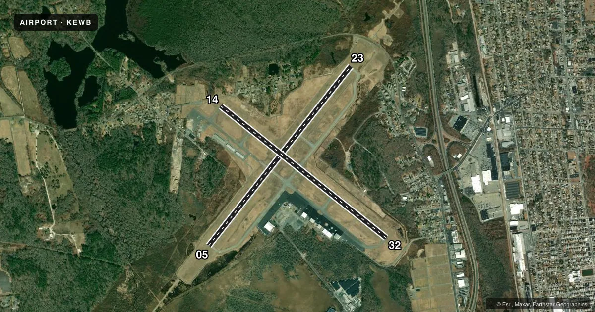
Runways & pattern
Full pagePattern entry · RWY 23
LEFT TRAFFIC| Runway | Heading (°M) | Length | Surface | Traffic |
|---|---|---|---|---|
| 05/23Favored | 22° / 202° | 5,400 ft | ASPH | Standard L |
| 14/32 | 112° / 292° | 5,002 ft | ASPH | Standard L |
Runway end performance
| End | TORA | TODA | ASDA | LDA | VGSI | Approach lights | Obstruction |
|---|---|---|---|---|---|---|---|
| 05 | — | — | — | — | — | MALSR | 20', tree, 1200' from thr, slope 50 |
| 23 | — | — | — | — | PAPI 4-box left(3°) | MALSR | 35', tree, 1400' from thr, 125' R of cntrln, slope 34 |
| 14 | — | — | — | — | PAPI 4-box left(3.42°) | — | 10', tree, 400' from thr, 0' R of cntrln, slope 20 |
| 32 | — | — | — | — | PAPI 4-box left(3.5°) | — | 11', trees, 600' from thr, 130' R of cntrln, slope 36 |
Declared distances in feet. TORA = takeoff run available, TODA = takeoff distance, ASDA = accelerate-stop, LDA = landing distance.
Airport sketch
Runways drawn to scale from FAA survey coordinates, rendered over satellite imagery. Not for navigation.
Approaches & charts
ILS · 1
Services on the field
Fuel grades, oxygen, maintenance, ramp storage and lighting — as declared to the FAA by the airport operator.
Fuel & services
- Fuel
- 100LLA
- Oxygen (bottled)
- HIGH/LOW
- Airframe repair
- Major
- Power plant repair
- Major
- Other services
- AFRT,CHTR,INSTR,RNTL,SALES
Ramp & ground
- Transient storage
- Tie-down
- Hangar
- Landing fee
- No fee published
- Customs
- Not available
- Lighting schedule
- SEE RMK
- Beacon schedule
- SS-SR
- Beacon
- White / Green (civil land)(WG)
- Wind indicator
- Yes
- Segmented circle
- No
Fuel & FBOs
Cheapest 100LL and Jet A on the field and nearby. Always confirm with the FBO before taxi.
Airport notes
Surface conditions, obstructions, local procedures, lighting outages and other notes published with each FAA cycle.
General notes
- BIRDS & WILDLIFE ON & INVOF ARPT.
- LDG FEES FOR ACFT OVR 3000 LBS.
- FOR CD WHEN APCH CLSD CTC BOSTON ARTCC AT 603-879-6859.
- TWYS A1 & A2 FOR ACR ACFT ONLY.
Lighting notes
- WHEN ATCT CLSD ACTVT MALSR RWYS 05 & 23; REIL RWY 32; HIRL RWY 05/23; MIRL RWY 14/32 - CTAF. PAPI RWYS 14, 23 & 32 OPR 24 HRS.
Runway surface & condition
- 05/23PCR VALUE: 810/F/A/X/T
- 14/32PCR VALUE: 930/F/A/X/T
- 05/23RWY 05/23 NOT AVBL FOR PART 121/PART 380 OPS WITH SKED PAX CARRYING OPS MORE THAN 9 PAX SEATS AND NON-SKED PAX CARRYING OPS MORE THAN 30 PAX SEATS. 90 DAY PPR FOR UNSKED ACR OPS GTR THAN 30 PAX SEATS - CALL AMGR.
- 14/32RWY 14/32 NOT AVBL FOR PART 121/PART 380 OPS WITH SKED PAX CARRYING OPS MORE THAN 9 PAX SEATS AND NON-SKED PAX CARRYING OPS MORE THAN 30 PAX SEATS. 90 DAY PPR FOR UNSKED ACR OPS GTR THAN 30 PAX SEATS - CALL AMGR.
Approach & departure obstructions
- 23APCH SLP 50:1 AT DTHR.
Other notes
- PRVDD APCH/DEP SFCS CONFORM WITH TERPS & FAR PART 77.
VFR map & nearby airports
VFR sectional. Tap any ICAO chip to open that airport.
Key facts · KEWB
Answer card- ICAO
- KEWB
- Name
- NEW BEDFORD RGNL
- Location
- NEW BEDFORD, MASSACHUSETTS
- Elevation
- 79.1 ft MSL
- Traffic pattern altitude
- 1,079.1 ft MSL (1,000 AGL)
- Control tower
- Towered · 0630-2200
- Total runways
- 2
- Longest runway
- 05/23 · 5,400 ft
- Published ILS approaches
- 1
- Published frequencies
- 10
- Magnetic variation
- 16°
- Current flight rules
- VFR
- Current wind
- 200° at 3 kt
- Favored runway now
- RWY 23
New Bedford Rgnl sits in New Bedford, Massachusetts. Field elevation is 79.1 ft MSL. The airport has two asphalt runways. The longest is 5,400 ft on runway 05/23. The tower is open daily from 0630 to 2200. Runway 05 has the field's ILS approach. Pattern altitude is not published. Use 1,000 ft AGL for light piston traffic unless ATC or the current Chart Supplement says otherwise.
This is a busy coastal field with published bird and wildlife activity in and around the airport. That matters on departure and on short final. Runway 05/23 is not available for certain Part 121 and Part 380 passenger operations. Runway 14/32 has the same restriction. Landing fees apply to aircraft over 3,000 lb. Taxiways A1 and A2 are for aircraft rescue only. When the tower is closed, runway lighting is activated on CTAF. The PAPI on runways 14, 23 and 32 operates 24 hours.
Colonial Air and Nor East Aviation Services are on the field. Both carry 100LL, Jet A and Jet A Prist. If you are planning a larger aircraft or an unusual operation, call the airport manager before you go. The published remarks also note a 50:1 approach slope issue near the displaced threshold of runway 23. Check the current FAA Chart Supplement for any local procedures before arrival.