METAR & TAF KDCY
Current METAR
Observed 10:35Z
KDCY 121035Z AUTO 00000KT 10SM VCTS BKN055 OVC090 21/21 A2994 RMK AO2 LTG DSNT SE AND SW T02110206
- Wind
- 000° @ 0 kt
- Visibility
- 10 SM
- Temp / Dew
- 21°C / 21°C
- Altimeter
- 29.94 inHg
- Clouds
- OVC
- Density alt
- 1,281 ft
- Ceiling
- 5,500 ft AGL
- Rules
- VFR
Airport info & contacts
Manager on record, flight service, ARTCC, attendance schedule and pattern altitude — published by the FAA and refreshed every 28 days.
Location
- From city
- 3 NM NE
- VFR sectional
- ST LOUIS
- ARTCC
- ZID · INDIANAPOLIS
- NOTAM facility
- HUF (NOTAM-D)
Airport manager
- Name
- ERICA BURKEMPER
- Phone
- 812-698-0463
- Address
- 1724 E 250 N, WASHINGTON IN 47501
Flight service · Hours
- FSS HUF
- TERRE HAUTE1-800-WX-BRIEF
- Attendance
- MON-FRI · 0800-1700
Frequencies
Tap any row to copy the frequency to your clipboard.
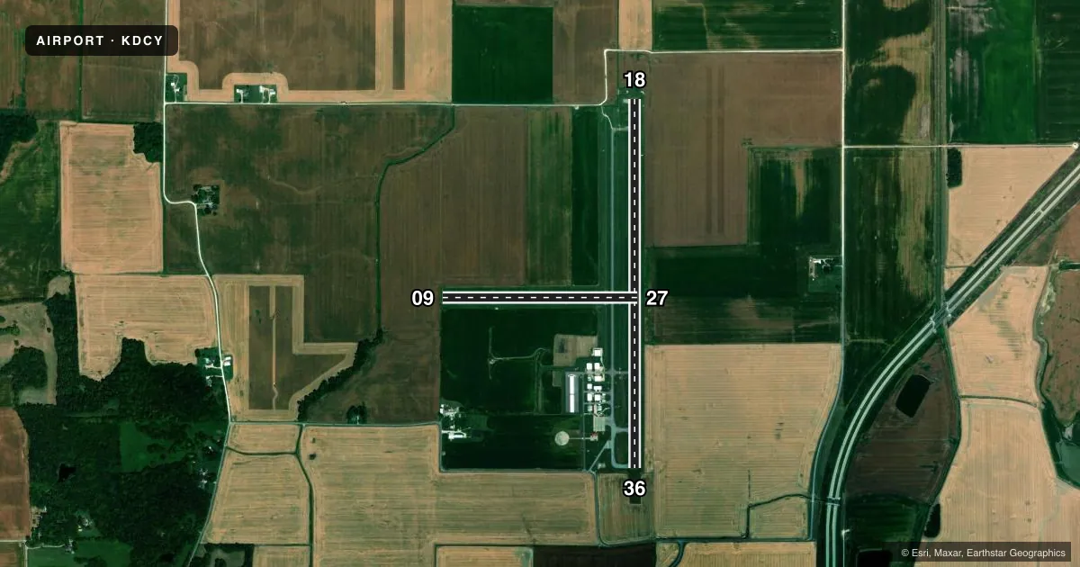
Runways & pattern
Full pagePattern entry · RWY 18
LEFT TRAFFIC| Runway | Heading (°M) | Length | Surface | Traffic |
|---|---|---|---|---|
| 18/36 | 177° / 357° | 5,002 ft | ASPH | Standard L |
| 09/27 | 86° / 268° | 2,651 ft | TURF | Standard L |
Runway end performance
| End | TORA | TODA | ASDA | LDA | VGSI | Approach lights | Obstruction |
|---|---|---|---|---|---|---|---|
| 18 | — | — | — | — | PAPI 2-box left(3°) | — | 10', crops, 300' from thr, 0' R of cntrln, slope 10 |
| 36 | — | — | — | — | PAPI 2-box left(3°) | — | 10', crops, 201' from thr, 0' R of cntrln, slope 0 |
| 09 | — | — | — | — | — | — | 10', crops, 201' from thr, 0' R of cntrln, slope 20 |
Declared distances in feet. TORA = takeoff run available, TODA = takeoff distance, ASDA = accelerate-stop, LDA = landing distance.
Airport sketch
Runways drawn to scale from FAA survey coordinates, rendered over satellite imagery. Not for navigation.
Approaches & charts
Services on the field
Fuel grades, oxygen, maintenance, ramp storage and lighting — as declared to the FAA by the airport operator.
Fuel & services
- Fuel
- 100LLA+
- Oxygen (bottled)
- Low pressure
- Other services
- INSTR,RNTL
Ramp & ground
- Transient storage
- Tie-down
- Hangar
- Landing fee
- No fee published
- Customs
- Not available
- Lighting schedule
- SEE RMK
- Beacon schedule
- SS-SR
- Beacon
- White / Green (civil land)(WG)
- Wind indicator
- Lighted
- Segmented circle
- Yes
Fuel & FBOs
Cheapest 100LL and Jet A on the field and nearby. Always confirm with the FBO before taxi.
Airport notes
Surface conditions, obstructions, local procedures, lighting outages and other notes published with each FAA cycle.
General notes
- FOR CD CTC EVANSVILLE APCH AT 812-436-4690, WHEN APCH CLSD CTC INDIANAPOLIS ARTCC AT 317-247-2411.
- SELF SERVE FUEL AVBL.
Lighting notes
- ACTVT REIL RWY 36; PAPI RWY 18 & 36; MIRL RWY 18/36 - CTAF.
Approach & departure obstructions
- 3610 FT CROPS 70 FT FM RWY END 75 FT L & R.
VFR map & nearby airports
VFR sectional. Tap any ICAO chip to open that airport.
Key facts · KDCY
Answer card- ICAO
- KDCY
- Name
- DAVIESS COUNTY
- Location
- WASHINGTON, INDIANA
- Elevation
- 472.3 ft MSL
- Traffic pattern altitude
- 1,472.3 ft MSL (1,000 AGL)
- Control tower
- Non-towered (use CTAF)
- Total runways
- 2
- Longest runway
- 18/36 · 5,002 ft
- Published ILS approaches
- 0
- Published frequencies
- 4
- Magnetic variation
- 3°
- Current flight rules
- VFR
- Current wind
- 000° at 0 kt
- Favored runway now
- –
Daviess County Airport sits in Washington, Indiana. Field elevation is 472.3 ft MSL. It has two runways. The longest is 18/36 at 5,002 ft. Runway 09/27 is turf at 2,651 ft. There is no control tower. CTAF and UNICOM are both 122.8. Evansville Approach handles 125.6 and 343.7. For clearance delivery, contact Evansville Approach. If approach is closed, use Indianapolis ARTCC.
No ILS approaches are published here. Pattern altitude is not published, so use the standard 1,000 ft AGL for light piston operations unless current guidance says otherwise. The field has one on-field FBO, Daviess County Airport. It carries 100LL and Jet A with Prist. Self-serve fuel is available.
Runway 18/36 has runway end identifier lights, PAPI and medium intensity runway lights controlled by CTAF. That helps for night work on the paved runway. Watch the north end of runway 36. The published remarks call out 10 ft crops about 70 ft from the runway end. Crops are also 75 ft left and right of the threshold area. If you are planning a first stop here, brief the turf runway carefully and expect a small-field feel with a non-towered pattern.