METAR & TAF KCUT
Current METAR
Observed 08:53Z
KCUT 120853Z AUTO 23003KT 10SM CLR 08/01 A3010 RMK AO2 SLP160 T00830011 56004
- Wind
- 230° @ 3 kt
- Visibility
- 10 SM
- Temp / Dew
- 8°C / 1°C
- Altimeter
- 30.10 inHg
- Clouds
- CLR
- Density alt
- 5,905 ft
- Ceiling
- Unlimited
- Rules
- VFR
Airport info & contacts
Manager on record, flight service, ARTCC, attendance schedule and pattern altitude — published by the FAA and refreshed every 28 days.
Location
- From city
- 2 NM SW
- VFR sectional
- CHEYENNE
- ARTCC
- ZDV · DENVER
- NOTAM facility
- CUT (NOTAM-D)
Airport manager
- Name
- BRENDEN HENDRICKSON
- Phone
- 605-673-3874
- Address
- 12220 AVIATION WAY, CUSTER SD 57730
Flight service · Hours
- FSS HON
- HURON1-800-WX-BRIEF
- Attendance
- MON-FRI · 1500-0000
Frequencies
Tap any row to copy the frequency to your clipboard.
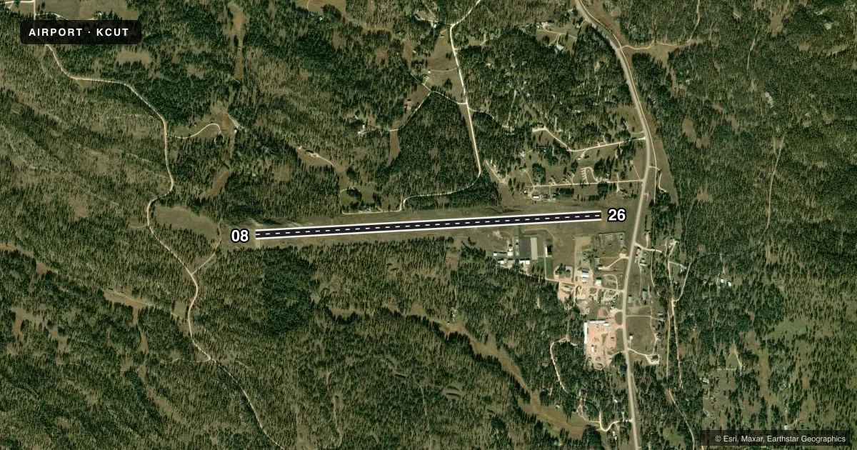
Runways & pattern
Full pagePattern entry · RWY 26
LEFT TRAFFICRunway end performance
| End | TORA | TODA | ASDA | LDA | VGSI | Approach lights | Obstruction |
|---|---|---|---|---|---|---|---|
| 08 | — | — | — | — | PAPI 4-box left(3°) | — | — |
| 26 | — | — | — | — | PAPI 4-box left(3.65°) | — | 60', trees, 1500' from thr, 0' R of cntrln, slope 21 |
Declared distances in feet. TORA = takeoff run available, TODA = takeoff distance, ASDA = accelerate-stop, LDA = landing distance.
Airport sketch
Runways drawn to scale from FAA survey coordinates, rendered over satellite imagery. Not for navigation.
Approaches & charts
Services on the field
Fuel grades, oxygen, maintenance, ramp storage and lighting — as declared to the FAA by the airport operator.
Fuel & services
- Fuel
- 100LLA
- Oxygen (bottled)
- Not available
- Oxygen (bulk)
- Not available
- Airframe repair
- Not available
- Power plant repair
- Not available
- Other services
- AMB,INSTR,RNTL
Ramp & ground
- Transient storage
- Tie-down
- Hangar
- Landing fee
- No fee published
- Customs
- Not available
- Lighting schedule
- SEE RMK
- Beacon schedule
- SS-SR
- Beacon
- White / Green (civil land)(WG)
- Wind indicator
- Lighted
- Segmented circle
- Yes
Fuel & FBOs
Cheapest 100LL and Jet A on the field and nearby. Always confirm with the FBO before taxi.
Airport notes
Surface conditions, obstructions, local procedures, lighting outages and other notes published with each FAA cycle.
General notes
- STRONG CROSSWINDS & WINDSHEAR MAY EXIST ON FINAL UNDER WINDY CONDS.
- CFM WINTER CONDS WITH AMGR 605-858-1246.
- BE ALERT: CHECK DENSITY ALT & LEAN MIXTURE FOR BEST OPERATION AT THIS ALT.
- 10 FT WILDLIFE FENCE AROUND PERIMETER OF AIRPORT.
- FUEL AVBL 24 HR WITH CREDIT CARD.
- FOR CD CTC ELLSWORTH APCH AT 605-385-6198, WHEN APCH CLSD CTC DENVER ARTCC AT 303-651-4257.
- HIGH VOL OF ACFT OPRNG INVOF OF MT RUSHMORE AND CRAZY HORSE MONUMENTS AT OR BLW 7500 FT; PILOTS ARE ADVISED TO MNT 122.85 FOR TFC ADVISORIES.
Lighting notes
- ARPT BCN OBSC RDLS 200-260.
- ACTVT MIRL RWY 08/26; PAPI RWY 08 & 26 - CTAF.
Other notes
- MANAGERMGR CELL NUMBER 605-858-1246.
VFR map & nearby airports
VFR sectional. Tap any ICAO chip to open that airport.
Key facts · KCUT
Answer card- ICAO
- KCUT
- Name
- CUSTER COUNTY
- Location
- CUSTER, SOUTH DAKOTA
- Elevation
- 5,619.7 ft MSL
- Traffic pattern altitude
- 6,619.7 ft MSL (1,000 AGL)
- Control tower
- Non-towered (use CTAF)
- Total runways
- 1
- Longest runway
- 08/26 · 5,500 ft
- Published ILS approaches
- 0
- Published frequencies
- 2
- Magnetic variation
- 11°
- Current flight rules
- VFR
- Current wind
- 230° at 3 kt
- Favored runway now
- RWY 26
Custer County Airport sits in Custer, South Dakota. The field elevation is 5,619.7 ft MSL. It has one runway. Runway 08/26 is 5,500 ft asphalt, which is the longest runway on the field. There is no control tower. CTAF and UNICOM are both 122.8. No ILS approaches are published here.
Pattern altitude is not published. Use the standard 1,000 ft AGL for light piston traffic unless local procedures say otherwise. The airport is at high elevation, so density altitude matters. Lean for best operation before takeoff. Winds can also be a factor here. Published remarks call out strong crosswinds and windshear on final when conditions are windy.
Custer County Airport is the on-field FBO. It carries 100LL and Jet A Prist. Fuel is available 24 hours with credit card. The airport also has a 10-foot wildlife fence around the perimeter. For night work, runway lights are medium intensity on 08/26. PAPI is available on both ends and is controlled by CTAF. First-time visitors should also note the heavy traffic environment near Mount Rushmore and Crazy Horse Monuments. Monitor 122.85 for traffic advisories in that area. Check winter conditions with the airport manager before arrival.