METAR & TAF KBYY
Current METAR
Observed 20:35Z
KBYY 112035Z AUTO 15013KT 10SM FEW025 SCT049 30/28 A2984 RMK AO2 T03040281 $
- Wind
- 150° @ 13 kt
- Visibility
- 10 SM
- Temp / Dew
- 30°C / 28°C
- Altimeter
- 29.84 inHg
- Clouds
- SCT
- Density alt
- 1,955 ft
- Ceiling
- Unlimited
- Rules
- VFR
Airport info & contacts
Manager on record, flight service, ARTCC, attendance schedule and pattern altitude — published by the FAA and refreshed every 28 days.
Location
- From city
- 5 NM E
- VFR sectional
- HOUSTON
- ARTCC
- ZHU · HOUSTON
- NOTAM facility
- BYY (NOTAM-D)
Airport manager
- Name
- JAMES MASON
- Phone
- 979-244-5037
- Address
- 3598 NORTH FM 2540, BAY CITY TX 77414
Flight service · Hours
- FSS CXO
- MONTGOMERY COUNTY1-800-WX-BRIEF
- Attendance
- MON-FRI · 0800-1700
Frequencies
Tap any row to copy the frequency to your clipboard.
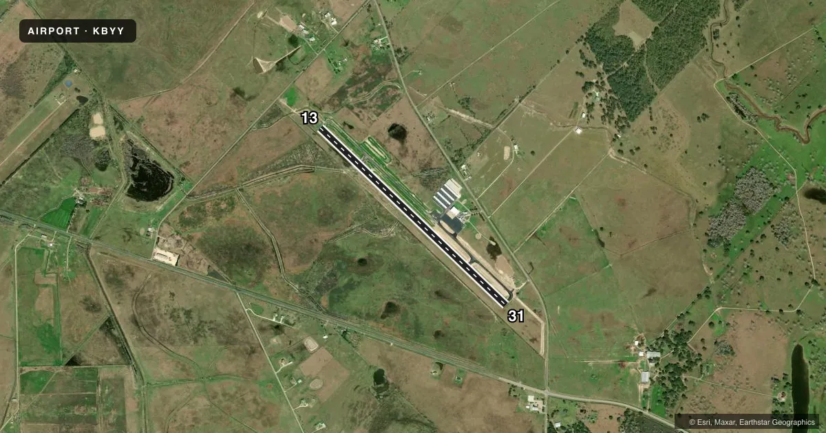
Runways & pattern
Full pagePattern entry · RWY 13
LEFT TRAFFICRunway end performance
| End | TORA | TODA | ASDA | LDA | VGSI | Approach lights | Obstruction |
|---|---|---|---|---|---|---|---|
| 13 | — | — | — | — | PAPI 2-box left(3°) | — | — |
| 31 | — | — | — | — | — | — | 25', pole, 1170' from thr, 300' R of cntrln, slope 38 |
Declared distances in feet. TORA = takeoff run available, TODA = takeoff distance, ASDA = accelerate-stop, LDA = landing distance.
Airport sketch
Runways drawn to scale from FAA survey coordinates, rendered over satellite imagery. Not for navigation.
Approaches & charts
Services on the field
Fuel grades, oxygen, maintenance, ramp storage and lighting — as declared to the FAA by the airport operator.
Fuel & services
- Fuel
- 100LLA
- Other services
- AMB,CHTR,INSTR
Ramp & ground
- Transient storage
- Tie-down
- Hangar
- Landing fee
- No fee published
- Customs
- Not available
- Lighting schedule
- SEE RMK
- Beacon schedule
- SS-SR
- Beacon
- White / Green (civil land)(WG)
- Wind indicator
- Lighted
- Segmented circle
- Yes
Fuel & FBOs
Cheapest 100LL and Jet A on the field and nearby. Always confirm with the FBO before taxi.
Airport notes
Surface conditions, obstructions, local procedures, lighting outages and other notes published with each FAA cycle.
General notes
- TWY REFLECTORS ON ALL TWYS.
- FOR AFT HRS ATTENDANT CALL ARPT NMBR - CALL OUT FEE, TWO HR MIN.
- FOR CD CTC HOUSTON ARTCC AT 281-230-5622.
Lighting notes
- MIRL RWY 13/31 PRESET LOW INTST SS-SR; TO INCR INTST AND ACTVT REIL RWY 13 & 31 - CTAF.
Fuel notes
- 100LL100LL & JET A., 24 HR SELF-SERVICE FUEL. FULL SERV AVAILABLE.
Other notes
- THIS AIRPORT HAS BEEN SURVEYED BY THE NATIONAL GEODETIC SURVEY.
- 1AFTR HRS ATNDT AVBL ON CALL. CALL OUT FEE TWO HR MIN.
- 1ARPT UNATNDD HOLS.
VFR map & nearby airports
VFR sectional. Tap any ICAO chip to open that airport.
Key facts · KBYY
Answer card- ICAO
- KBYY
- Name
- BAY CITY RGNL
- Location
- BAY CITY, TEXAS
- Elevation
- 44.9 ft MSL
- Traffic pattern altitude
- 1,044.9 ft MSL (1,000 AGL)
- Control tower
- Non-towered (use CTAF)
- Total runways
- 1
- Longest runway
- 13/31 · 5,107 ft
- Published ILS approaches
- 0
- Published frequencies
- 2
- Magnetic variation
- 3°
- Current flight rules
- VFR
- Current wind
- 150° at 13 kt
- Favored runway now
- RWY 13
Bay City Rgnl is in Bay City, Texas. The field elevation is 44.9 ft MSL. It has one asphalt runway, 13/31, at 5,107 ft. There is no control tower. CTAF and UNICOM are both 122.8. No ILS approaches are published here.
Pattern altitude is not published. Use 1,000 ft AGL as the standard light-piston pattern unless current local guidance says otherwise. The on-field FBO is Bay City Regional Airport. It carries 100LL, Jet A and Jet A Prist. 24-hour self-service fuel is available. Full service is also available.
A few operational details matter here. Runway lights on 13/31 are preset to low intensity from sunset to sunrise. Use CTAF to increase intensity. Use it to activate the runway end identifier lights. Taxiway reflectors are installed on all taxiways. After-hours attendant service is available on call. There is a call-out fee with a two-hour minimum. The airport is unattended on holidays. For clearance delivery, contact Houston Air Route Traffic Control Center. If you are planning a night arrival or an after-hours stop, verify the current setup with the airport operator or the FBO directly by phone before you go.