METAR & TAF KBTR
Current METAR
Observed 08:53Z
KBTR 270853Z AUTO 27004KT 10SM CLR 26/24 A2997 RMK AO2 SLP148 T02610244 55007 $
- Wind
- 270° @ 4 kt
- Visibility
- 10 SM
- Temp / Dew
- 26°C / 24°C
- Altimeter
- 29.97 inHg
- Clouds
- CLR
- Density alt
- 1,344 ft
- Ceiling
- Unlimited
- Rules
- VFR
Airport info & contacts
Manager on record, flight service, ARTCC, attendance schedule and pattern altitude — published by the FAA and refreshed every 28 days.
Location
- From city
- 4 NM N
- VFR sectional
- HOUSTON
- ARTCC
- ZHU · HOUSTON
- NOTAM facility
- BTR (NOTAM-D)
Airport manager
- Name
- MIKE EDWARDS
- Phone
- 225-355-0333
- Address
- 9430 JACKIE COCHRAN DR. STE 300, BATON ROUGE LA 70807
Flight service · Hours
- FSS DRI
- DE RIDDER1-800-WX-BRIEF
- Attendance
- 0500-0000
Frequencies
Tap any row to copy the frequency to your clipboard.
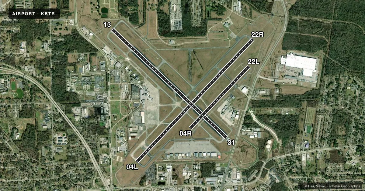
Runways & pattern
Full pagePattern entry · RWY 31
LEFT TRAFFIC| Runway | Heading (°M) | Length | Surface | Traffic |
|---|---|---|---|---|
| 04L/22R | 43° / 223° | 7,500 ft | CONC | 22R R |
| 13/31Favored | 133° / 313° | 7,005 ft | ASPH | Standard L |
| 04R/22L | 43° / 223° | 3,799 ft | ASPH | 04R R |
Runway end performance
| End | TORA | TODA | ASDA | LDA | VGSI | Approach lights | Obstruction |
|---|---|---|---|---|---|---|---|
| 04L | 7,500' | 7,500' | 7,500' | 7,500' | — | — | 52', pole, 2200' from thr, 125' R of cntrln, slope 38 |
| 22R | 7,500' | 7,500' | 7,500' | 7,500' | PAPI 4-box left(3°) | MALSR | — |
| 13 | 7,004' | 7,004' | 6,317' | 5,720' | — | MALSR | 76', pole, 2345' from thr, 103' R of cntrln, slope 28 |
| 31 | 7,004' | 7,004' | 6,407' | 6,094' | VASI 4-box left(3°) | MALS | 11', road, 230' from thr, 503' R of cntrln, slope 2 |
| 04R | 3,799' | 3,799' | 3,799' | 3,799' | — | — | — |
| 22L | 3,799' | 3,799' | 3,799' | 3,799' | — | — | — |
Declared distances in feet. TORA = takeoff run available, TODA = takeoff distance, ASDA = accelerate-stop, LDA = landing distance.
Airport sketch
Runways drawn to scale from FAA survey coordinates, rendered over satellite imagery. Not for navigation.
Approaches & charts
ILS · 2
Services on the field
Fuel grades, oxygen, maintenance, ramp storage and lighting — as declared to the FAA by the airport operator.
Fuel & services
- Fuel
- 100LLA
- Oxygen (bottled)
- High pressure
- Oxygen (bulk)
- High pressure
- Airframe repair
- Major
- Power plant repair
- Major
- Other services
- AFRT,AVNCS,CARGO,CHTR,INSTR,RNTL,SALES
Ramp & ground
- Transient storage
- Tie-down
- Hangar
- Landing fee
- No fee published
- Customs
- Not available
- Lighting schedule
- SEE RMK
- Beacon schedule
- SS-SR
- Beacon
- White / Green (civil land)(WG)
- Wind indicator
- Lighted
- Segmented circle
- Yes
Fuel & FBOs
Cheapest 100LL and Jet A on the field and nearby. Always confirm with the FBO before taxi.
Airport notes
Surface conditions, obstructions, local procedures, lighting outages and other notes published with each FAA cycle.
General notes
- WHEN ATCT CLSD USE FREQ 121.9 TO CTC ARFF FOR EMERG REQ.
- MIGRATORY BIRDS ON & INVOF ARPT DURING MONTHS OF MAR/APR/SEP & OCT.
- TWY E WEIGHT RESTRICTIONS: SINGLE 44,000 LBS; DUAL 55,000 LBS; DUAL TANDEM 93,000 LBS.
- RAMP & TWY LANE ADJ TO THE COMMERICAL AIR CARRIER TERMINAL BLDG IS LMTD TO COMMERICAL AIR CARRIER AND PSGR AIRTAXI ACFT ONLY.
- RWY 4R/22L AND TWY E ARE SIMILAR IN APPRNC. USE CTN WHEN EXITING RWY 13/31.
- FOR CD IF UNA TO CTC ON FSS FREQ, CTC HOUSTON ARTCC AT 281-230-5622.
- TWY E, TWY F BTN RWY 04R-22L AND AER 31 NOT AVBL FOR SKEDD ACR OPS.
- TWY F BTN RWY 04R-22L AND AER 31 RDCS TO 40 FT WID.
- DSGND FREE PUB USE PRKG FOR GA ACFT IN THE BACK ROW OF THE S RAMP.
Lighting notes
- ACTVT MALSR RYS 22R & 13 AND MALS RY 31 - CTAF. WHEN ATCT CLSD HIRL RYS 13/31 & 04L/22R PRESET LOW INTST; TO INCR INTST ACTVT - CTAF. MIRL RY 04R/22L NOT AVBL.
Runway surface & condition
- 04L/22RPCR VALUE: 700/R/A/W/T
- 13/31PCR VALUE: 990/F/D/W/T
- 04R/22LRWY 04R/22L NOT AVBL FOR PART 121/PART 380 OPS WITH SKED PAX CARRYING OPS MORE THAN 9 PAX SEATS AND NON-SKED PAX CARRYING OPS MORE THAN 30 PAX SEATS.
Approach & departure obstructions
- 13+7 FT FENCE 200 FT 406 FT LEFT.
- 31+7 FT FENCE 200 FT 496 FT RIGHT.
- 31+68 FT TREE, 1578 FT, 516 RIGHT.
Other notes
- 24 HRS PPR FOR UNSKED ACR OPNS WITH MORE THAN 30 PSGR SEATS 0000-0500 CALL AMGR 225-355-2068/0333.
- OWNERCITY OF BATON ROUGE AND PARISH OF EAST BATON ROUGE.
VFR map & nearby airports
VFR sectional. Tap any ICAO chip to open that airport.
Key facts · KBTR
Answer card- ICAO
- KBTR
- Name
- BATON ROUGE METRO, RYAN FLD
- Location
- BATON ROUGE, LOUISIANA
- Elevation
- 69.7 ft MSL
- Traffic pattern altitude
- 1,069.7 ft MSL (1,000 AGL)
- Control tower
- Towered · 0500-0000
- Total runways
- 3
- Longest runway
- 04L/22R · 7,500 ft
- Published ILS approaches
- 2
- Published frequencies
- 15
- Magnetic variation
- 0°
- Current flight rules
- VFR
- Current wind
- 270° at 4 kt
- Favored runway now
- RWY 31
KBTR is in Baton Rouge, Louisiana. The field elevation is 69.7 ft MSL. It has three runways. The longest is 7,500 ft on 04L/22R. The airport is towered. The tower hours are 0500-0000. Two ILS approaches are published. They serve runway 13 and runway 22R.
Pattern altitude is not published in the facts block. Use the standard 1,000 ft AGL for light piston traffic unless the current FAA Chart Supplement says otherwise. The airport sits in Class C airspace. That matters for arrivals, departures and radio work in the Baton Rouge area.
On the field, Signature Aviation carries 100LL and Jet A. Williams Jet Center carries 100LL and Jet A. Velocity Aviation, formerly BTR Jet Center, carries 100LL and Jet A Prist. Free public use parking for general aviation aircraft is in the back row of the south ramp. A tree is reported near the departure end of runway 31. Taxiway F narrows between 04R/22L and Aer 31. Runway 04R/22L and taxiway E can look similar from the cockpit. Use extra care when exiting runway 13/31. Runway 04R/22L is also not available for certain large passenger operations. Check the current FAA Chart Supplement for any current operating limits before you go.