METAR & TAF F46
Current METAR
Observed 10:55Z
KF46 271055Z AUTO 20008KT 10SM CLR 26/21 A2994 RMK AO2 T02600211
- Wind
- 200° @ 8 kt
- Visibility
- 10 SM
- Temp / Dew
- 26°C / 21°C
- Altimeter
- 29.94 inHg
- Clouds
- CLR
- Density alt
- 2,007 ft
- Ceiling
- Unlimited
- Rules
- VFR
Airport info & contacts
Manager on record, flight service, ARTCC, attendance schedule and pattern altitude — published by the FAA and refreshed every 28 days.
Location
- From city
- 2 NM E
- VFR sectional
- DALLAS-FT WORTH
- ARTCC
- ZFW · FORT WORTH
- NOTAM facility
- F46 (NOTAM-D)
Airport manager
- Name
- MELISSA HARDIN
- Phone
- 972-771-0151
- Address
- 1701 AIRPORT RD., ROCKWALL TX 75087
Flight service · Hours
- FSS FTW
- FORT WORTH1-800-WX-BRIEF
- Attendance
- 0800-DUSK
Frequencies
Tap any row to copy the frequency to your clipboard.
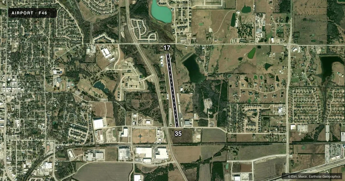
Runways & pattern
Full pagePattern entry · RWY 17
LEFT TRAFFICRunway end performance
| End | TORA | TODA | ASDA | LDA | VGSI | Approach lights | Obstruction |
|---|---|---|---|---|---|---|---|
| 17 | — | — | — | — | — | — | 35', pline, 430' from thr, 0' R of cntrln, slope 6 |
| 35 | — | — | — | — | — | — | 50', trees, 750' from thr, 340' R of cntrln, slope 11 |
Declared distances in feet. TORA = takeoff run available, TODA = takeoff distance, ASDA = accelerate-stop, LDA = landing distance.
Airport sketch
Runways drawn to scale from FAA survey coordinates, rendered over satellite imagery. Not for navigation.
Approaches & charts
Services on the field
Fuel grades, oxygen, maintenance, ramp storage and lighting — as declared to the FAA by the airport operator.
Fuel & services
- Fuel
- 100LLA+
- Oxygen (bottled)
- Not available
- Oxygen (bulk)
- Not available
- Airframe repair
- Major
- Power plant repair
- Major
- Other services
- INSTR,RNTL
Ramp & ground
- Transient storage
- Tie-down
- Landing fee
- No fee published
- Customs
- Not available
- Lighting schedule
- SEE RMK
- Beacon schedule
- SS-SR
- Beacon
- White / Green (civil land)(WG)
- Wind indicator
- Yes
- Segmented circle
- Yes
Fuel & FBOs
Cheapest 100LL and Jet A on the field and nearby. Always confirm with the FBO before taxi.
Airport notes
Surface conditions, obstructions, local procedures, lighting outages and other notes published with each FAA cycle.
General notes
- NO LINE OF SIGHT BTN RWY ENDS.
- RWY 17 50 FT DROP OFF AT APCH END OF PAVEMENT; STEEP DOWN SLOPE ALL SIDES OF DSPLCMT.
- SVRL AREAS RWY & TXY PAVEMENT LIP GTR THAN 3 INS AT EDGE.
- FOR CD CTC LONE STAR APCH AT 972-615-2799.
Lighting notes
- ACTVT LIRL RWY 17/35 - CTAF.
Fuel notes
- 100LLSELF-SVC FUEL.
Approach & departure obstructions
- 1720 FT TREES, 0-200 FT DSTC, 100 FT R.
- 3515 FT RD, 22 FT DSTC, 250 L/R.
- 17APCH RATIO 20:1 AT DSPLCD THR.
- 35APCH RATIO 8:1 AT DSPLCD THR OVR 18 FT HGR 160 FT FM DSPLCD THR 204 FT R.
- 17DUE TO TERRAIN-UNABLE TO ACCURATELY MEASURE OBSTRUCTION CLEARANCE SLOPE.
Other notes
- THIS AIRPORT HAS BEEN SURVEYED BY THE NATIONAL GEODETIC SURVEY.
- MANAGERAMGR CELL, 972-835-5395. F46AVIATIONSERVICES@GMAIL.COM
VFR map & nearby airports
VFR sectional. Tap any ICAO chip to open that airport.
Key facts · F46
Answer card- ICAO
- F46
- Name
- RALPH M HALL/ROCKWALL MUNI
- Location
- ROCKWALL, TEXAS
- Elevation
- 574.1 ft MSL
- Traffic pattern altitude
- 1,574.1 ft MSL (1,000 AGL)
- Control tower
- Non-towered (use CTAF)
- Total runways
- 1
- Longest runway
- 17/35 · 3,373 ft
- Published ILS approaches
- 0
- Published frequencies
- 4
- Magnetic variation
- 5°
- Current flight rules
- VFR
- Current wind
- 200° at 8 kt
- Favored runway now
- RWY 17
Ralph M Hall/Rockwall Muni sits in Rockwall, Texas at 574.1 ft MSL. It has one asphalt runway, 17/35, which is 3,373 ft long. There is no control tower. Lone Star Approach handles clearance delivery and approach or departure services on the published frequencies. No ILS approaches are published here.
Pattern altitude is not published. Use 1,000 ft AGL as the standard light piston pattern unless the current FAA Chart Supplement says otherwise. The field is on CTAF 122.8. UNICOM is also 122.8. F46 Aviation Services is on the field. It carries 100LL and Jet A Prist. Self-serve 100LL is available. Call the FBO at (972) 771-0151 for current ramp or fuel details.
A first-time arrival should pay attention to the published runway notes. Runway 17 has a 50-foot drop off at the approach end of pavement with steep downslope around the displaced area. Runway 17 also has trees near the approach path. Runway 35 has an 18-foot obstruction near the displaced threshold plus a road close to the runway. Several areas of runway and taxiway pavement have a lip greater than 3 inches at the edge. Low intensity runway lights on 17/35 are CTAF-activated. Check the current FAA Chart Supplement for any noise or curfew restrictions before flying in.