METAR & TAF TJIG
Current METAR
Observed 10:45Z
TJIG 271045Z 00000KT 7SM HZ SCT030 SCT060 27/23 A3001 RMK ATIS A RY09 IN USE
- Wind
- 000° @ 0 kt
- Visibility
- 7 SM
- Temp / Dew
- 27°C / 23°C
- Altimeter
- 30.01 inHg
- Clouds
- SCT
- Density alt
- 1,340 ft
- Ceiling
- Unlimited
- Rules
- VFR
Airport info & contacts
Manager on record, flight service, ARTCC, attendance schedule and pattern altitude — published by the FAA and refreshed every 28 days.
Location
- From city
- 0 NM W
- VFR sectional
- PUERTO RICO-VIRGIN ISLANDS
- Pattern altitude
- 990 ft AGL · 1,000 ft MSL
- ARTCC
- ZSU · SAN JUAN
- NOTAM facility
- TJSJ (NOTAM-D)
Airport manager
- Name
- EDGAR M. TORRELLAS
- Phone
- 787-729-8715
- Address
- GPO BOX 362829, SAN JUAN PR 00936
Flight service · Hours
- FSS SJU
- SAN JUAN1-800-WX-BRIEF
- Attendance
- 0600-1930
Frequencies
Tap any row to copy the frequency to your clipboard.
Runways & pattern
Full pagePattern entry · RWY 09
LEFT TRAFFICRunway end performance
| End | TORA | TODA | ASDA | LDA | VGSI | Approach lights | Obstruction |
|---|---|---|---|---|---|---|---|
| 09 | 5,539' | 5,539' | 5,424' | 5,126' | PAPI 2-box right(2.83°) | — | — |
| 27 | 5,539' | 5,539' | 5,239' | 4,299' | — | — | 15', road, 201' from thr, 90' R of cntrln, slope 0 |
Declared distances in feet. TORA = takeoff run available, TODA = takeoff distance, ASDA = accelerate-stop, LDA = landing distance.
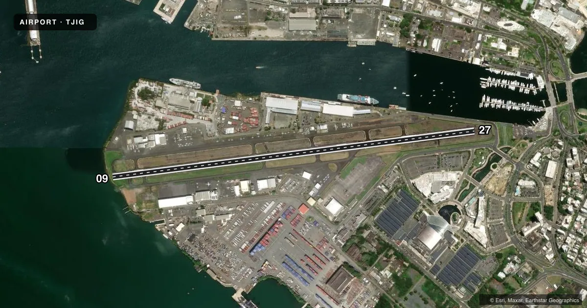
Airport sketch
Runways drawn to scale from FAA survey coordinates, rendered over satellite imagery. Not for navigation.
Approaches & charts
Services on the field
Fuel grades, oxygen, maintenance, ramp storage and lighting — as declared to the FAA by the airport operator.
Fuel & services
- Fuel
- 100A
- Oxygen (bottled)
- HIGH/LOW
- Oxygen (bulk)
- Not available
- Airframe repair
- Major
- Power plant repair
- Major
- Other services
- AFRT,AVNCS,CHTR,INSTR,RNTL
Ramp & ground
- Transient storage
- Tie-down
- Landing fee
- Yes
- Customs
- Not available
- Lighting schedule
- SEE RMK
- Beacon schedule
- SS-SR
- Beacon
- White / Green (civil land)(WG)
- Wind indicator
- Lighted
- Segmented circle
- No
Fuel & FBOs
Cheapest 100LL and Jet A on the field and nearby. Always confirm with the FBO before taxi.
Airport notes
Surface conditions, obstructions, local procedures, lighting outages and other notes published with each FAA cycle.
General notes
- FEE FOR ALL ACFT.
- WHEN ATCT CLSD STRAIGHT IN PATTERN NOT AUTHORIZED.
- CUSTOMS/IMMIGRATION OPR HRS 1400-2400Z. 787-289-7978 / 7979. AFTR HRS 787-729-6600.
- RWY 9/27 ACFT WITH WINGSPAN OVER 79 FT, ARPT DOES NOT MEET DESIGN STD FOR WING CLNC.
- INDEX A-1 ARFF EQUIPMENT AVAIL 0600-1930.
- SAN JUAN BAY CRUISE SHIP MANEUVERING AREA. TALL VESSEL OBSTRUCTION ON FINAL APPROACH TO RWY 9 OR DEPARTING RWY 27.
- RWY 27 APCH END, RWY 9 DEP END, TALL VESSELS AT MARINA.
- 346 FT HIGH LGTD CRANES, 0.5 MI SE AER 09. EXERCISE CTN USING RITE TFC PAT FOR RWY 09.
- WHEN TWR CLSD CTC SAN JUAN CERAP AT 787-253-8664 / 8664
- TWY A4, A5, & A6 CLSD TO ACFT WITH WINGSPAN MORE THAN 49 FT.
Lighting notes
- AFTR TWR HRS ACTVT MIRLS RWY 9/27 - CTAF.
Runway surface & condition
- 09/27PCR VALUE: 269/F/A/X/T
Approach & departure obstructions
- 2715 FT RD, 0-199 FT DSTC, 80 FT R, 210 FT L.
- 09HELICOPTERS OCNLY USE RT TFC RWY 9 WHEN DIR BY ATCT.
- 09OCNL 90 FT BOATS, 0-200 FT DSTC, 220 FT R.
Other notes
- MANAGERAMGR EXT 3331, OPS EXT 3332.
VFR map & nearby airports
VFR sectional. Tap any ICAO chip to open that airport.
Key facts · TJIG
Answer card- ICAO
- TJIG
- Name
- FERNANDO LUIS RIBAS DOMINICCI
- Location
- SAN JUAN, PUERTO RICO
- Elevation
- 9.6 ft MSL
- Traffic pattern altitude
- 999.6 ft MSL (990 AGL)
- Control tower
- Towered · 0700-1900
- Total runways
- 1
- Longest runway
- 09/27 · 5,539 ft
- Published ILS approaches
- 0
- Published frequencies
- 9
- Magnetic variation
- 12°
- Current flight rules
- VFR
- Current wind
- 000° at 0 kt
- Favored runway now
- –
Fernando Luis Ribas Dominicci is in San Juan, Puerto Rico. The field elevation is 9.6 ft MSL. TJIG has one runway, 09/27, which is 5,539 ft long. The tower is open from 0700 to 1900. No ILS approaches are published here. Pattern altitude is 990 ft AGL, or 999.6 ft MSL.
This is a coastal airport with busy water traffic nearby. The Chart Supplement notes San Juan Bay cruise ship maneuvering areas. It also calls out a tall vessel obstruction on final to runway 09 or when departing runway 27. There are 346 ft lighted cranes about 0.5 mile southeast of the aerodrome. Birds are also reported on and near the airport. Pilots should pay close attention to the right traffic pattern for runway 09. When the tower is closed, straight-in pattern operations are not authorized.
Modern Aviation is on the field. It carries 100LL, Jet A and Jet A Prist. Isla Grande Flying School is also on the field. It carries 100LL. The published remarks also note pilot-controlled lighting with 3 clicks low, 5 clicks medium, or 7 clicks high. Taxiways A and B use CTAF. Customs and immigration hours are published in the Chart Supplement, so verify current entry details before arrival.