METAR & TAF PHMK
Current METAR
Observed 22:54Z
PHMK 092254Z 06018G31KT 10SM CLR 29/21 A3008 RMK AO2 PK WND 07031/2253 SLP185 T02890211 $
- Wind
- 060° @ 18G31 kt
- Visibility
- 10 SM
- Temp / Dew
- 29°C / 21°C
- Altimeter
- 30.08 inHg
- Clouds
- CLR
- Density alt
- 2,044 ft
- Ceiling
- Unlimited
- Rules
- VFR
Airport info & contacts
Manager on record, flight service, ARTCC, attendance schedule and pattern altitude — published by the FAA and refreshed every 28 days.
Location
- From city
- 6 NM NW
- VFR sectional
- HAWAIIAN ISLANDS
- ARTCC
- ZHN · HONOLULU CONTROL FACILITY
- NOTAM facility
- MKK (NOTAM-D)
Airport manager
- Name
- MARVIN MONIZ
- Phone
- 808-281-9898
- Address
- KAHULUI ARPT, KAHULUI HI 96732
Flight service · Hours
- FSS HNL
- HONOLULU1-800-WX-BRIEF
- Attendance
- 0500-2015
Frequencies
Tap any row to copy the frequency to your clipboard.
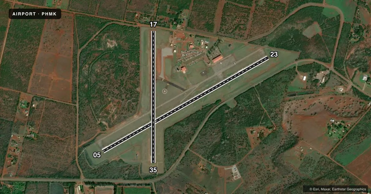
Runways & pattern
Full pagePattern entry · RWY 05
LEFT TRAFFIC| Runway | Heading (°M) | Length | Surface | Traffic |
|---|---|---|---|---|
| 05/23Favored | 49° / 229° | 4,494 ft | ASPH | Standard L |
| 17/35 | 169° / 349° | 3,118 ft | ASPH | Standard L |
Runway end performance
| End | TORA | TODA | ASDA | LDA | VGSI | Approach lights | Obstruction |
|---|---|---|---|---|---|---|---|
| 05 | 4,494' | 4,494' | 4,494' | 4,494' | PAPI 4-box left(4°) | — | — |
| 23 | 4,494' | 4,494' | 4,494' | 3,901' | — | — | 23', brush, 400' from thr, 0' R of cntrln, slope 17 |
| 17 | 3,118' | 3,118' | 3,118' | 2,692' | — | — | 12', fence, 80' from thr, 0' R of cntrln, slope 0 |
| 35 | 3,118' | 3,118' | 3,118' | 3,118' | — | — | 4', fence, 248' from thr, 0' R of cntrln, slope 12 |
Declared distances in feet. TORA = takeoff run available, TODA = takeoff distance, ASDA = accelerate-stop, LDA = landing distance.
Airport sketch
Runways drawn to scale from FAA survey coordinates, rendered over satellite imagery. Not for navigation.
Approaches & charts
Services on the field
Fuel grades, oxygen, maintenance, ramp storage and lighting — as declared to the FAA by the airport operator.
Fuel & services
- Fuel
- Not available
- Other services
- AFRT,CARGO
Ramp & ground
- Transient storage
- Tie-down
- Landing fee
- No fee published
- Customs
- Not available
- Lighting schedule
- SEE RMK
- Beacon schedule
- SS-SR
- Beacon
- White / Green (civil land)(WG)
- Wind indicator
- Lighted
- Segmented circle
- Yes
Fuel & FBOs
Cheapest 100LL and Jet A on the field and nearby. Always confirm with the FBO before taxi.
Airport notes
Surface conditions, obstructions, local procedures, lighting outages and other notes published with each FAA cycle.
General notes
- 24 HRS PPR FOR DIVISION 1.1,1.2,1.3 EXPLOSIVES AND 4 HRS PPR FOR OTHER HAZARDOUS MATERIAL IN/OUT OF ARPT CTC 808-567-6140/6008.
- MTN APPROXIMATELY 1280' MSL LCTD 2.8 NM FROM RWY 05 THR ON CNTRLN EXTDD.
- BE ALERT TO EGRETS AND PIGEONS ON & INVOF ARPT.
- LARGE ACFT WITH WINGSPAN GREATER THAN 78 FT MAY NOT USE TWY A OR RY 05/23 FOR SIMULTANEOUS OPNS.
- (E94) LAWRS AVBL FROM TWR PERSONNEL 0600-1900 LCL.
- STANDING WATER/PONDING ON RY 17/35 NEAR TWY ECHO DURING INCLEMENT WEATHER.
- FOR CD WHEN ATCT IS CLSD CTC HONOLULU CONTROL FACILITY AT 808-840-6262.
Lighting notes
- WHEN ATCT CLSD ACTVT MIRL RY 05/23 AND RY 17/35, REIL RY 05 - CTAF.
Runway surface & condition
- 05/23PCR VALUE: 104/F/A/X/T
- 17/35PCR VALUE: 124/F/B/X/T
Approach & departure obstructions
- 05PAPI NOT AUTHORIZED 1.8 NM BYD LDG THLD DUE TO RAPIDLY RISING TERRAIN.
- 17APCH RATIO 23:1 FROM DSPLCD THLD.
- 23APCH RATIO FROM DSPLCD THLD 23:1.
- 23BRUSH 1900' FROM DSPLCD THR.
Other notes
- THIS AIRPORT HAS BEEN SURVEYED BY THE NATIONAL GEODETIC SURVEY.
- ARPT CLOSED TO AIR CARRIER OPS WITH 10 OR MORE PASSENGER SEATS 1930-0600 EXCEPT PPR, CALL 808-567-9660/9663.
- <TPA SMALL ACFT 1250' MSL. LARGE ACFT 1950' MSL.
- MANAGERARPT OPNS/MAINT/AOM/MR. ANTONE KALILIKANE (808) 567-9660.
VFR map & nearby airports
VFR sectional. Tap any ICAO chip to open that airport.
Key facts · PHMK
Answer card- ICAO
- PHMK
- Name
- MOLOKAI
- Location
- KAUNAKAKAI, HAWAII
- Elevation
- 453.9 ft MSL
- Traffic pattern altitude
- 1,453.9 ft MSL (1,000 AGL)
- Control tower
- Towered · 0600-1830
- Total runways
- 2
- Longest runway
- 05/23 · 4,494 ft
- Published ILS approaches
- 0
- Published frequencies
- 7
- Magnetic variation
- 11°
- Current flight rules
- VFR
- Current wind
- 060° at 18 kt
- Favored runway now
- RWY 05
Molokai Airport sits near Kaunakakai on Molokai in Hawaii. Field elevation is 453.9 ft MSL. The airport has 2 asphalt runways. The longest is runway 05/23 at 4,494 ft. Tower service is published from 0600 to 1830. When the tower is closed, clearance delivery goes through Honolulu Control Facility. No ILS approaches are published here, so plan with the current chart and weather in mind.
Pattern altitude is published as 1,250 ft MSL for small aircraft. Large aircraft use 1,950 ft MSL. That matters here because the field is on an island with active traffic and changing weather. Runway 17/35 has a published pavement classification number of 124/F/B/X/T. Runway 05/23 is 104/F/A/X/T. Brush is reported 1,900 ft from the displaced threshold of runway 23. Standing water and ponding can show up on runway 17/35 near taxiway Echo during inclement weather.
There are no on-field FBOs listed. Check with the airport operator or the field directly before arrival for current services. Large aircraft with wingspans greater than 78 ft may not use taxiway A or runway 05/23 for simultaneous operations. If you are bringing hazardous material or special cargo, the published prior permission rules apply. The airport manager is Mr. Antone Kalilikane.