METAR & TAF PHJR
Current METAR
Observed 19:53Z
PHJR 081953Z 08007G20KT 040V110 10SM CLR 30/19 A3007 RMK AO2 SLP188 T03000189 $
- Wind
- 080° @ 7G20 kt
- Visibility
- 10 SM
- Temp / Dew
- 30°C / 19°C
- Altimeter
- 30.07 inHg
- Clouds
- CLR
- Density alt
- 1,654 ft
- Ceiling
- Unlimited
- Rules
- VFR
Airport info & contacts
Manager on record, flight service, ARTCC, attendance schedule and pattern altitude — published by the FAA and refreshed every 28 days.
Location
- From city
- 2 NM S
- VFR sectional
- HAWAIIAN ISLANDS
- ARTCC
- ZHN · HONOLULU CONTROL FACILITY
- NOTAM facility
- JRF (NOTAM-D)
Airport manager
- Name
- MALCOM SMITH
- Phone
- 808-836-6533
- Address
- 300 RODGERS BLVD #12, HONOLULU HI 96819-1897
Flight service · Hours
- FSS HNL
- HONOLULU1-800-WX-BRIEF
- Attendance
- 0630-1430
Frequencies
Tap any row to copy the frequency to your clipboard.
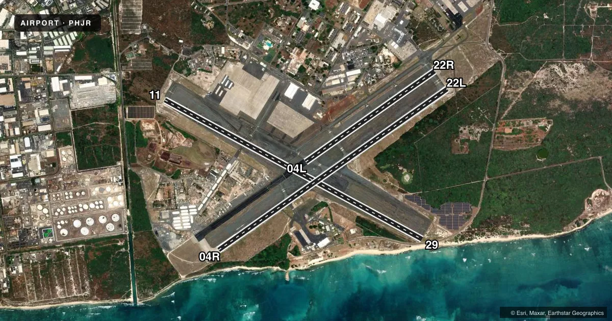
Runways & pattern
Full pagePattern entry · RWY 04R
LEFT TRAFFIC| Runway | Heading (°M) | Length | Surface | Traffic |
|---|---|---|---|---|
| 11/29 | 107° / 287° | 8,365 ft | ASPH | Standard L |
| 04R/22LFavored | 44° / 224° | 7,989 ft | ASPH | Standard L |
| 04L/22R | 44° / 224° | 4,505 ft | ASPH | Standard L |
Runway end performance
| End | TORA | TODA | ASDA | LDA | VGSI | Approach lights | Obstruction |
|---|---|---|---|---|---|---|---|
| 11 | — | — | — | — | PAPI 4-box left(3°) | — | — |
| 29 | — | — | — | — | PAPI 4-box left(3°) | — | — |
| 04R | — | — | — | — | PAPI 4-box left(3°) | — | — |
| 22L | — | — | — | — | PAPI 4-box left(3°) | — | — |
| 04L | — | — | — | — | PAPI 2-box left(3°) | — | — |
| 22R | — | — | — | — | PAPI 2-box left(3°) | — | — |
Declared distances in feet. TORA = takeoff run available, TODA = takeoff distance, ASDA = accelerate-stop, LDA = landing distance.
Airport sketch
Runways drawn to scale from FAA survey coordinates, rendered over satellite imagery. Not for navigation.
Approaches & charts
Services on the field
Fuel grades, oxygen, maintenance, ramp storage and lighting — as declared to the FAA by the airport operator.
Fuel & services
- Fuel
- 100LLAA1
- Oxygen (bottled)
- Not available
- Oxygen (bulk)
- Not available
- Other services
- CHTR,INSTR,RNTL,SURV
Ramp & ground
- Transient storage
- Tie-down
- Lighting schedule
- SEE RMK
- Beacon schedule
- SS-SR
- Beacon
- White / Green (civil land)(WG)
- Wind indicator
- Lighted
- Segmented circle
- Yes
Fuel & FBOs
Cheapest 100LL and Jet A on the field and nearby. Always confirm with the FBO before taxi.
Airport notes
Surface conditions, obstructions, local procedures, lighting outages and other notes published with each FAA cycle.
General notes
- TSNT ACFT CTC FBO FOR FUEL 808-490-2400.
- CTN WAKE TURB FROM JET ACFT LDG AND DEPARTING RWY 04R.
- POTENTIAL HYDROPLANING ALL ACFT DUE STANDING WATER AT INTXN RY 04R AND RY 11.
- OCNL BIRD HAZ APCH END RY 04L AND RY 04R.
- MILITARY HELICOPTER OPNS ON & INVOF ARPT DUE TO USCG MILITARY HELIPAD NEAR RY 04R.
- AVOID OVERFLIGHT REFINERIES WEST OF ARPT, GASEOUS EXHAUST PLUMES AND FLAMES MAY RISE TO 267 FT AGL WITHOUT WARNING.
- NAVAIR 0800 R-14 NATOPS US NAVY AIRCRAFT FIREFIGHTERS AND RESCUE MANUAL, CATEGORY II AIRFIELD (ARFF INDEX B EQUIVALENT).
Lighting notes
- WHEN ATCT CLSD ACTVT MIRL RWY 04R/22L; MIRL RWY 04L/22R; MIRL RWY 11/29; TWY LIGHTS - CTAF. PAPI RWYS 04L, 04R, 11, 22L, 22R, & 29 OPER CONSLY.
Runway surface & condition
- 11/29GROSS WT (IN THSDS) SINGLE-TANDEM: 189.
- 04R/22LPCR VALUE: 602/F/A/X/T
- 11/29PCR VALUE: 602/F/A/X/T
- 04L/22RPCR VALUE: 602/F/A/X/T
Approach & departure obstructions
- 11LARGE ACFT REQUESTING RWY 11 CAN EXPECT RIGHT TRAFFIC.
- 29OTS INDEFLY.
- 22ROTS INDEFLY.
- 04LOTS INDEFLY.
- 04ROTS INDEFLY.
- 11OTS INDEFLY.
- 22LOTS INDEFLY.
Other notes
- SMALL ACFT 800 FT, LARGE ACFT 1000 FT.
VFR map & nearby airports
VFR sectional. Tap any ICAO chip to open that airport.
Key facts · PHJR
Answer card- ICAO
- PHJR
- Name
- KALAELOA (JOHN RODGERS FLD)
- Location
- KAPOLEI, HAWAII
- Elevation
- 32.3 ft MSL
- Traffic pattern altitude
- 1,032.3 ft MSL (1,000 AGL)
- Control tower
- Towered · 0600-2200
- Total runways
- 3
- Longest runway
- 11/29 · 8,365 ft
- Published ILS approaches
- 0
- Published frequencies
- 12
- Magnetic variation
- 11°
- Current flight rules
- VFR
- Current wind
- 080° at 7 kt
- Favored runway now
- RWY 04R
KALAELOA (John Rodgers Fld) sits in Kapolei on the west side of Oahu in Hawaii. Field elevation is 32.3 ft MSL. The airport has three asphalt runways. The longest is runway 11/29 at 8,365 ft. Tower service is published from 0600 to 2200. No ILS approaches are published here.
Pattern altitude is not published in the standard way, so use the FAA remarks. Small aircraft use 800 ft AGL. Large aircraft use 1,000 ft AGL. Million Air Honolulu is on the field. They carry AVGAS 100LL, JET A and JET A Prist. Call (808) 490-2400 for fuel or current ramp details.
This is busy airspace with jet traffic and military helicopter activity near the field. Watch for wake turbulence, especially near runway 04R. The remarks also call out standing water at the intersection of runways 04R and 11, so hydroplaning is a real concern after rain. Visual glide slope indicators on runways 11 and 29 are out of service. When the tower is closed, lights for the runways and taxiways are activated on CTAF. Avoid overflying the refineries west of the airport.