METAR & TAF PHPA
PHPA does not publish a METAR.
Showing the nearest reporting station: PHLI (LIHUE) · 15.5 NM away. Conditions at PHPA may differ.
METAR · PHLI
Observed 16:53Z
PHLI 081653Z 05014KT 10SM FEW023 SCT029 SCT043 25/21 A3007
- Wind
- 050° @ 14 kt
- Visibility
- 10 SM
- Temp / Dew
- 25°C / 21°C
- Altimeter
- 30.07 inHg
- Clouds
- SCT
- Density alt
- 1,044 ft
- Ceiling
- Unlimited
- Rules
- VFR
Airport info & contacts
Manager on record, flight service, ARTCC, attendance schedule and pattern altitude — published by the FAA and refreshed every 28 days.
Location
- From city
- 1 NM SW
- VFR sectional
- HAWAIIAN ISLANDS
- Pattern altitude
- 800 ft AGL · 824 ft MSL
- ARTCC
- ZHN · HONOLULU CONTROL FACILITY
- NOTAM facility
- LIH (NOTAM-D)
Airport manager
- Name
- CRAIG DAVIS
- Phone
- 808-274-3800
- Address
- LIHUE ARPT, LIHUE HI 96766
Flight service · Hours
- FSS HNL
- HONOLULU1-800-WX-BRIEF
- Attendance
- Unattended
Frequencies
Tap any row to copy the frequency to your clipboard.
Runways & pattern
Full pagePattern entry · RWY 09
RIGHT TRAFFICRunway end performance
| End | TORA | TODA | ASDA | LDA | VGSI | Approach lights | Obstruction |
|---|---|---|---|---|---|---|---|
| 09 | 2,361' | 2,361' | 2,361' | 2,361' | — | — | — |
| 27 | 2,450' | 2,450' | 2,450' | 2,450' | — | — | — |
Declared distances in feet. TORA = takeoff run available, TODA = takeoff distance, ASDA = accelerate-stop, LDA = landing distance.
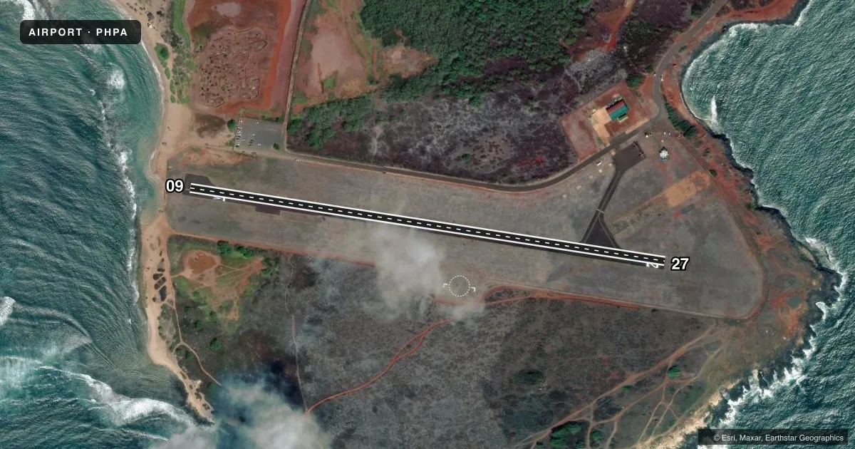
Airport sketch
Runways drawn to scale from FAA survey coordinates, rendered over satellite imagery. Not for navigation.
Approaches & charts
Services on the field
Fuel grades, oxygen, maintenance, ramp storage and lighting — as declared to the FAA by the airport operator.
Fuel & services
- Fuel
- Not available
- Other services
- PAJA
Ramp & ground
- Transient storage
- Tie-down
- Hangar
- Landing fee
- No fee published
- Customs
- Not available
- Wind indicator
- Yes
- Segmented circle
- Yes
Fuel & FBOs
Cheapest 100LL and Jet A on the field and nearby. Always confirm with the FBO before taxi.
Airport notes
Surface conditions, obstructions, local procedures, lighting outages and other notes published with each FAA cycle.
General notes
- NOISE ABATEMENT: AVOID OVERFLIGHT OF THE SALT POND, STATE RECREATIONAL BEACH PARK. RESIDENTIAL AND COMMERCIAL AREAS NORTH OF AIRFIELD.
- SKYDIVING ON AND INVOF ARPT.
- DAILY HELICOPTER ACTIVITY ON AND INVOF ARPT.
- NO AIRFIELD SECURITY, OVERNIGHT AIRCRAFT PARKING NOT AUTHORIZED
- FOR CD CTC HONOLULU CONTROL FACILITY AT 808-840-6262.
- MEDIUM AND SMALL BIRD ACT INVOF RWY.
Runway surface & condition
- 09/27ARPT RSTRD BY OWNER TO ACFT WEIGHING LESS THAN 12500 LBS.
Approach & departure obstructions
- 09+4 FT FENCE 90 FT FROM DISPL THRHLD ACROSS APCH.
Other notes
- FOR AVN INFO 2200-0600 CTC HONOLULU FSS ON 122.6.
- MANAGERKAUAI AIRPORT DISTRICT MANAGER
VFR map & nearby airports
VFR sectional. Tap any ICAO chip to open that airport.
Key facts · PHPA
Answer card- ICAO
- PHPA
- Name
- PORT ALLEN
- Location
- HANAPEPE, HAWAII
- Elevation
- 24 ft MSL
- Traffic pattern altitude
- 824 ft MSL (800 AGL)
- Control tower
- Non-towered (use CTAF)
- Total runways
- 1
- Longest runway
- 09/27 · 2,450 ft
- Published ILS approaches
- 0
- Published frequencies
- 1
- Magnetic variation
- 11°
- Current flight rules
- VFR
- Current wind
- 050° at 14 kt
- Favored runway now
- RWY 09
Port Allen is in Hanapepe, Hawaii on Kauai. Field elevation is 24 ft MSL. The airport has one runway, 09/27, which is 2,450 ft long. It is a non-towered field. CTAF is 122.9.
Pattern altitude is 800 ft AGL, which is 824 ft MSL. No ILS approaches are published. The runway is asphalt. Published remarks say the airport is restricted by the owner to aircraft under 12,500 pounds. That matters for planning, especially if you are bringing a heavier airplane.
Noise abatement is important here. Avoid overflight of the salt pond, the state recreational beach park and the residential and commercial areas north of the airfield. Bird activity is reported near the runway. Skydiving also occurs on and near the airport. Daily helicopter traffic is part of the picture too.
There are no on-field FBOs listed in the facts. Check with the airport operator or the FBO directly by phone for current services before you go. No airfield security is provided. Overnight aircraft parking is not authorized. For information from 2200 to 0600, contact Honolulu Flight Service Station on 122.6. For clearance delivery, contact Honolulu Control Facility at 808-840-6262. The field sits close to sea level, so density altitude is usually less of a concern than runway length, traffic mix and staying clear of the published noise-sensitive areas.