METAR & TAF PHDH
PHDH does not publish a METAR.
Showing the nearest reporting station: PHJR (KALAELOA (JOHN RODGERS FLD)) · 17.8 NM away. Conditions at PHDH may differ.
METAR · PHJR
Observed 16:53Z
PHJR 091653Z AUTO 04004KT 10SM FEW037 24/20 A3008 RMK AO2 SLP193 T02440200 TSNO
- Wind
- 040° @ 4 kt
- Visibility
- 10 SM
- Temp / Dew
- 24°C / 20°C
- Altimeter
- 30.08 inHg
- Clouds
- FEW
- Density alt
- 899 ft
- Ceiling
- Unlimited
- Rules
- VFR
Airport info & contacts
Manager on record, flight service, ARTCC, attendance schedule and pattern altitude — published by the FAA and refreshed every 28 days.
Location
- From city
- 2 NM W
- VFR sectional
- HAWAIIAN ISLANDS
- Pattern altitude
- 786 ft AGL · 800 ft MSL
- ARTCC
- ZHN · HONOLULU CONTROL FACILITY
- NOTAM facility
- HNL (NOTAM-D)
Airport manager
- Name
- MALCOM SMITH
- Phone
- 808-836-6533
- Address
- 300 RODGERS BLVD NR 12, HONOLULU HI 96819-1897
Flight service · Hours
- FSS HNL
- HONOLULU1-800-WX-BRIEF
- Attendance
- 0700-1530
Frequencies
Tap any row to copy the frequency to your clipboard.
Runways & pattern
Full pagePattern entry · RWY 08
LEFT TRAFFICRunway end performance
| End | TORA | TODA | ASDA | LDA | VGSI | Approach lights | Obstruction |
|---|---|---|---|---|---|---|---|
| 26 | — | — | — | — | — | — | 60', trees, 1400' from thr, 100' R of cntrln, slope 20 |
Declared distances in feet. TORA = takeoff run available, TODA = takeoff distance, ASDA = accelerate-stop, LDA = landing distance.
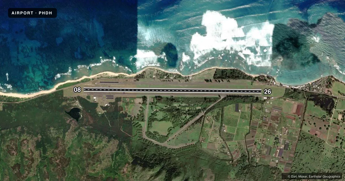
Airport sketch
Runways drawn to scale from FAA survey coordinates, rendered over satellite imagery. Not for navigation.
Approaches & charts
Services on the field
Fuel grades, oxygen, maintenance, ramp storage and lighting — as declared to the FAA by the airport operator.
Fuel & services
- Fuel
- 100A
- Airframe repair
- Major
- Power plant repair
- Major
- Other services
- GLD,INSTR,PAJA
Ramp & ground
- Transient storage
- Tie-down
- Landing fee
- No fee published
- Customs
- Not available
- Wind indicator
- Yes
- Segmented circle
- No
Fuel & FBOs
Cheapest 100LL and Jet A on the field and nearby. Always confirm with the FBO before taxi.
Airport notes
Surface conditions, obstructions, local procedures, lighting outages and other notes published with each FAA cycle.
General notes
- SIMULTANEOUS GLIDER/POWERED ACFT OPNS.
- EXTNSV MIL HELICOPTER & GLIDER OPNS DAILY. AEROBATIC TRAINING OFFSHORE N OF AIRFIELD ABV 1500'.
- CLSD TO CIVIL ACFT 1900-0700 APR 1-SEP 30 AND 1800-0600 OCT 1-MAR 31.
- SKY DIVING ACTIVITY ON AND INVOF ARPT.
- CTN: LARGE SEA BIRDS ON AND INVOF ARPT NOVEMBER THROUGH APRIL.
- NO RUNNING LNDGS WITH SKID TYPE HELICOPTER ON RWY - APVD TWYS ONLY.
- A 5000 X 75 FT RWY FOR LGT POWERED ACFT HAS BEEN PAINTED IN THE CENTER OF EXISTING 9007 X 75 FT PAVED AREA FOR CIVIL USE STARTING APPROX 2000 FT FM EACH RWY END.
- POWERED ACFT SHALL KEEP BASE LEG IN CLOSE AND CROSS THE ARPT BOUNDARY FENCES AT OR ABOVE 600 FT MSL IN ORDER TO ASSURE SAFE SEPARATION FROM SAILPLANES/TOWPLANES USING THE FIRST 2000 FT (SHORT OF THE DSPLCE THLD).
- ULTRALIGHTS ON & INVOF ARPT.
- TREE LINE WITH 90 FT TREES NORTH & SOUTH OF RY APRXLY 425 FT FROM CNTRLN.
- MARKED DEPRESSION INVOF THE AUTOMATED FUEL PUMP ON SOUTHWESTERN APRON.
- PPR FOR CIVIL ACFT 12500 LBS AND OVER, CTC ARPT AIRSIDE OPS MGR AT (808) 836-6428 MON-FRI, 0745-1630.
- RSTD: PPR MUST BE MADE NO LESS THAN 72 HRS FOR ALL MIL FIXED WING ACFT INTO ARPT. CTC USA HAWAII RANGE CTL C808-787-5126/5103.
- FOR CD CTC HONOLULU CONTROL FACILITY AT 808-840-6262.
Runway surface & condition
- 08/26RWY 08/26 CLSD FOR MILITARY TRAINING 0800-1700Z.
Approach & departure obstructions
- 0850:1 TO DSPLCD THR.
- 26APCH RATIO 50:1 TO DSPLCD THLD.
Other notes
- LCTD WITHIN DILLINGHAM MILITARY RESERVATION.
- OPEN TO CIVIL USE THRU AGRMT BTN US ARMY & ST OF HAWAII-CHECK NOTAMS PRIOR TO USE-NO ATCT IN OPN.
- UNICOM OPER 0900-1700.
- WIND INDCRS ARE NOT LGTD.
- OWNERUS ARMY SUPPORT COMMAND HI, FORT SHAFTER HI 96858.
- MANAGERCUSTODIAN ATTENDANT AT ARPT M-F 0630-1430.
- MANAGERPHONE AT ARPT 637-8270. FAX 637-8291. UNICOM OPERATOR 637-8271.
VFR map & nearby airports
VFR sectional. Tap any ICAO chip to open that airport.
Key facts · PHDH
Answer card- ICAO
- PHDH
- Name
- KAWAIHAPAI AIRFIELD
- Location
- MOKULEIA, HAWAII
- Elevation
- 14.2 ft MSL
- Traffic pattern altitude
- 800.2 ft MSL (786 AGL)
- Control tower
- Non-towered (use CTAF)
- Total runways
- 1
- Longest runway
- 08/26 · 9,007 ft
- Published ILS approaches
- 0
- Published frequencies
- 2
- Magnetic variation
- 11°
- Current flight rules
- VFR
- Current wind
- 040° at 4 kt
- Favored runway now
- RWY 08
Kawaihapai Airfield sits in Mokuleia on Oahu in Hawaii. Field elevation is 14.2 ft MSL. The airport has one runway, 08/26, at 9,007 ft. It is a long paved runway, but civil use is under agreement and you should check NOTAMs before you go. There is no control tower. CTAF and UNICOM are both 123.0.
Pattern altitude is 786 ft AGL, which is 800.2 ft MSL. No ILS approaches are published. North Shore Aviation Services is on the field. It carries JET_A. The published remarks also note simultaneous glider and powered aircraft operations. That matters here. Keep your scan sharp in the pattern and on final.
This field is inside Dillingham Military Reservation. Civil aircraft are closed out during the published night hours, so verify the current Chart Supplement and NOTAMs before departure. Runway 08/26 is also closed for military training from 0800 to 1700 Zulu. Wind indicators are not lighted. Large sea birds are a known issue from November through April. There is also a 5,000 ft by 75 ft painted civil-use runway area centered within the paved surface. First-time visitors should brief the field carefully. Stay alert for mixed traffic. Confirm current operating status before launch.