METAR & TAF PHNY
Current METAR
Observed 06:56Z
PHNY 080656Z AUTO 07009G25KT 040V100 10SM CLR 22/18 A3007 RMK AO2 PK WND 06027/0612 SLP161 T02170183 $
- Wind
- 070° @ 9G25 kt
- Visibility
- 10 SM
- Temp / Dew
- 22°C / 18°C
- Altimeter
- 30.07 inHg
- Clouds
- CLR
- Density alt
- 2,276 ft
- Ceiling
- Unlimited
- Rules
- VFR
Airport info & contacts
Manager on record, flight service, ARTCC, attendance schedule and pattern altitude — published by the FAA and refreshed every 28 days.
Location
- From city
- 3 NM SW
- VFR sectional
- HAWAIIAN ISLANDS
- ARTCC
- ZHN · HONOLULU CONTROL FACILITY
- NOTAM facility
- LNY (NOTAM-D)
Airport manager
- Name
- MARVIN MONIZ
- Phone
- 808-281-8801
- Address
- KAHULUI ARPT, KAHULUI HI 96732
Flight service · Hours
- FSS HNL
- HONOLULU1-800-WX-BRIEF
- Attendance
- 0600-1800
Frequencies
Tap any row to copy the frequency to your clipboard.
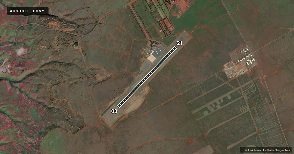
Runways & pattern
Full pagePattern entry · RWY 03
LEFT TRAFFICRunway end performance
| End | TORA | TODA | ASDA | LDA | VGSI | Approach lights | Obstruction |
|---|---|---|---|---|---|---|---|
| 03 | 5,000' | 5,000' | 5,000' | 5,000' | PAPI 4-box right(3°) | — | — |
| 21 | 5,000' | 5,000' | 5,000' | 5,000' | PAPI 4-box left(3.76°) | — | 20', ant, 1000' from thr, 250' R of cntrln, slope 40 |
Declared distances in feet. TORA = takeoff run available, TODA = takeoff distance, ASDA = accelerate-stop, LDA = landing distance.
Airport sketch
Runways drawn to scale from FAA survey coordinates, rendered over satellite imagery. Not for navigation.
Approaches & charts
ILS · 1
Services on the field
Fuel grades, oxygen, maintenance, ramp storage and lighting — as declared to the FAA by the airport operator.
Fuel & services
- Fuel
- A
- Oxygen (bottled)
- Not available
- Oxygen (bulk)
- Not available
- Airframe repair
- Not available
- Power plant repair
- Not available
- Other services
- AFRT,CARGO
Ramp & ground
- Transient storage
- Tie-down
- Landing fee
- No fee published
- Customs
- Not available
- Lighting schedule
- SEE RMK
- Beacon schedule
- SEE RMK
- Beacon
- White / Green (civil land)(WG)
- Wind indicator
- Lighted
- Segmented circle
- No
Fuel & FBOs
Cheapest 100LL and Jet A on the field and nearby. Always confirm with the FBO before taxi.
Airport notes
Surface conditions, obstructions, local procedures, lighting outages and other notes published with each FAA cycle.
General notes
- SEE AREA NOTICES, TFC ADVYS AT NON-TWR ARPTS.
- 24 HRS PPR FOR DIVISION 1.1,1.2,1.3 EXPLOSIVES AND 4 HRS PPR FOR HAZARDOUS MATERIAL IN/OUT OF ARPT CTC 808-565-7941/7943.
- DUE TO RAMP LIMITATIONS ALL ACFT PARKING LIMITED TO ONE HR EXCP VIA PPR CALL 808-565-7942; FAX 808-565-7940 OR 808-872-3880.
- JET PRKG SW SIDE OF RAMP IS CONC.
- POSSIBLE SEVERE UPDRAFTS/DOWNDRAFTS FROM 2 MILE FINAL APPROACH TO RUNWAY 3 THRESHHOLD.
- FIXED WING TSNT PRKG NE SIDE OF RAMP IS ASPH.
- FOR CD IF UNA TO CTC ON FSS FREQ, CTC HONOLULU CONTROL FACILITY AT 808-840-6262.
Lighting notes
- DUSK-DAWN.
- ACTVT PAPI RWY 3 & 21; MIRL RWY 03/21 - CTAF.
Fuel notes
- AJET A FUEL 5000 GAL. POC: MIKE HANOC 808-286-7075
Runway surface & condition
- 03/21PCR VALUE: 317/F/B/X/T
Approach & departure obstructions
- 21PAPI UNUSBL BYD 2 NM DUE TO TRRN.
Other notes
- THIS AIRPORT HAS BEEN SURVEYED BY THE NATIONAL GEODETIC SURVEY.
- ARPT CLOSED TO AIR CARRIER OPS WITH 10 OR MORE PASSENGER SEATS 1930-0600 EXCEPT PPR, CALL 808-565-7942.
- <TPA SMALL ACFT 2100' MSL. LARGE ACFT 2800' MSL.
- MANAGERARPT OPNS/MAINT MAN/AOM/MR. ALAN FERNANDEZ PHONE 565-7942, CELL PHONE 281-9899.
VFR map & nearby airports
VFR sectional. Tap any ICAO chip to open that airport.
Key facts · PHNY
Answer card- ICAO
- PHNY
- Name
- LANAI
- Location
- LANAI CITY, HAWAII
- Elevation
- 1,308.1 ft MSL
- Traffic pattern altitude
- 2,308.1 ft MSL (1,000 AGL)
- Control tower
- Non-towered (use CTAF)
- Total runways
- 1
- Longest runway
- 03/21 · 5,001 ft
- Published ILS approaches
- 1
- Published frequencies
- 1
- Magnetic variation
- 11°
- Current flight rules
- VFR
- Current wind
- 070° at 9 kt
- Favored runway now
- RWY 03
Lanai Airport sits near Lanai City in Hawaii. Field elevation is 1,308.1 ft MSL. The airport has one runway. Runway 03/21 is 5,001 ft long with an asphalt surface. There is no control tower, so use CTAF 122.9 for local traffic calls. One ILS approach is published for runway 03. The published pattern altitude for small aircraft is 2,100 ft MSL. Large aircraft use 2,800 ft MSL.
Atlantic Aviation is on the field. It carries JET A. Ramp space is tight here. Published remarks say parking is limited to one hour unless you have prior permission. Fixed-wing transient parking on the northeast side is asphalt. Jet parking on the southwest side is concrete. The airport also notes possible severe updrafts and downdrafts from 2 miles final to the runway 3 threshold, so plan your approach with that in mind.
The beacon runs from dusk to dawn. Medium intensity runway lights are on runways 03 and 21 and are controlled by CTAF. PAPI is active on both runway ends. This is a high-elevation field, so density altitude can matter. Check performance carefully before departure. If you need current operating details, call the airport operator or the FBO directly.