METAR & TAF PHUP
PHUP does not publish a METAR.
Showing the nearest reporting station: PHKO (ELLISON ONIZUKA KONA INTL AT KEAHOLE) · 33.3 NM away. Conditions at PHUP may differ.
METAR · PHKO
Observed 09:53Z
PHKO 090953Z AUTO 07006KT 10SM SCT030 BKN035 27/21 A3002
- Wind
- 070° @ 6 kt
- Visibility
- 10 SM
- Temp / Dew
- 27°C / 21°C
- Altimeter
- 30.02 inHg
- Clouds
- BKN
- Density alt
- 1,435 ft
- Ceiling
- 3,500 ft AGL
- Rules
- VFR
Airport info & contacts
Manager on record, flight service, ARTCC, attendance schedule and pattern altitude — published by the FAA and refreshed every 28 days.
Location
- From city
- 3 NM NW
- VFR sectional
- HAWAIIAN ISLANDS
- ARTCC
- ZHN · HONOLULU CONTROL FACILITY
- NOTAM facility
- UPP (NOTAM-D)
Airport manager
- Name
- CHAUNCEY WONG YUEN
- Phone
- 808-327-9520
- Address
- 73-200 KUPIPI STREET, KAILUA-KONA HI 96740-2645
Flight service · Hours
- FSS HNL
- HONOLULU1-800-WX-BRIEF
- Attendance
- Unattended
Frequencies
Tap any row to copy the frequency to your clipboard.
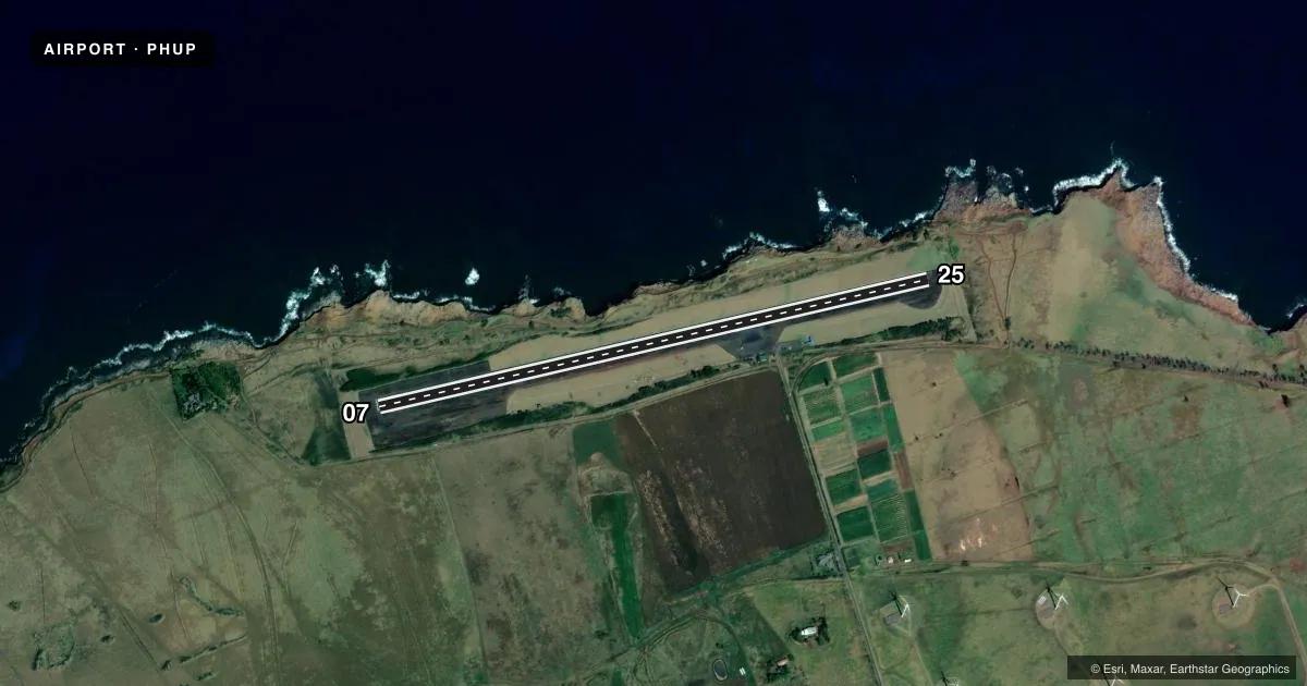
Runways & pattern
Full pagePattern entry · RWY 07
LEFT TRAFFICRunway end performance
| End | TORA | TODA | ASDA | LDA | VGSI | Approach lights | Obstruction |
|---|---|---|---|---|---|---|---|
| 25 | — | — | — | — | — | — | 25', hill, 500' from thr, 120' R of cntrln, slope 12 |
Declared distances in feet. TORA = takeoff run available, TODA = takeoff distance, ASDA = accelerate-stop, LDA = landing distance.
Airport sketch
Runways drawn to scale from FAA survey coordinates, rendered over satellite imagery. Not for navigation.
Approaches & charts
Services on the field
Fuel grades, oxygen, maintenance, ramp storage and lighting — as declared to the FAA by the airport operator.
Fuel & services
- Fuel
- Not available
- Oxygen (bottled)
- Not available
- Oxygen (bulk)
- Not available
- Airframe repair
- Not available
- Power plant repair
- Not available
- Other services
- PAJA
Ramp & ground
- Transient storage
- Tie-down
- Landing fee
- No fee published
- Customs
- Not available
- Lighting schedule
- SEE RMK
- Beacon schedule
- SS-SR
- Beacon
- White / Green (civil land)(WG)
- Wind indicator
- Lighted
- Segmented circle
- Yes
Fuel & FBOs
Cheapest 100LL and Jet A on the field and nearby. Always confirm with the FBO before taxi.
Airport notes
Surface conditions, obstructions, local procedures, lighting outages and other notes published with each FAA cycle.
General notes
- <TPA SMALL ACFT 800' MSL. LARGE ACFT 1500' MSL.
- PPR FOR TRANSIENT PARKING.
- PPR FM ARPT MGR PHONE (808)327-9520 FOR TRANSPORTATION OF DIVISION 1.1,1.2,1.3 EXPLOSIVES IN OR OUT OF AIRPORT.
- ALL HELICOPTERS CONFINE OPNS TO PAVED AREAS ONLY.
- OCCASIONAL FLOCKS OF BIRDS ON AND INVOF ARPT.
- SKYDIVING ACT ON AND IN VCNTY OF ARPT.
- FOR CD CTC HONOLULU CONTROL FACILITY AT 808-840-6262.
Lighting notes
- ACTVT MIRL RWY 07/25 - CTAF.
Other notes
- MANAGERERNEST ALFONSO MAINT PHONE WAIMEA-KOHALA 808-887-8126.
VFR map & nearby airports
VFR sectional. Tap any ICAO chip to open that airport.
Key facts · PHUP
Answer card- ICAO
- PHUP
- Name
- UPOLU
- Location
- HAWI, HAWAII
- Elevation
- 96 ft MSL
- Traffic pattern altitude
- 1,096 ft MSL (1,000 AGL)
- Control tower
- Non-towered (use CTAF)
- Total runways
- 1
- Longest runway
- 07/25 · 3,800 ft
- Published ILS approaches
- 0
- Published frequencies
- 1
- Magnetic variation
- 11°
- Current flight rules
- VFR
- Current wind
- 070° at 6 kt
- Favored runway now
- RWY 07
Upolu is in Hawi on the island of Hawaii. Field elevation is 96 ft MSL. The airport has one runway, 07/25, at 3,800 ft. There is no control tower. CTAF is 122.9. No ILS approaches are published here.
For pattern work, the published traffic pattern altitude is 800 ft MSL for small aircraft. Large aircraft use 1,500 ft MSL. That matters here because the field is low, near the coast. The published pattern is not the standard 1,000 ft AGL assumption. The runway lighting on 07/25 is medium intensity. It is activated by CTAF. Occasional bird activity is reported on and near the airport. Skydiving activity is also present in the area.
There are no on-field FBOs listed. Prior permission is required for transient parking. For clearance delivery, contact Honolulu Control Facility at 808-840-6262. Helicopters must stay on paved areas only. If you are planning a stop here, check current airport status with the airport operator or the FBO directly by phone before arrival.