METAR & TAF PHOG
Current METAR
Observed 21:54Z
PHOG 092154Z 04017G27KT 10SM FEW020 SCT055 29/22 A3008
- Wind
- 040° @ 17G27 kt
- Visibility
- 10 SM
- Temp / Dew
- 29°C / 22°C
- Altimeter
- 30.08 inHg
- Clouds
- SCT
- Density alt
- 1,550 ft
- Ceiling
- Unlimited
- Rules
- VFR
Airport info & contacts
Manager on record, flight service, ARTCC, attendance schedule and pattern altitude — published by the FAA and refreshed every 28 days.
Location
- From city
- 3 NM E
- VFR sectional
- HAWAIIAN ISLANDS
- ARTCC
- ZHN · HONOLULU CONTROL FACILITY
- NOTAM facility
- OGG (NOTAM-D)
Airport manager
- Name
- MARVIN MONIZ
- Phone
- 808-872-3808
- Address
- 1 KAHULUI AIRPORT ROAD, UNIT 5, KAHULUI HI 96732
Flight service · Hours
- FSS HNL
- HONOLULU1-800-WX-BRIEF
- Attendance
- ALL
Frequencies
Tap any row to copy the frequency to your clipboard.
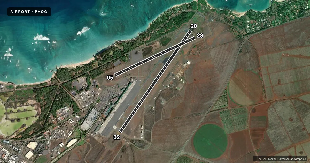
Runways & pattern
Full pagePattern entry · RWY 02
RIGHT TRAFFIC| Runway | Heading (°M) | Length | Surface | Traffic |
|---|---|---|---|---|
| 02/20Favored | 24° / 204° | 6,998 ft | ASPH | 02 R |
| 05/23 | 54° / 234° | 4,980 ft | ASPH | 23 R |
Runway end performance
| End | TORA | TODA | ASDA | LDA | VGSI | Approach lights | Obstruction |
|---|---|---|---|---|---|---|---|
| 02 | 6,995' | 6,995' | 6,995' | 6,995' | PAPI 4-box right(3°) | MALSR | 198', stack, 9704' from thr, 500' R of cntrln, slope 48 |
| 20 | 6,995' | 6,995' | 6,995' | 6,995' | PAPI 4-box left(3°) | — | 5', bldg, 300' from thr, 250' R of cntrln, slope 20 |
| 05 | — | — | — | — | PAPI 4-box left(3°) | — | 31', trees, 1200' from thr, slope 28 |
| 23 | — | — | — | — | — | — | 35', pole, 1500' from thr, slope 37 |
Declared distances in feet. TORA = takeoff run available, TODA = takeoff distance, ASDA = accelerate-stop, LDA = landing distance.
Airport sketch
Runways drawn to scale from FAA survey coordinates, rendered over satellite imagery. Not for navigation.
Approaches & charts
ILS · 1
Services on the field
Fuel grades, oxygen, maintenance, ramp storage and lighting — as declared to the FAA by the airport operator.
Fuel & services
- Fuel
- 100A
- Oxygen (bottled)
- Not available
- Oxygen (bulk)
- Not available
- Airframe repair
- Minor
- Power plant repair
- Minor
- Other services
- AFRT,AGRI,CARGO,INSTR,RNTL
Ramp & ground
- Transient storage
- Tie-down
- Landing fee
- No fee published
- Customs
- Not available
- Lighting schedule
- SEE RMK
- Beacon schedule
- SS-SR
- Beacon
- White / Green (civil land)(WG)
- Wind indicator
- Yes
- Segmented circle
- Yes
Fuel & FBOs
Cheapest 100LL and Jet A on the field and nearby. Always confirm with the FBO before taxi.
Airport notes
Surface conditions, obstructions, local procedures, lighting outages and other notes published with each FAA cycle.
General notes
- 570' LGTD TWR APRX 3 MI. W.
- 24 HRS PPR FOR DIVISION 1.1,1.2,1.3 EXPLOSIVES AND 4 HRS PPR FOR OTHER HAZARDOUS CARGO IN/OUT OF ARPT; CTC (808) 872-3830 0745-1630 OTHER TIMES (808) 872-3888.
- RAMP AREA E SIDE RY 02 UNDER STATE AUTHORITY. FAA NOT RESPONSIBLE FOR DIRECTION & CTL GND TFC IN AREA.
- MIGRATORY BIRD ACTIVITY BLO 1500 FT WI 5 NM RADIUS OF ARPT DURG AUG-MAY.
- MIL HEL OPS WITH PPR RSTRD TO THE SW CORNER OF HOT CARGO APRON (HAZMAT) N OF RWY 05/23.
- COMMUTER TERMINAL RAMP RESTRICTED TO ACFT 140000 LBS OR LESS.
- AREA E OF APCH END RY 02 DESIGNATED AS HELICOPTER OPER AREA. NO FIXED WING ACFT MAY OPER ON HELIPAD DURG OPNL HRS SR-SS.
- PPR FOR FIXED WING ACFT OPNS ON HELIPAD DURG NON-OPERATIONAL HRS CALL (808) 872-3880 5:15A-10:00P.
- ACCESS TO HELIPAD FM TWY C ONLY.
- DUE TO NONVISIBILITY ATCT UNABLE TO DETERMINE IF FLWG AREA IS CLEAR OF OBSTNS AND/OR TFC: PORTION OF TWY F BTN THE COMMUTER AIR TERMINAL & APCH END RY 05.
- DUE TO NONVISIBILITY ATCT UNABLE TO PROVIDE ATC SVC BTN ACFT & GROUND VEHICLES ON THE COMMUTER AIR TERMINAL S OF TWY F AND THE HELICOPTER AIR TERMINAL E OF APCH END RY 02.
- TSNT PARKING LCTD ON NE SECTION OF E RAMP.
- RY 02/20 SINGLE-BELLY TWIN TANDEM (SBTT) GWT 460,000 LBS.
- ACFT OVR 30,000 LB LDG ON RY 02/20 UNA TO TURN OFF ONTO RY 05/23 DUE TO PAVEMENT COND.
- COMMUTER AIR TRML RSTRD TO PART 121 AND PART 135 OPRS ONLY. ACFT AT THE TRML SHALL CALL THE TWR ON 121.9 PRIOR TO PUSHBACK.
- FOR CD WHEN ATCT IS CLSD CTC HONOLULU CONTROL FACILITY AT 808-840-6262.
Lighting notes
- WHEN ATCT CLSD ACTVT MALSR RWY 02; PAPI RWY 20; PAPI RWY 05; HIRL RWY 02/20; MIRL RWY 05/23 - CTAF.
Fuel notes
- 100JET A FUEL AVBL 0700-1800, OTHER TIMES BY PRIOR ARRANGEMENT WITH FBO 24 HRS, (808) 871-5572, OR (808) 873-6060. 100 OCTANE FUEL AVBL 24 HOURS SELF-SERVICE.
Runway surface & condition
- 02/20PCR VALUE: 480/F/D/X/T
- 05/23PCR VALUE: 670/F/A/X/T
Approach & departure obstructions
- 05+6 FT EXTNDD GND 200 FT FM THLD & 220 FT EACH SIDE CNTRLN; +32 FT LGTD WINDSOCK 0 FT FM THLD & 230 FT SE OF CNTRLN.
- 20HIGH TREES 600 FT NW CNTRLN EXTDD RY 20.
- 05PAPI UNUSBL BYD 4 NM FM THR DUE TO RAPIDLY RISING TERRAIN.
Other notes
- INDEX D ARPT; HWVR, CAN ACCOMMODATE INDEX E AS RQRD. CALL AMGR PRIOR TO ARR.
- MANAGERMARVIN.A.MONIZ@HAWAII.GOV
VFR map & nearby airports
VFR sectional. Tap any ICAO chip to open that airport.
Key facts · PHOG
Answer card- ICAO
- PHOG
- Name
- KAHULUI
- Location
- KAHULUI, HAWAII
- Elevation
- 55.4 ft MSL
- Traffic pattern altitude
- 1,055.4 ft MSL (1,000 AGL)
- Control tower
- Towered · 0600-2300 (MAR-NOV) 0600-2400 (NOV-MAR)
- Total runways
- 2
- Longest runway
- 02/20 · 6,998 ft
- Published ILS approaches
- 1
- Published frequencies
- 19
- Magnetic variation
- 11°
- Current flight rules
- VFR
- Current wind
- 040° at 17 kt
- Favored runway now
- RWY 02
Kahului Airport sits in Kahului, Hawaii on Maui. Field elevation is 55.4 ft MSL. The airport has two asphalt runways. The longest is runway 02/20 at 6,998 ft. Runway 05/23 is 4,980 ft. The tower is open 0600-2300 MAR-NOV. It runs 0600-2400 NOV-MAR. One ILS approach is published for runway 02.
Pattern altitude is not published. Use 1,000 ft AGL for light piston traffic unless the current Chart Supplement says otherwise. Published remarks matter here. Runway 05 has a lighted windsock close to the threshold. Runway 20 has high trees northwest of the extended centerline. Aircraft over 30,000 lb landing on 02/20 cannot turn off onto 05/23 because of pavement condition.
Atlantic Aviation is on the field. It carries 100LL and Jet A. Signature Aviation is also on the field. It carries Jet A and Jet A Prist. Jet A is available from 0700 to 1800. Outside those hours, fuel is available by prior arrangement with the FBO. 100 octane fuel is available 24 hours self-service. Kahului is in Class C airspace. Expect busy traffic and stay sharp on taxi instructions, especially on the east side of runway 02 where the ramp is under state authority.