METAR & TAF PHLU
PHLU does not publish a METAR.
Showing the nearest reporting station: PHMK (MOLOKAI) · 7.7 NM away. Conditions at PHLU may differ.
METAR · PHMK
Observed 22:54Z
PHMK 092254Z 05008G22KT 040V100 10SM FEW040 29/20 A3006 RMK AO2 PK WND 07026/2229 SLP181 T02890200 $
- Wind
- 050° @ 8G22 kt
- Visibility
- 10 SM
- Temp / Dew
- 29°C / 20°C
- Altimeter
- 30.06 inHg
- Clouds
- FEW
- Density alt
- 1,536 ft
- Ceiling
- Unlimited
- Rules
- VFR
Airport info & contacts
Manager on record, flight service, ARTCC, attendance schedule and pattern altitude — published by the FAA and refreshed every 28 days.
Location
- From city
- 2 NM N
- VFR sectional
- HAWAIIAN ISLANDS
- Pattern altitude
- 776 ft AGL · 800 ft MSL
- ARTCC
- ZHN · HONOLULU CONTROL FACILITY
- NOTAM facility
- MKK (NOTAM-D)
Airport manager
- Name
- MARVIN MONIZ
- Phone
- 808-872-3830
- Address
- KAHULUI AIRPORT, KAHULUI HI 96732
Flight service · Hours
- FSS HNL
- HONOLULU1-800-WX-BRIEF
- Attendance
- MON-FRI · 0700-1530
Frequencies
Tap any row to copy the frequency to your clipboard.
Runways & pattern
Full pagePattern entry · RWY 05
LEFT TRAFFICRunway end performance
| End | TORA | TODA | ASDA | LDA | VGSI | Approach lights | Obstruction |
|---|---|---|---|---|---|---|---|
| 05 | — | — | — | — | PAPI 2-box left(3°) | — | — |
Declared distances in feet. TORA = takeoff run available, TODA = takeoff distance, ASDA = accelerate-stop, LDA = landing distance.
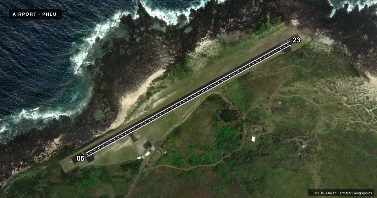
Airport sketch
Runways drawn to scale from FAA survey coordinates, rendered over satellite imagery. Not for navigation.
Approaches & charts
Services on the field
Fuel grades, oxygen, maintenance, ramp storage and lighting — as declared to the FAA by the airport operator.
Fuel & services
- Fuel
- Not available
- Oxygen (bottled)
- Not available
- Oxygen (bulk)
- Not available
- Airframe repair
- Not available
- Power plant repair
- Not available
Ramp & ground
- Transient storage
- Not published
- Landing fee
- No fee published
- Customs
- Not available
- Lighting schedule
- SEE RMK
- Beacon schedule
- SS-SR
- Beacon
- White / Green (civil land)(WG)
- Wind indicator
- Lighted
- Segmented circle
- Yes
Fuel & FBOs
Cheapest 100LL and Jet A on the field and nearby. Always confirm with the FBO before taxi.
Airport notes
Surface conditions, obstructions, local procedures, lighting outages and other notes published with each FAA cycle.
General notes
- SEE AREA NOTICES - TRAFFIC ADVISORIES AT NON-TOWER ARPTS.
- 24 HRS PPR FOR DIVISION 1.1,1.2,1.3 EXPLOSIVES AND 4 HRS PPR FOR OTHER HAZARDOUS MATERIAL IN/OUT OF ARPT CTC 808-567-9660/9663.
- PPR FM ST DEPT OF HEALTH COMMUNICABLE DISEASE DIV TO ENTER SETTLEMENT AREA PHONE HONOLULU 808-586-4580.
- DEER & WILD ANIMALS ON & INVOF ARPT AT NIGHT.
- OCT-MAY LARGE WAVES IMPACTING SHORELINE RESULTING IN SALT WATER SPRAYS 40 FT HIGH.
- FOR CD CTC HONOLULU CONTROL FACILITY AT 808-840-6262.
Lighting notes
- ACTVT MIRL RWY 05/23 MED INTST ONLY - CTAF. PAPI RWY 05 DAYTIME VFR USE ONLY.
Approach & departure obstructions
- 05PAPI UNUSBL BYD 2.2 NM. TERRAIN PENETRATES PAPI SAFETY SLOPE AT 2.7 NM. PAPI OTS INDEFLY.
Other notes
- MANAGERARPT OPNS/MAINT/ MAN/ADM/-MR. ANTONE KALILIKANE MOLOKAI (808) 567-9660.
VFR map & nearby airports
VFR sectional. Tap any ICAO chip to open that airport.
Key facts · PHLU
Answer card- ICAO
- PHLU
- Name
- KALAUPAPA
- Location
- KALAUPAPA, HAWAII
- Elevation
- 23.9 ft MSL
- Traffic pattern altitude
- 799.9 ft MSL (776 AGL)
- Control tower
- Non-towered (use CTAF)
- Total runways
- 1
- Longest runway
- 05/23 · 2,700 ft
- Published ILS approaches
- 0
- Published frequencies
- 1
- Magnetic variation
- 11°
- Current flight rules
- VFR
- Current wind
- 050° at 8 kt
- Favored runway now
- RWY 05
Kalaupapa Airport sits in Kalaupapa, Hawaii on the north shore of Molokai. Field elevation is 23.9 ft MSL. The airport has one runway. Runway 05/23 is 2,700 ft asphalt, with magnetic headings 61° and 241°. There is no control tower. CTAF is 122.9. Pattern altitude is 776 ft AGL, or 799.9 ft MSL.
No ILS approaches are published here. That makes current weather, local terrain and visual cues more important than usual. The published remarks also matter. Medium intensity runway lights on 05/23 are activated by CTAF only. The PAPI on runway 05 is for daytime VFR use only. It is out of service indefinitely. Terrain also penetrates the PAPI safety slope beyond 2.7 NM. Deer and other wild animals are reported on and near the airport at night. From October to May, large waves can throw salt spray up to 40 feet high along the shoreline.
There are no on-field FBOs listed in the facts. Contact the airport operator directly before arrival if you need local support. Airport operations, maintenance, management and administration are handled by Mr. Antone Kalilikane Molokai at 808-567-9660. For clearance delivery, contact Honolulu Control Facility at 808-840-6262. Check the current FAA Chart Supplement for any current traffic advisories, settlement access limits, or other local restrictions before you go.